- Caesarea
-
For other uses, see Caesarea (disambiguation).
Caesarea 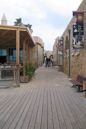
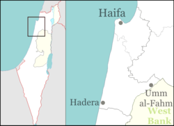
Caesarea MaritimaHebrew קֵיסָרְיָה (Translit.) Keisarya Also spelled Qesarya (officially) District Haifa Coordinates 32°30′N 34°54′E / 32.5°N 34.9°ECoordinates: 32°30′N 34°54′E / 32.5°N 34.9°E Population 4,400 (2006) Jurisdiction 35,000 dunams (35 km2; 14 sq mi) Caesarea (Hebrew: קֵיסָרְיָה; Arabic: قيسارية, Kaysaria; Greek: Καισάρεια) is a town in Israel located mid-way between Tel Aviv and Haifa (45 km), on the Israeli Mediterranean coast near the city of Hadera. The town was built by Herod the Great about 25-13 BCE as the port city of Caesarea Maritima. Modern Caesarea as of December 2007 has a population of 4,500 people.[1] It is the only Israeli locality managed by a private organization, the Caesarea Development Corporation,[2] and also one of the most populous localities not recognized as a local council. It lies under the jurisdiction of the Hof HaCarmel Regional Council.
Contents
History
Early history
Main article: Caesarea MaritimaCaesarea is believed to have been built on the ruins of Stratonospyrgos (Straton's Tower), founded by Straton I of Sidon, and was likely an agricultural storehouse in its earliest configuration.[3] In 90 BCE, Alexander Jannaeus captured Straton's Tower as part of his policy of developing the shipbuilding industry and enlarging the Hasmonean kingdom. Straton's Tower remained a Jewish city for two generations, until the Roman conquest of 63 BCE when the Romans declared it an autonomous city. The pagan city underwent vast changes under Herod the Great, who renamed it Caesarea in honor of the Roman emperor, Caesar Augustus.
In 22 BCE, Herod began construction of a deep sea harbor and built storerooms, markets, wide roads, baths, temples to Rome and Augustus, and imposing public buildings.[4] Every five years the city hosted major sports competitions, gladiator games, and theatrical productions in its theatre overlooking the Mediterranean Sea.
Caesarea also flourished during the Byzantine period. In the 3rd century, Jewish sages exempted the city from Jewish law, or Halakha, as by this time the majority of the inhabitants were non-Jewish.[5] The city was chiefly a commercial centre relying on trade. The area was only seriously farmed during the Rashidun Caliphate period, apparently until the Crusader conquest in the eleventh century.[5] Over time, the farms were buried under the sands shifting along the shores of the Mediterranean.
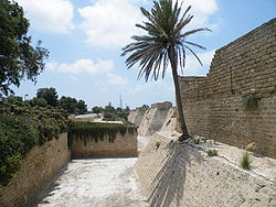
In 1251, Louis IX fortified the city. The French king ordered the construction of high walls (parts of which are still standing) and a deep moat. However, strong walls could not keep out the sultan Baybars, who ordered his troops to scale the walls in several places simultaneously, enabling them to penetrate the city.
Caesarea lay in ruins until the nineteenth century when the village of Qisarya (Arabic: قيسارية, the Arabic name for Caesarea) was established in 1884 by Muslim immigrants from Bosnia, who built a small fishing village on the ruins of the Crusader fortress on the coast.[6][7] The kibbutz of Sdot Yam was established 1 km south in 1940. Many of Qisarya's inhabitants left before 1948, when a railway was built bypassing the port, ruining their livelihood. Qisarya had a population of 960 in 1945.[8] During the 1948 Arab-Israeli War part of the population fled for fear of attacks, before it was conquered by Jewish forces in February, after which the remaining inhabitants were expelled and the village houses were demolished.[9] During the conquest of Qisarya a number of the Arab inhabitants were killed. According to a testimony collected from Battalion members obtained by Israeli historian Uri Milstein: "In February 1948, the 4th Battalion of Palmach, under the command of Josef Tabenkin, conquered Caesaria."[10]
Modern town
With the establishment of Israel, the Rothschild family made an agreement to transfer most of their vast land holdings to the new state. A different arrangement was reached, however, for the 35,000 dunams of land the family owned in and around modern Caesarea: after turning over the land to the state, it was leased back (for a period of 200 years) to a new charitable foundation. In his will, Edmond James de Rothschild stipulated that this foundation would further education, arts and culture, and welfare in Israel. The Caesarea Edmond Benjamin de Rothschild Foundation was formed and run based on the funds generated by the sale of Caesarea land which the Foundation is responsible for maintaining. The Foundation is owned half by the Rothschild Family, and half by the State of Israel.
The Foundation established the Caesarea Edmond Benjamin de Rothschild Development Corporation Ltd. (CDC) in 1952 to act as its operations arm. The company transfers all profits from the development of Caesarea to the Foundation, which in turns contributes to organizations that advance higher education and culture across Israel.
Geography
Caesarea is located on the Israeli Mediterranean coastal plain, the historic land bridge between Europe, Asia and Africa approximately halfway between the major cities of Tel Aviv 45 kilometers (28 mi) and Haifa 45 kilometers (28 mi). Caesarea is situated approximately 5 kilometers (3 mi) northwest of the city of Hadera, and is bordered to the east by the Caesarea Industrial Zone and the city of Or Akiva. Directly to the north of Caesarea is the town of Jisr az-Zarqa.
Caesarea is divided into a number of residential zones, known as clusters. The most recent of these to be constructed is Cluster 13, which, like all the clusters, is given a name: in this case, "The Golf Cluster", due to its close proximity to the Caesarea Golf Course. These neighborhoods are universally affluent, although they vary significantly in terms of average plot size.
Beyond the eastern boundary of the residential area of Caesarea is Highway 2, Israel's main highway linking Tel Aviv to Haifa. Caesarea is linked to the road by the Caesarea Interchange in the south, and Or Akiva Interchange in the center. Slightly further to the east lies Highway 4, providing more local links to Hadera, Binyamina, Zichron Yaakov, and the moshavim and kibbutzim of Emek Hefer. Highway 65 starts at the Caesarea Interchange and runs westwards into the Galilee and the cities of Pardes Hanna-Karkur, Umm al-Fahm, and Afula.
Caesarea shares a railway station with nearby Pardes Hanna-Karkur which is situated in the Caesarea Industrial Zone and is served by the suburban line between Binyamina and Tel Aviv with two trains per hour. The Binyamina Railway Station, a major regional transfer station, is also located nearby.
Town planning
The modern town of Caesarea follows design leads from the garden suburb movement and is set out as a number of residential clusters established sequentially as the town has developed.[citation needed]
Demographics
As of December 2007, Caesarea had a population of approximately 4,500.[1] This represented a 2.5% growth rate over the past year, in part due to the development of new homes in the new Cluster 13. Estimations show that as of mid-2008, the population had risen by about 100 to 4,600.[1]
Caesarea Foundation
The Caesarea Edmond Benjamin de Rothschild Development Corporation (Hebrew: החברה לפיתוח קיסריה אדמונד בנימין דה רוטשילד) is the operational arm of the Caesarea Edmond Benjamin de Rothschild Foundation, whose goal is to establish a unique community that combines quality of life and safeguarding the environment with advanced industry and tourism.
Today, the Chairman of the Caesarea Foundation and the CDC is Baron Benjamin de Rothschild, the great grandson of the Baron Edmond de Rothschild. The deputy chairman is Avraham Biger. In recent years, the Foundation has donated over 100 million shekels to organizations such as the Interdisciplinary Center in Herzliya, the Bezalel Academy, Yad Vashem, the Open University of Israel, as well as to theaters, museums, and musical projects across the country. Sizeable grants have also been made to the neighboring towns of Or Akiva and Jisr az-Zarqa.
Caesarea remains today the only locality in Israel managed by a private organization rather than a municipal government. As well as carrying out municipal services, the Caesarea Development Corporation markets plots for real-estate development, manages the nearby industrial park, and runs the Caesarea's golf course and country club, Israel's only 18-hole golf course.
Modern Caesarea is one of Israel's most upscale residential communities. The Baron de Rothschild still maintains a home in Caesarea, as do many business tycoons from Israel and abroad.
Economy
Caesarea is very much a dormitory settlement with many of its residents commuting to Tel Aviv and Haifa. On the outskirts of Caesarea, however, lies the Caesarea Business Park, a 3500 dunam business park. The park houses approximately 170 companies and employs about 5,500 people. Industry in the park varies from distribution to hi-tech sectors. The residential neighborhoods have a small shopping concourse with a newsagent, supermarket, optician, and bank. There are a number of restaurants and cafes scattered across the town, with a number within the ancient port.
Culture
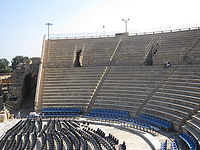
The Roman theatre
The Roman theatre, located at the site, often hosts concerts by major Israeli and international artists, such as Shlomo Artzi, Yehudit Ravitz, Mashina, Deep Purple, Bjork and others. Furthermore, the port has in recent years become home to the annual Caesarea Jazz Festival which offers three evenings of top-class jazz performances by leading international artists. Furthermore, the Ralli Museum in Caesarea houses a large collection of South American art and several Salvador Dalí originals.[11]
Sport
Further information: Caesarea Golf & Country ClubWithin Israel, Caesarea is noted for being the location of the country's only full-size golf course.[12] The idea for the Caesarea Golf and Country Club was originated after James de Rothschild was reminded by the dunes surrounding Caesarea of Scotland's sandy links golf courses. Upon his death, the James de Rothschild Foundation established the course. In 1958 a Golf Club Committee was established, and a course was built. American professional golfer Herman Barron, the first Jewish golfer to win a PGA Tour event, helped develop the course.[13] It was officially opened in 1961 by Abba Eban. The Caesarea Golf Club has hosted international golf competitions every four years in the Maccabiah Games. The course was redesigned and rebuilt by world-famous golf course designer Pete Dye, starting August 2007 and finishing May 2009.
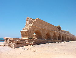
Caesarea has a country club, effectively a health complex housing a semi-Olympic-sized swimming pool, gym, tennis club, and martial arts studios.[14] Swimmers use the Acquaduct Beach.[citation needed]
Notable residents
- Procopius Byzantine-era historian and scholar
- Ezer Weizman, seventh President of Israel
- Keren Ann, pop singer
- Arcadi Gaydamak, Russian-Israeli businessman
- Eitan Wertheimer, industrialist
- Benjamin Netanyahu, politician and the current Prime Minister of Israel
- Avraham Yosef Schapira, politician and a businessman
See also
References
Bibliography
- Levine, Lee I (1975). Caesarea under Roman rule. Brill Archive. ISBN 9789004040137. http://books.google.com/books?id=pscUAAAAIAAJ. Retrieved 10 March 2010.
Notes
- ^ a b c "Table 3 - Population of Localities Numbering Above 1,000 Residents and Other Rural Population". Israel Central Bureau of Statistics. 2008-06-30. http://www.cbs.gov.il/population/new_2009/table3.pdf. Retrieved 2008-11-22.
- ^ About the CDC
- ^ . JSTOR 1356838.
- ^ Crossan, John Dominic (1999) Birth of Christianity: Discovering What Happened in the Years Immediately After the Execution of Christ Continuum International Publishing Group, ISBN 0567086682 p 232
- ^ a b Safrai, Zeev (1994) The Economy of Roman Palestine Routledge, ISBN 041510243X p 374
- ^ Laurence Oliphant, Haifa; or, Life in Palestine (Edinburgh, Blackwood, 1887), p182.[1]
- ^ "Caesarea". Jewish Virtual Library. http://www.jewishvirtuallibrary.org/jsource/vie/Caesarea.html. Retrieved 2007-10-22.
- ^ Government of Palestine, Village Statistics, 1945.
- ^ Benny Morris, The Birth of the Palestinian Refugee Problem, 1947-1949, Cambridge University Press, 1989.
- ^ The Palestinian Nakba: The Register of Depopulated Localities in Palestine by THe Palestinian Return Centre, Sept 2000, p. 18
- ^ "Caesarea". Weizmann Institute. Archived from the original on 2008-01-19. http://web.archive.org/web/20080119145143/http://www.wisdom.weizmann.ac.il/~bazlov/israel/area_centre.html. Retrieved 2008-01-26.
- ^ Golf Digest magazine, May 2010
- ^ Herman Barron bio page on International Jewish Sports Hall of Fame website
- ^ http://www.caesarea.com/pages_e/640.aspx Country Club - About
External links
- Places To Visit in Caesarea (English)
- Caesarea Development Corporation
- Pete Dye Golf Project Caesarea
- Caesarea, photo
- Caesarea, Power Station, photo
Kibbutzim Beit Oren · Ein Carmel · HaHotrim · Ma'agan Michael · Ma'ayan Tzvi · Nahsholim · Neve Yam · Sdot YamMoshavim Bat Shlomo · Beit Hanania · Dor · Ein Ayala · Geva Carmel · HaBonim · Kerem Maharal · Megadim · Nir Etzion · Ofer · TzrufaCommunal settlements Other villages Categories:- Hof HaCarmel Regional Council
- Caesarea (Israel)
- Planned communities
Wikimedia Foundation. 2010.

