- Dor (moshav)
-
Dor 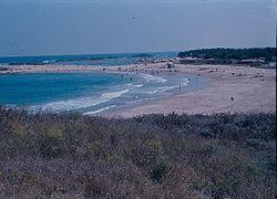
Dor beachFounded 1949 Founded by Greek immigrants Council Hof HaCarmel Region Carmel Affiliation Moshavim Movement Coordinates 32°36′26.63″N 34°55′19.19″E / 32.6073972°N 34.9219972°ECoordinates: 32°36′26.63″N 34°55′19.19″E / 32.6073972°N 34.9219972°E 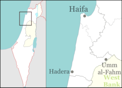
 Dor
DorDor (Hebrew: דּוֹר) is a moshav in northern Israel. Located near Zikhron Ya'akov, it falls under the jurisdiction of Hof HaCarmel Regional Council. In 2006 it had a population of 343. The moshav was established on the land of the depopulated Palestinian village named Tantura, east of the old village site, in 1949.[1][2]
The moshav was established by immigrants from Greece, who were later joined by immigrants from Iraq. It was named after the ancient Phoenician city of Dor, which inhabited by the tribe of Manasseh in the Israelite period. The city is mentioned in the Bible, in the Book of Joshua 17:11 and 1 Chronicles 7:29). It was renamed Tantura after the Arab conquest.[3] The ancient city of Dor was situated on the excavated tell north of today's moshav, overlooking Kibbutz Nahsholim.
References
- ^ Morris, 2004, p. xxii, settlement #186.
- ^ Khalidi, 1992, p.195
- ^ Life with Neanderthal Man and Napoleon too at the Mt. Carmel caves and the beach at Tel Dor
Bibliography
- Khalidi, Walid (1992), All That Remains: The Palestinian Villages Occupied and Depopulated by Israel in 1948, Washington D.C.: Institute for Palestine Studies, ISBN 0-88728-224-5
- Morris, Benny (2004). The Birth of the Palestinian Refugee Problem Revisited. Cambridge University Press. ISBN 9780521009676. http://books.google.com/?id=uM_kFX6edX8C&printsec=frontcover&dq=benny+morris&q.
Kibbutzim Beit Oren · Ein Carmel · HaHotrim · Ma'agan Michael · Ma'ayan Tzvi · Nahsholim · Neve Yam · Sdot YamMoshavim Bat Shlomo · Beit Hanania · Dor · Ein Ayala · Geva Carmel · HaBonim · Kerem Maharal · Megadim · Nir Etzion · Ofer · TzrufaCommunal settlements Other villages Categories:- Hof HaCarmel Regional Council
- Moshavim
- Populated places established in 1949


Wikimedia Foundation. 2010.