- Israeli coastal plain
-
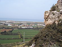
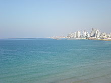
The Israeli coastal plain (Hebrew: מישור החוף, Mishor HaḤof) is the narrow coastal plain along Israel's Mediterranean Sea coast which houses 70% of the country's population. The plain extends 187 kilometres (116 mi) north to south and is divided into a number of areas; the Plain of Zebulun (north of Haifa), Hof HaCarmel (from Haifa to Mount Carmel), the Sharon plain (from Mount Carmel to Tel Aviv), and the Plain of Judea (from Tel Aviv to Zikim).[1] For its duration, the plain has sandy beaches and a Mediterranean climate.
Contents
Physical geography
The area was historically fertile in Biblical times, some of it being continually farmed ever since, although much turned over time into swampland, having to be converted back by Zionist pioneers.[1] Today, the area is the center of the country's citrus farms, and contains some of the country's most successful agricultural settlements. The plain has soils made of two sorts of thick river deposits; one dark and heavy - ideal for growing field crops, and the other thin and sandy - ideal for growing citrus fruits.[1]
Despite its length, the plain is only crossed by two significant rivers; the Yarkon, which is 27 kilometres (17 mi) long flowing from the Petah Tikva area into the Mediterranean, and the Kishon which is 43 kilometres (27 mi) long, flowing into the Gulf of Acre north of Haifa.[1]
Human geography
About 57% of Israel's population lives in the coastal plain, much of them in the Tel Aviv metropolitan area (Gush Dan) and Haifa metropolitan area.[1] It is the most predominantly Jewish geographical region of Israel and conversely the most predominantly Jewish region in the world, as Jews make up over 96% of the population in this region compared to 75% in the Negev, 70% in the Israeli portion of the Judean Mountains, and only 50% in the Galilee, and the Golan Heights.
About 4,320,000 people live on the Israeli Coastal Plain (57% of the total Israeli population of 7,600,000, or 4,320,000 people). 4,200,000 million of them are Jews (97.2%), and 120,000 are Israeli Arabs. This accounts for approximately one-third of the world Jewish population, and almost three-quarters of Israeli Jews.
The Israeli Coastal Plain has been populated for thousands of years, with references to it in Biblical literature. Recent research however, has concluded that the Coastal Plain was inhabited 5,500 years ago during the Bronze Age. It is thought that at this time, shifting settlement patterns in the land were caused by climate change which led to flooding of the area which had been a populated commercial and settlement center, and the creation of many swamps.[2] Settlements are thought to have been spread across the plain, from Gaza up to the Galilee, with the land being an important trade route for the Egyptians.
Regions
The coastal plain includes the following geographical regions (from north to south):
Western Galilee
The Western Galilee (also known as North coast or Plain of Zebulun) region of the Coastal Plain stretches from Rosh HaNikra in the far North, down to Israel's third-largest city, Haifa. It is a fertile region containing the city of Nahariya and many moshavim and kibbutzim. The coast here has many small islands off of it.[3] Often regarded as a separate region is the Acre coastal plain, which is crowded with urban areas including Acre and the northern Krayot suburbs of Haifa as well as more agricultural areas.[3]
Hof HaCarmel
The Hof HaCarmel (Carmel) region covers the area from Haifa down to the town of Zikhron Ya'aqov, the coast nearby Mount Carmel. The soil of the Hof HaCarmel plain is rich and apart from the main city of Haifa in the north, most settlement here is made up of farming communities.[3]
Sharon Plain
The Sharon plain is the next stage down the Coastal Plain, running from Zikhron Ya'aqov to Tel Aviv's Yarkon River. This area is Israel's most densely populated, containing a number of large towns and cities including Netanya and Herzliya as well as smaller communities inland.[3]
Central Coastal Plain
Running from Northern Tel Aviv's Yarkon River to Nahal Shikma, the Central Coastal Plain contains cities such as Bat Yam and Rishon LeZion, and agricultural communities.[3]
Southern Coastal Plain
Also known as the Shephelah, Plain of Judea, and Western Negev, the Southern Coastal Plain extends south to the Gaza Strip and is divided into two:
- the Besor region, a savanna-type area with a relatively large number of communities, in the north
- the Agur-Halutsa region in the south which is very sparsely populated.[3]
References
- ^ a b c d e "Geographic Regions". http://library.thinkquest.org/26823/georegions.htm. Retrieved 2008-01-14.
- ^ "Researchers say communities abandoned the coastal plain in the Bronze Age due to climate change and flooding". Haaretz. 2007-08-23. http://www.haaretz.com/hasen/pages/ShArt.jhtml?itemNo=896578. Retrieved 2008-03-02.
- ^ a b c d e f "The coastal plain". http://www.goisrael.com/Tourism_Eng/Tourist+Information/Discover+Israel/Geographic+Regions/The+coastal+plain.htm. Retrieved 2008-01-26.
Categories:- Regions of Israel
- Landforms of Israel
- Plains of Israel
Wikimedia Foundation. 2010.


