Oakwood (Pittsburgh)

Oakwood (Pittsburgh)

Coordinates: 40°25′34″N 80°04′01″W / 40.426°N 80.067°W / 40.426; -80.067

Oakwood
Pgh locator oakwood.svg
Neighborhood in Pittsburgh, Pennsylvania
Coordinates: 40°25′34″N 80°04′01″W / 40.426°N 80.067°W / 40.426; -80.067
Population (1990): 1108[1]
Population (2000): 1028[1]
Area: 0.252 sq mi (0.65 km2)[1]

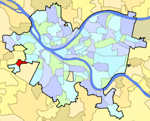
Oakwood is a neighborhood in Pittsburgh, Pennsylvania's southwest city area. It has a zip code of 15205, and has representation on Pittsburgh City Council by the council member for District 2 (West Neighborhoods).

Contents

Demographics

As of the census of 2000, there were 1,028 people, 523 households, and 251 families residing in Oakwood. Of the 1,028 people residing in Oakwood, 448 were male and 580 were female. 255 of the housing units were owner-occupied and 268 were renter-occupied. There were 102 households with persons age 18 and younger and 215 households with persons age 65 and older.

Surrounding communities

See also

References

  1. ^ a b c Census: Pittsburgh. Pittsburgh Department of City Planning. January 2006. http://www.city.pittsburgh.pa.us/cp/assets/census/2000_census_pgh_jan06.pdf. Retrieved 2007-07-19. 

External links


Wikimedia Foundation. 2010.

Игры ⚽ Нужна курсовая?

Look at other dictionaries:

  • List of Pittsburgh neighborhoods — This is a list of neighborhoods in the city of Pittsburgh, Pennsylvania. Historically, neighborhood development followed ward boundaries, but many neighborhoods have been re shaped by the City Planning Commission in the post industrial era.[1]… …   Wikipedia

  • East Carnegie (Pittsburgh) — Infobox Pittsburgh neighborhood name = East Carnegie caption = locator caption = locator population1990 = 605 population2000 = 485 latd = 40.420 longd = 80.071 area sqmi = 0.432East Carnegie is a neighborhood located southwest of downtown… …   Wikipedia

  • West End (Pittsburgh) — Infobox Pittsburgh neighborhood name = West End aka = West End Valley caption = locator caption = locator population1990 = 441 population2000 = 466 latd = 40.4355 longd = 80.0351 area sqmi = 0.2 zip = 15220West End (originally named… …   Wikipedia

  • Westwood (Pittsburgh) — Infobox Pittsburgh neighborhood name = Westwood caption = locator caption = locator population1990 = 3282 population2000 = 3093 latd = 40.434 longd = 80.049 area sqmi = 0.692Westwood is a neighborhood in Pittsburgh, Pennsylvania s West End Region …   Wikipedia

  • List of cemeteries — This list of cemeteries compiles notable cemeteries, mausoleums and other places people are buried, worldwide. Reasons for notability include their design, their history and their interments.Argentina*La Recoleta Cemetery, Buenos Aires burial… …   Wikipedia

  • List of Veterans Affairs medical facilities — See also: List of Veterans Affairs medical facilities by state Contents 1 VISNs 1 through 23 …   Wikipedia

  • List of shopping malls in the United States — This is a list of shopping malls in the United States of America. States Alabama * Bel Air Mall Mobile * Bridge Street Town Centre Huntsville * Colonial Brookwood Village Mountain Brook (Birmingham) * Madison Square Mall Huntsville * Parkway… …   Wikipedia

  • Eastern Michigan Eagles football — Current season …   Wikipedia

  • Lawrence County, Pennsylvania — Lawrence County Courthouse …   Wikipedia

  • John F. Street — John Street 97th Mayor of Philadelphia, Pennsylvania …   Wikipedia

Share the article and excerpts

Direct link
Do a right-click on the link above
and select “Copy Link”