- Oxley Creek
-
Oxley Creek 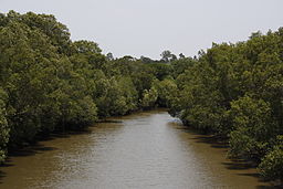 Oxley Creek seen from Sherwood Road
Country Australia State Queensland Region South East Queensland Part of Brisbane River Source Mount Perry Mouth confluence with the Brisbane River - location Tennyson Oxley Creek is situated in south east Queensland, Australia and is one of the major tributaries of the Brisbane River with an estimated 260 square kilometres in area. Water from the large catchment area flows into Oxley Creek as it flows through the low hills in Beaudesert Shire, and other local government areas of Logan City, Ipswich and into Brisbane.
Oxley Creek is crossed by the Ipswich Motorway and Logan Motorway. In the suburbs of Oxley, Corinda and Tennyson the lower reaches of the creek contain the Oxley Creek Canoe Trail and are bordered by houses, parks, a driving range and sports fields. In these areas it is heavily polluted. These winding areas for the creek's catchment are prone to flooding, especially if there is an overflow on the Rocklea flood plains from the tributary Stable Swamp Creek.
Contents
History
The creek was named after John Oxley who first surveyed it. Initially Oxley had called the creek the Canoe River. This was in recognition of the first Europeans to reach the creek, Thomas Pamphlett, John Finnegan, Richard Parsons who reached the area after being shipwrecked on Stradbroke Island. At Oxley Creek the three found two canoe, one of which was used to cross the river and travel downstream.[1]
As early as 1828, hoop pine was being felled near the mouth of Oxley Creek and in the area that is today known as Chelmer and Graceville.[1] In 1852 the first public bridge over the creek was built for the dray road that led to Ipswich.[1] By the 1860s timber cutters from Brisbane were entering the Oxley Creek flood plain.[1] The creek and tributaries were described as being surrounded by dense scrubland with patches of sub-tropical rainforest.
Tributaries
Tributaries of Oxley Creek include Crewes Creek, Blunder Creek, Sheep Station Gully, Stable Swamp Creek, Rocky Water Holes Creek, Little Doris Creek and Moolabin Creek.
The headwaters of Oxley Creek begin on the northern slopes of Mount Perry, south of Ipswich, in Beaudesert Shire. From here, the creek flows northwards about 70 kilometres, eventually discharging into the Brisbane River at Tennyson.
Oxley Creek's upper catchment is sparsely populated and largely natural, with forested hills and grazing land. However, in other parts of the catchment, urban development has had great impact. In the middle and lower catchment, Oxley Creek and its tributaries flow through 28 Brisbane suburbs including Algester, Corinda, Darra, Durack, Forest Lake, Moorooka, Salisbury, Sunnybank Hills, Graceville and Sherwood. Major industrial areas of Acacia Ridge, Coopers Plains and Rocklea are located in the catchment, as well as waste water treatment plants at Oxley and Inala, and the vicinity of Archerfield Airport.
Environmental concerns
Residential and industry development, sewage, sediment, land clearing and sand mining in the catchment have greatly affected the water quality of Oxley Creek, particularly in its lower reaches. Key environmental issues that face the catchment are:
- Rapid population increase and development;
- Altered flow patterns of the Creek causing active erosion;
- Deteriorating water quality;
- Increased noise and vehicle movements;
- Waste disposal;
- Invasion of bushland by exotic plants and animals;
- Management of the extractive industries; and
- Day-to-day behaviour of residents and workers of the catchment.
Local councils and bushcare groups have worked to reduce sediment entering the creek by planting vegetation. By 2008 improvements had resulted in water quality tests on the creek system's rating lifting from a F to a D.[2]
Effluent from the Oxley Waste Treatment Centre was released into Oxley Creek during the 2010–2011 Queensland floods. Levels of bacteria 250 times higher than normal were recorded in the waterway.[3] Due to safety concerns parts of Oxley Creek were not immediately cleared of debris. Brisbane's Recovery Task Group has identified Oxley Creek along with a number of other waterways that are to be targeted in the recovery process that make take a number of years to restore.[4]
See also
References
- ^ a b c d Fones, Ralph (2006). Oxley! A mind of its own:a history of a suburb with attitude. 1850 - 1950. Oxley-Chelmer History Group. pp. 4—10. ISBN 0975146629.
- ^ "Oxley creek bonus", South West News: 2, 28 October 2008
- ^ Jamie Walker (29 January 2011). "Health alert as sewage spill becomes next threat for riverside homes". The Australian (News Limited). http://www.theaustralian.com.au/in-depth/queensland-floods/health-alert-as-sewage-spill-becomes-next-threat-for-riverside-homes/story-fn7iwx3v-1225996399738. Retrieved 28 February 2011.
- ^ "Creek debris will be cleared soon". The Satelite (APN News & Media). 28 February 2011. http://www.thesatellite.com.au/story/2011/02/28/creek-debris-will-be-cleared-soon/. Retrieved 28 February 2011.
External links
Coordinates: 27°31′53.32″S 152°59′37.26″E / 27.5314778°S 152.9936833°E
Categories:- Logan City
- Rivers of Queensland
- Tributaries of the Brisbane River
Wikimedia Foundation. 2010.