- Archipelago of San Andrés, Providencia and Santa Catalina
-
Archipelago of San Andres
Providencia and Santa Catalina
Archipiélago de San Andrés
Providencia y Santa Catalina— Department — 
Flag
Coat of armsMotto: Paraíso Turístico
Tourist ParadiseAnthem: Himno de San Andrés y Providencia San Andrés and Providencia shown in the Caribbean map
Coordinates: 12°33′N 81°43′W / 12.55°N 81.717°WCoordinates: 12°33′N 81°43′W / 12.55°N 81.717°W Country  Colombia
Region Insular Region Established July 4, 1991 Capital San Andrés City Government – Governor Pedro Gallardo Forbes (Regional Integration Movement) Area – Total 112 km2 (43.2 sq mi) – Land 52 km2 (20.1 sq mi) – Water 60 km2 (23.2 sq mi) About 58% Area rank 33(smallest) Population (2005)[1] – Total 59,573 – Rank 29 – Density 531.9/km2 (1,377.6/sq mi) Time zone UTC-05 ISO 3166 code CO-SAP Provinces Municipalities Website www.sanandres.gov.co Archipelago of San Andrés, Providencia and Santa Catalina (Spanish: Archipiélago de San Andrés, Providencia y Santa Catalina); or colloquially San Andrés y Providencia is one of the departments of Colombia. It consists of two island groups about 775 km (482 mi) northwest of Colombia and 220 km (140 mi) from the coast of Nicaragua, and eight outlying banks and reefs. Its capital is San Andrés.
Contents
History
In 1630, Providence Island was settled by English Puritans, under the aegis of the Providence Island Company. These Puritans decided to settle this promising tropical island rather than cold, rocky New England, but they did not succeed in building a colony similar to New England. They established slave-worked plantations and engaged in privateering, which led to the capture of the colony by the Spanish in 1641.[2] In the 1640s, the Puritan-controlled Commonwealth government of England tried to regain the island, but without success. In 1670, English buccaneers led by Henry Morgan took over the islands. The buccaneers controlled the islands until 1689.
See also: Colombia-Nicaragua relationsIn 1803, Spain assigned the islands and the province of Veraguas (western Panama and the east coast of Nicaragua) to the Viceroyalty of New Granada. The territory was administered from the province of Cartagena.
On July 4, 1818, French Corsair Louis-Michel Aury, flying the Argentine flag, captured Old Providence and St. Catherine islands with the help of 400 men and 14 ships. He found the island populated by English-speaking Protestant white persons and their slaves. Aury and his team used the islands as his new base from which to pursue Central American independence. His efforts to also support Bolivar in his fight for Venezuelan and Colombian independence were repeatedly turned down.
After the Spanish colonies became independent, the inhabitants of San Andrés, Providence and St. Catherine voluntarily adhered to the Republic of Gran Colombia in 1822, who placed them under the administration of the Magdalena Department. The United Provinces of Central America (UPCA) also claimed the islands. Gran Colombia in turn protested the UPCA's occupation of the eastern coast of Nicaragua. The UPCA broke up in 1838–1840, but Nicaragua carried on the dispute, as did Gran Colombia's successors, New Granada and Colombia. Colombia established a local administration (intendencia) in the islands in 1912.
In 1928, Colombia and Nicaragua signed the Esguerra-Bárcenas treaty, which gave control of the islands to Colombia. However, when the Sandinista government assumed power in the 1980s, Nicaragua repudiated the treaty. Nicaragua claims that the treaty was signed under United States pressure and military occupation and thus does not constitute a sovereign decision. Colombia argues that the treaty's final ratification in 1930 (when U.S. forces were already on their way out) confirms its validity. Colombia and Honduras signed a maritime boundary treaty in 1999 which implicitly accepts Colombian sovereignty over the islands.
In 2001 Nicaragua filed claims with the International Court of Justice (ICJ) over the disputed maritime boundary, claiming 50,000 km² in the Caribbean, including the San Andrés and Providencia archipelagoes. Colombia responded that the ICJ has no jurisdiction over the matter, and increased its naval and police presence in the islands. Colombia also defended its claim in the ICJ. On December 13, 2007 the ICJ ruled that the islands were Colombian territory, but left the maritime border dispute unresolved. Colombia and Nicaragua will go through another trial to resolve these claims.[3]
The island of Providencia was hit by Hurricane Beta on October 29, 2005, inflicting minor to moderate damage.
U.S. claims
In the 19th century, the U.S. claimed several uninhabited locations in the area under the Guano Island Act, including several now claimed by Colombia.[4] In 1981, the U.S. ceded its claims to Serrana Bank and Roncador Bank to Colombia and abandoned its claim to Quita Sueño Bank.[5] The United States still maintains claims over Serranilla Bank and Bajo Nuevo Bank and considers them both to be unincorporated territories of the United States.
Separatism
Main article: RaizalIn 1903 the local Raizal population rejected an offer from the USA to separate from Colombia, in the wake of Panama. However, the policy followed by successive Colombian governments, trying to modify the ethnic composition through extensive migration of Spanish-speaking mainland Colombians, resulted in heightening discontent, even more when the assimilation policy was led by Catholic missions in 1947.[6][7]
Local government and representation
2007 elections
A member of the departmental assembly for 15 years, Pedro Gallardo Forbes, of the Regional Integration Movement (MIR), won the governor election at the October 28, 2007 election, with support from the Colombian Conservative Party and the Radical Change party. He succeeds a governor from the Colombian Liberal Party. He got 8,187 votes (38.93 %), Aury Guerrero Bowie (Liberal Party, with support from the Democratic Colombia Party) 8,160 votes (38.8 %) and Jack Housni Jaller (Social National Unity Party) 4,063 votes (19.3%). Only 21,991 out of 41,197 potential electors voted in the gubernatorial election.[8][9]
At the departmental assembly, elected the same day, the 9 seats were distributed among 6 parties: 3 Liberals (Arlington Howard, Qwincy Bowie Gordon and Leroy Carol Bent Archbold), 2 MIR (Jorge Méndez and Freddy Herazo) 2 Democratic Colombia Party (former MP María Teresa Uribe Bent and former Interior Secretary Rafael Gómez Redondo), 2 SNUP (Fernando Cañon Florez and María Said Darwich), 1 Radical Change (Heber Esquivel Benitez) and 1 Conservative (Julio César Gallardo Martínez).[9]
The new mayor of Providence, Janeth Archbold (Team Colombia party), a political ally of the new governor, was elected with 1,013 votes against Liberal Mark Taylor (515 votes), SNUP Arturo Robinson (514 votes) and Conservative Peter Bent.[9]
Geography
Besides the San Andrés and Providencia island groups, there are eight atolls that belong to the Department, including submerged Alicia Shoal.
Island of San Andrés, Colombia
San Andrés Island
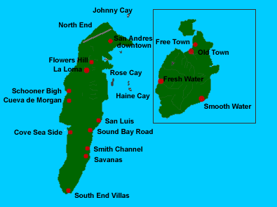
Main article: San Andrés (island)This is the main island of the San Andrés group, and the largest of the Departament. It is located at 12°33′N 81°43′W / 12.55°N 81.717°W. It measures 12 km in length with a width of 3 km and covers an area of 26 km². There is a tiny lagoon in the center of the island called Big Pond. The principal town is San Andrés in the north of the island. Another town is San Luis on the east coast. Cayo Johnny (Cayo Sucre) lies 1.5 km ENE of German Point (Punta Norte), the island's northern tip, and Haynes Cay about the same distance east of the island. Cotton Cay is less than 1 km south of San Andrés town, on the northeastern coast.
Cayos de Albuquerque (Cayos de S.W., Southwest Cays)
This atoll is southwest of San Andrés at 12°10′N 81°51′W / 12.167°N 81.85°W. It is the westernmost point of Colombia. The reef is about 7 km across. In the southern part are Cayo del Norte and Cayo del Sur. Cayo del Norte, the larger of the two, is up to 2 m high and overgrown with palm trees and bushes. Cayo del Sur, a few hundred metres further South, reaches a height of a little more than 1 m and is vegetated with a few bushes, and in the South with mangroves. There is a lighthouse on Cayo del Norte, at 12°10′N 81°50′W / 12.167°N 81.833°W, operating since 1980. It is maintained by the Colombian Navy.
Cayos del Este Sudeste (Courtown Cays, Cayos de E.S.E.)
 towns of San Andrés and Providencia
This atoll is 22 km east-south-east of San Andrés Island and 35 km northeast of Cayos de Alburquerque, at 12°24′N 81°28′W / 12.4°N 81.467°W. It is 14 km long and 4 km wide. There are a few sand cays in the southeast. The largest ones are Cayo del Este, Cayo Bolivar, West Cay, and Cayo Arena, none of which are higher than 2 metres. All cays are overgrown with palm trees and bushes, and surrounded by mangroves. There is a Colombian Navy lighthouse on Cayo Bolivar. The cays are regularly visited by fishermen from the Colombian mainland and San Andrés. There are two concrete buildings on Cayo Bolivar, and a few wooden huts on the other cays.
Municipality of Providencia y Santa Catalina (Providencia Archipelago)
Providencia Island (with Santa Catalina Island)
Main article: Providencia IslandThis is the main island of the Providencia group, and the second largest of the department. It is located at 13°21′N 81°22′W / 13.35°N 81.367°W. Providencia and Santa Catalina Island (a small satellite island close off its northern end) extend 7.2 km in a north-south direction. The land area of Providencia Island measures 17 km². The mountainous center of Providencia Island rises to three peaks of about the same elevation: roughly 363 meters. The island consists of sedimentary rocks laid down on a former volcano. The chief settlement is Santa Isabel Village aka 'Town' in the north, near Santa Catalina Island. Other villages are Lazy Hill on the west coast, and Bottom House in the southeast.
Low Cay, a very small islet, lies more than 10 km further north, at 13°32′N 81°21′W / 13.533°N 81.35°W.
Banks and Shoals
Colombia claims sovereignty over six additional outlying banks and shoals: Alice Shoal, Bajo Nuevo Bank, Serranilla Bank, Quita Sueño Bank, Serrana Bank, and Roncador Bank.
Demographics
Main article: RaizalBefore 1960, the population of the islands was almost entirely Raizals, who are an Afro-Caribbean group, Protestant in religion, speaking San Andrés-Providencia Creole. Colombia has promoted the migration of Spanish-speaking mainlanders, with Catholic missions participating since 1947. This policy seems to be an answer to growing discontent within the raizal community that could strengthen separatist movements; a raizal majority would in this case win a pro-independence referendum and could be neutralized by outnumbering them with immigrants.
By 2005, Raizals were only 30% of the 90,000 or more inhabitants of the islands, with the rest being mainland Colombians.[10] Raizals can speak both Spanish and English.
Transportation
Airports
The airport serves the cities of San Andrés and San Luis, but also commercially serves the nearby island of Providencia Island. All being major tourist and vacation spots for South and Central American tourists. Gustavo Rojas Pinilla International Airport is also known as Sesquicentenario International Airport. The airport is the 6th busiest airport in Colombia in terms of passengers, with 836,234 in 2006. Most of these passengers come from the continental part of the country, due to poor international direct service to the island. Many international tourists have to fly to one of Colombia's or Panama's largest airports (Bogotá, Medellín, Cali, Panama City) to be able to reach the islands. Although in recent years San Andrés has started to receive seasonal charter flights, mainly from Canada and a few Central American countries.
As of February 2011, there are no commercial passenger flights to San Andrés from Ecuador or Costa Rica. International travelers must fly to continental Colombia or to Panamá (one daily flight) to reach the island.
The airport is one of Colombia's fastest growing airports with a 13.4% increase in the number of passengers between 2005 and 2006.
The airport was the site of an Aires Colombia aircraft crash on August 16, 2010. The Boeing 737-700 left Bogota 2 hours before landing into bad weather with poor visibility condition. The crew reported a lightning strike that temporarily blinded the pilots on very short final. The plane broke up into three parts on the runway, all but 1 of the 126 passengers on board survived. The flight recorders have been removed from the wreckage and the exact causes of the crash are being investigated.
References
- ^ http://www.dane.gov.co/files/censo2005/regiones/sandres/sandres.pdf
- ^ Providence Island, 1630–1641, The Other Puritan Colony - by Karen Ordahl Kupperman, University of Connecticut
- ^ (Spanish) El Espectador: Colombia podría perder territorio, a pesar del fallo de la Haya
- ^ "Acquisition Process of Insular Areas". U.S. Department of the Interior, Office of Insular Affairs. http://www.doi.gov/oia/Islandpages/acquisition_process.htm. Retrieved 2008-01-13.
- ^ "FORMERLY DISPUTED ISLANDS". U.S. Department of the Interior, Office of Insular Affairs. http://www.doi.gov/oia/Islandpages/disputedpage.htm. Retrieved 2008-01-13.
- ^ "Raizales" (in Spanish). Fundación Hemera. Archived from the original on 2007-10-13. http://web.archive.org/web/20071013000210/http://www.etniasdecolombia.org/grupos_raizales.asp. Retrieved 2007-12-29.
- ^ Adelaida Cano Schütz (2005-05-09). "Los raizales sanandresanos: realidades étnicas y discurso político" (in Spanish). pasaporte colombiano. http://pasaportecolombiano.wordpress.com/2007/12/29/documento-acerca-de-los-raizales-de-san-andres/. Retrieved 2007-12-29.
- ^ Eduardo Lunazzi (2007-10-26). "Batalla publicitaria caracterizó la campaña en San Andrés" (in Spanish). El Tiempo. http://www.eltiempo.com/politica/2007-10-27/ARTICULO-WEB-NOTA_INTERIOR-3785822.html. Retrieved 2007-12-29.[dead link]
- ^ a b c Cesar Pizarro (2007-10-28). "Diputado Pedro Gallardo elegido Gobernador en voto finish" (in Spanish). The Archipielago Press. http://www.thearchipielagopress.com/content/view/516/5/. Retrieved 2007-12-29.
- ^ Fernando Urrea Giraldo (2007-10-12). "La visibilidad estadística de la población negra o afrodescendiente en Colombia, 1993-2005: entre lo étnico y lo racial" (in Spanish). 12º Congreso de Antropología, Universidad Nacional de Colombia. Archived from the original on 2008-02-27. http://web.archive.org/web/20080227200450/http://simposioraza.net/files/urrea.pdf. Retrieved 2007-12-29.
Sources
- Diemer, Christian; Šeparović, Amalija (2006). "Territorial Questions and Maritime Delimitation with Regard to Nicaragua’s Claims to the San Andrés Archipelago". Heidelberg Journal of International Law (HJIL) 66: 167–186. ISSN 00442348.
External links
- ICJ Nicaragua v. Colombia (Preliminary Objections) and (Merits) and 2007 Preliminary Objections Judgment and ASIL and BBC and Colombia President and Colombia MFA and Analysis 20 Hague YIL 75-119 2008
- [1] (English)
- Government Tourism website with small map
- San Andrés Website
- Off2Colombia - Information about San Andres
- Providencia information (English & Spanish)
- San Andrés & Providencia Website
- Tour Operator in the island, website with satellite map (Spanish)
- Tour Operator with Travel tips and must see in San Andrés in (en;es;de)
- Scuba diving information about San Andrés (Spanish)
- Information on some Atolls (German)
- Information on Colombian lighthouses (German)
- Oceandots
- New York Times article on independence movement
Departments of Colombia  Categories:
- San Andrés y Providencia
- Caribbean region of Colombia
- Departments of Colombia
- Caribbean islands of Colombia
- Islands of the West Caribbean
- Atolls of the North Atlantic Ocean
- Archipelagoes of the Caribbean Sea
- Biosphere reserves of Colombia
- States and territories established in 1991


Wikimedia Foundation. 2010.