- Norris Arm
-
Not to be confused with Norris Point, Newfoundland and Labrador.
Norris Arm — Town —
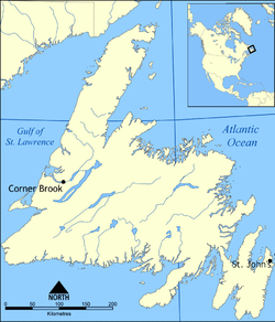
SealMotto: "The Town With The Sensational Sunset" Location of Norris Arm in Newfoundland Coordinates: 49°05′N 55°16′W / 49.083°N 55.267°W Country  Canada
Province  Newfoundland and Labrador
Census division 6 Settled 1700's Incorporated (town) 1971 Government – Type Norris Arm Town Council – Mayor Fred Budgell – MP Scott Simms (Liberal) – MHA Wade Verge (PC) Area – Total 41.49 km2 (16 sq mi) Elevation 22 m (72 ft) Population (2006)[1] – Total 911 – Density 22.0/km2 (57/sq mi) Time zone Newfoundland Time (UTC-3:30) – Summer (DST) Newfoundland Daylight (UTC-2:30) Postal Code Span A0G Area code(s) 709 Highways Route 1 Website Norris Arm official site Norris Arm is a town in north-central Newfoundland, Newfoundland and Labrador, Canada. It is in Division No. 6, on the Bay of Exploits.
According to the 2006 Statistics Canada Census:
- Population: 911
- % Change (2001–2006): approx. 8.1%
- Dwellings: 510
- Area (km²): 41.49
- Density (persons per km²): 22.0
See also
References
External links
North: Division No. 6, Subd. D West: Bay of Exploits Norris Arm East: Division No. 6, Subd. D South: Division No. 6, Subd. D  Subdivisions of Newfoundland and Labrador
Census divisions Cities Other communities Bishop's Falls · Bonavista · Botwood · Carbonear · Channel – Port aux Basques · Clarenville · Conception Bay South · Deer Lake · Ferryland · Fogo · Gander · Grand Bank · Grand Falls-Windsor · Happy Valley – Goose Bay · Harbour Grace · Hopedale · Labrador City · Marystown · Nain · Norris Arm · Pasadena · Peterview · Placentia · Red Bay · St. Anthony · Stephenville · Twillingate · Torbay · Woody Point · Makkovik Category:Newfoundland and Labrador ·
  Portal:Newfoundland and Labrador ·
  WikiProject:Newfoundland and Labrador
Coordinates: 49°05′N 55°16′W / 49.083°N 55.267°W
Categories:- Populated coastal places in Canada
- Towns in Newfoundland and Labrador
- Newfoundland and Labrador geography stubs
Wikimedia Foundation. 2010.


