|
Landmark name |
Image |
Date listed |
Location |
Summary |
| 1 |
Benjamin Adams House |
 |
01983-10-07 October 7, 1983 |
81 N. Main St.
42°4′49″N 71°38′3″W / 42.08028°N 71.63417°W / 42.08028; -71.63417 (Adams, Benjamin, House) |
|
| 2 |
E. Albee House |
|
01983-10-07 October 7, 1983 |
Highland St.
42°4′7″N 71°35′42″W / 42.06861°N 71.595°W / 42.06861; -71.595 (Albee, E., House) |
|
| 3 |
Daniel Aldrich Cottage and Sawmill |
|
01983-10-07 October 7, 1983 |
Aldrich St.
42°1′38″N 71°38′35″W / 42.02722°N 71.64306°W / 42.02722; -71.64306 (Aldrich, Daniel, Cottage and Sawmill) |
|
| 4 |
J. Aldrich House |
|
01984-01-20 January 20, 1984 |
Aldrich St.
42°1′38″N 71°38′35″W / 42.02722°N 71.64306°W / 42.02722; -71.64306 (Aldrich, J., House) |
|
| 5 |
S. Aldrich House |
|
01983-10-07 October 7, 1983 |
Aldrich St.
42°1′44″N 71°38′17″W / 42.02889°N 71.63806°W / 42.02889; -71.63806 (Aldrich, S., House) |
|
| 6 |
W. Aldrich House |
|
01983-10-07 October 7, 1983 |
Henry St.
42°4′50″N 71°36′3″W / 42.08056°N 71.60083°W / 42.08056; -71.60083 (Aldrich, W., House) |
|
| 7 |
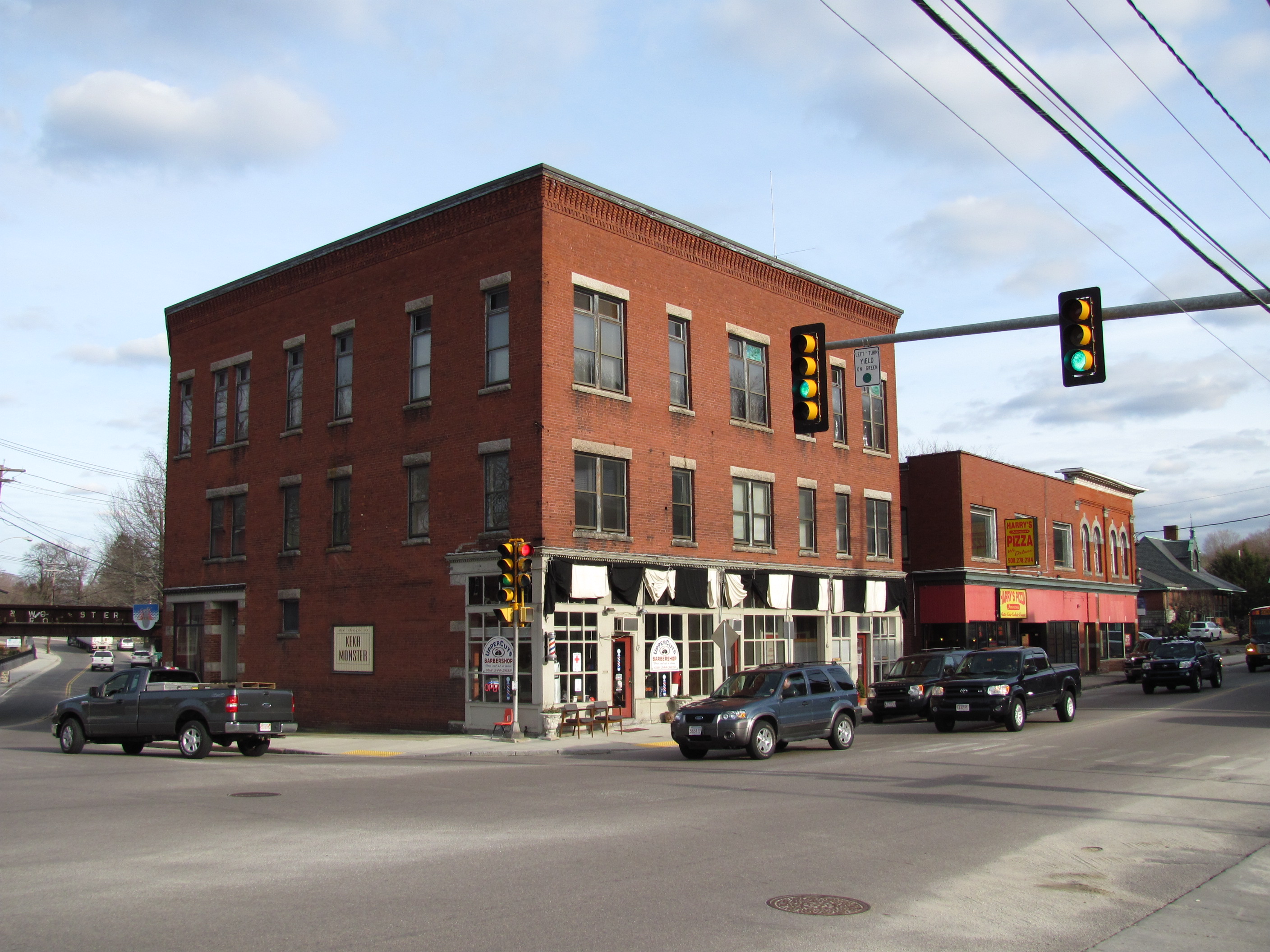
Bank Building |
 |
01983-10-07 October 7, 1983 |
40-44 S. Main St.
42°4′30″N 71°37′43″W / 42.075°N 71.62861°W / 42.075; -71.62861 (Bank Building) |
|
| 8 |
Blackstone Canal |
 |
01973-02-06 February 6, 1973 |
East of MA 122 between Northbridge and Uxbridge
42°5′31″N 71°37′46″W / 42.09194°N 71.62944°W / 42.09194; -71.62944 (Blackstone Canal) |
Extends into Northbridge |
| 9 |
Blackstone Canal Historic District |
 |
01995-08-15 August 15, 1995 |
Address Restricted
42°8′39″N 71°40′36″W / 42.14417°N 71.67667°W / 42.14417; -71.67667 (Blackstone Canal Historic District) |
|
| 10 |
E. Brown House |
|
01983-10-07 October 7, 1983 |
3 Sutton St.
42°5′24″N 71°39′0″W / 42.09°N 71.65°W / 42.09; -71.65 (Brown, E., House) |
|
| 11 |
Butler Block |
|
01983-10-07 October 7, 1983 |
210 Linwood St.
42°5′48″N 71°38′41″W / 42.09667°N 71.64472°W / 42.09667; -71.64472 (Butler Block) |
|
| 12 |
Charles Capron House |
|
01983-10-07 October 7, 1983 |
2 Capron St.
42°4′40″N 71°37′39″W / 42.07778°N 71.6275°W / 42.07778; -71.6275 (Capron, Charles, House) |
|
| 13 |
George Carpenter House |
 |
01983-10-07 October 7, 1983 |
67 S. Main St.
42°4′25″N 71°37′42″W / 42.07361°N 71.62833°W / 42.07361; -71.62833 (Carpenter, George, House) |
|
| 14 |
Central Woolen Mills District |
 |
01984-01-20 January 20, 1984 |
Mendon and Cross Sts.
42°4′49″N 71°37′16″W / 42.08028°N 71.62111°W / 42.08028; -71.62111 (Central Woolen Mills District) |
|
| 15 |
A. Chapin House |
|
01983-10-07 October 7, 1983 |
26 Pleasant St.
42°4′28″N 71°37′49″W / 42.07444°N 71.63028°W / 42.07444; -71.63028 (Chapin, A., House) |
|
| 16 |
A. E. Cook House |
|
01983-10-07 October 7, 1983 |
Aldrich St.
42°1′56″N 71°37′46″W / 42.03222°N 71.62944°W / 42.03222; -71.62944 (Cook, A. E., House) |
|
| 17 |
Francis Deane Cottage |
|
01983-10-07 October 7, 1983 |
58 N. Main St.
42°4′43″N 71°37′57″W / 42.07861°N 71.6325°W / 42.07861; -71.6325 (Deane, Francis, Cottage) |
|
| 18 |
Farnum Block |
|
01983-10-07 October 7, 1983 |
2-6 N. Main St.
42°4′34″N 71°37′49″W / 42.07611°N 71.63028°W / 42.07611; -71.63028 (Farnum Block) |
|
| 19 |
Coronet John Farnum House |
 |
01980-05-07 May 7, 1980 |
Mendon St.
42°4′37″N 71°37′41″W / 42.07694°N 71.62806°W / 42.07694; -71.62806 (Farnum, Coronet John, House) |
|
| 20 |
Moses Farnum House |
 |
01983-10-07 October 7, 1983 |
MA 146
42°2′27″N 71°37′20″W / 42.04083°N 71.62222°W / 42.04083; -71.62222 (Farnum, Moses, House) |
|
| 21 |
R. Farnum House |
|
01983-10-07 October 7, 1983 |
20 Oak St.
42°4′46″N 71°37′33″W / 42.07944°N 71.62583°W / 42.07944; -71.62583 (Farnum, R., House) |
|
| 22 |
William and Mary Farnum House |
 |
01984-01-20 January 20, 1984 |
4 Albee Rd.
42°2′42″N 71°36′30″W / 42.045°N 71.60833°W / 42.045; -71.60833 (Farnum, William and Mary, House) |
|
| 23 |
Friends Meetinghouse |
 |
01974-01-24 January 24, 1974 |
South of Uxbridge on MA 146
42°2′21″N 71°37′16″W / 42.03917°N 71.62111°W / 42.03917; -71.62111 (Friends Meetinghouse) |
|
| 24 |
Granite Store |
|
01983-10-07 October 7, 1983 |
112-116 Hecla St.
42°4′28″N 71°36′47″W / 42.07444°N 71.61306°W / 42.07444; -71.61306 (Granite Store) |
|
| 25 |
S.A. Hall House |
|
01983-10-07 October 7, 1983 |
133 N. Main St.
42°4′54″N 71°38′16″W / 42.08167°N 71.63778°W / 42.08167; -71.63778 (Hall, S.A., House) |
|
| 26 |
William Hayward House |
|
01983-10-07 October 7, 1983 |
77 N. Main St.
42°4′48″N 71°38′2″W / 42.08°N 71.63389°W / 42.08; -71.63389 (Hayward, William, House) |
|
| 27 |
Sylvanus Holbrook House |
|
01983-10-07 October 7, 1983 |
Albee Rd.
42°2′41″N 71°36′35″W / 42.04472°N 71.60972°W / 42.04472; -71.60972 (Holbrook, Sylvanus, House) |
|
| 28 |
Ironstone Mill Housing and Cellar Hole |
 |
01983-10-07 October 7, 1983 |
Ironstone St.
42°1′38″N 71°36′34″W / 42.02722°N 71.60944°W / 42.02722; -71.60944 (Ironstone Mill Housing and Cellar Hole) |
|
| 29 |
Judson-Taft House |
|
01983-10-07 October 7, 1983 |
30 Pleasant St.
42°4′29″N 71°37′49″W / 42.07472°N 71.63028°W / 42.07472; -71.63028 (Judson-Taft House) |
|
| 30 |
J. Kensely House |
|
01983-10-07 October 7, 1983 |
Chestnut St.
42°1′41″N 71°37′32″W / 42.02806°N 71.62556°W / 42.02806; -71.62556 (Kensely, J., House) |
|
| 31 |
North Uxbridge School |
 |
01983-10-07 October 7, 1983 |
87 E. Hartford Ave.
42°5′31″N 71°38′21″W / 42.09194°N 71.63917°W / 42.09194; -71.63917 (North Uxbridge School) |
|
| 32 |
Dexter Richardson House |
|
01983-10-07 October 7, 1983 |
South St.
42°1′29″N 71°36′52″W / 42.02472°N 71.61444°W / 42.02472; -71.61444 (Richardson, Dexter, House) |
|
| 33 |
Joseph Richardson House |
|
01983-10-07 October 7, 1983 |
Chockalog St.
42°1′47″N 71°40′21″W / 42.02972°N 71.6725°W / 42.02972; -71.6725 (Richardson, Joseph, House) |
|
| 34 |
Rivulet Mill Complex |
|
01983-10-07 October 7, 1983 |
60 Rivulet St.
42°5′15″N 71°38′40″W / 42.0875°N 71.64444°W / 42.0875; -71.64444 (Rivulet Mill Complex) |
|
| 35 |
Richard Sayles House |
|
01983-10-07 October 7, 1983 |
80 Mendon St.
42°4′47″N 71°33′51″W / 42.07972°N 71.56417°W / 42.07972; -71.56417 (Sayles, Richard, House) |
|
| 36 |
Rogerson's Village Historic District |
 |
01971-11-23 November 23, 1971 |
Northern and southern sides of Hartford Ave.
42°5′34″N 71°38′11″W / 42.09278°N 71.63639°W / 42.09278; -71.63639 (Rogerson's Village Historic District) |
|
| 37 |
Elisha Southwick House |
|
01983-10-07 October 7, 1983 |
Chockalog St.
42°2′22″N 71°38′45″W / 42.03944°N 71.64583°W / 42.03944; -71.64583 (Southwick, Elisha, House) |
|
| 38 |
Israel Southwick House |
|
01983-10-07 October 7, 1983 |
70 Mendon St.
42°4′42″N 71°37′33″W / 42.07833°N 71.62583°W / 42.07833; -71.62583 (Southwick, Israel, House) |
|
| 39 |
Taft Brothers Block |
 |
01983-10-07 October 7, 1983 |
2-8 S. Main St.
42°4′34″N 71°37′47″W / 42.07611°N 71.62972°W / 42.07611; -71.62972 (Taft Brothers Block) |
|
| 40 |
Aaron Taft House |
|
01983-10-07 October 7, 1983 |
Hazel St.
42°4′47″N 71°39′7″W / 42.07972°N 71.65194°W / 42.07972; -71.65194 (Taft, Aaron, House) |
|
| 41 |
Bazaleel Taft, Jr. House and Law Office |
 |
01983-10-07 October 7, 1983 |
147 S. Main St.
42°4′1″N 71°37′26″W / 42.06694°N 71.62389°W / 42.06694; -71.62389 (Taft, Bazaleel, Jr., House and Law Office) |
|
| 42 |
George Taft House |
|
01983-10-07 October 7, 1983 |
Richardson St.
42°3′40″N 71°38′18″W / 42.06111°N 71.63833°W / 42.06111; -71.63833 (Taft, George, House) |
|
| 43 |
Hon. Bazaleel Taft House |
 |
01983-10-07 October 7, 1983 |
S. Main St.
42°4′0″N 71°36′39″W / 42.066667°N 71.61083°W / 42.066667; -71.61083 (Taft, Hon. Bazaleel, House) |
|
| 44 |
Moses Taft House |
|
01983-10-07 October 7, 1983 |
66 S. Main St.
42°4′27″N 71°37′41″W / 42.07417°N 71.62806°W / 42.07417; -71.62806 (Taft, Moses, House) |
|
| 45 |
Samuel Taft House |
|
01983-10-07 October 7, 1983 |
Sutton St.
42°5′28″N 71°39′21″W / 42.09111°N 71.65583°W / 42.09111; -71.65583 (Taft, Samuel, House) |
|
| 46 |
Zadock Taft House |
|
01983-10-07 October 7, 1983 |
112 S. Main St.
42°4′14″N 71°37′34″W / 42.07056°N 71.62611°W / 42.07056; -71.62611 (Taft, Zadock, House) |
|
| 47 |
C.R. Thomson House and Barn |
|
01983-10-07 October 7, 1983 |
Chockalog St.
42°1′57″N 71°40′47″W / 42.0325°N 71.67972°W / 42.0325; -71.67972 (Thomson, C.R., House and Barn) |
|
| 48 |
Uxbridge Common District |
 |
01984-01-20 January 20, 1984 |
Main, Court, and Douglas Sts.
42°4′38″N 71°37′53″W / 42.07722°N 71.63139°W / 42.07722; -71.63139 (Uxbridge Common District) |
|
| 49 |
Uxbridge Passenger Depot |
|
01983-10-07 October 7, 1983 |
28 S. Main St.
42°4′32″N 71°37′44″W / 42.07556°N 71.62889°W / 42.07556; -71.62889 (Uxbridge Passenger Depot) |
|
| 50 |
Uxbridge Town Hall |
 |
01983-10-07 October 7, 1983 |
45 S. Main St.
42°4′31″N 71°37′46″W / 42.07528°N 71.62944°W / 42.07528; -71.62944 (Uxbridge Town Hall) |
|
| 51 |
Waucantuck Mill Complex |
|
01984-01-20 January 20, 1984 |
Mendon and Patrick Henry Sts.
42°4′57″N 71°36′31″W / 42.0825°N 71.60861°W / 42.0825; -71.60861 (Waucantuck Mill Complex) |
|
| 52 |
Wheelockville District |
|
01984-01-20 January 20, 1984 |
Mendon and Henry Sts.
42°4′51″N 71°36′47″W / 42.08083°N 71.61306°W / 42.08083; -71.61306 (Wheelockville District) |
|
| 53 |
A. Whipple House |
|
01983-10-07 October 7, 1983 |
Sutton St.
42°5′54″N 71°40′35″W / 42.09833°N 71.67639°W / 42.09833; -71.67639 (Whipple, A., House) |
|
| 54 |
N. Williams House |
|
01983-10-07 October 7, 1983 |
Rawson St.
42°5′24″N 71°40′38″W / 42.09°N 71.67722°W / 42.09; -71.67722 (Williams, N., House) |
|