- Missoula Metropolitan Area
-
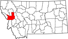 Location of the Missoula Metropolitan Statistical Area in Montana
The Missoula Metropolitan Statistical Area is located in the West-central portion of the state, the 2010 census put its population at 109,299 making it the 2nd largest metropolitan statistical area in Montana and the 331st largest in the nation between Decatur, Illinois and Bismarck, North Dakota.[1]
It is one of the largest metropolitan areas between Boise, Idaho and Calgary, Alberta Canada and Coeur d'Alene, Idaho[2]and Billings, Montana.
Contents
Counties
Communities
Places with more than 66,000 inhabitants
- Missoula (principal city)
Places with 1,000 to 10,000 inhabitants
- Bonner-West Riverside (Census-designated place)
- East Missoula (Census-designated place)
- Lolo (Census-designated places)
- Orchard Homes (Census-designated places)
- Seeley Lake (Census-designated place)
Places with 500 to 1,000 inhabitants
- Clinton (Census-designated place)
- Frenchtown (Census-designated place)
- Wye (Census-designated place)
Unincorporated places
- Condon (Unincorporated place)
- Lolo Hot Springs, Montana (Unincorporated place)
Ghost Town(s)
Demographics
As of the census[3] of 2000, there were 95,802 people, 38,439 households, and 23,140 families residing in the county. The population density was 37 people per square mile (14/km²). There were 41,319 housing units at an average density of 16 per square mile (6/km²). The racial makeup of the county was:
- 94.02% White
- 0.27% Black or African American
- 2.29% Native American
- 1.02% Asian
- 0.08% Pacific Islander
- 0.45% from other races
- 1.86% from two or more races.
Historical Populations
Census Pop. %± 1870 2,554 - 1880 2,537 -0.7% 1890 14,427 468.7% 1900 13,964 −3.2% 1910 23,596 69.0% 1920 24,041 1.9% 1930 21,782 −9.4% 1940 29,038 33.3% 1950 35,493 22.2% 1960 44,663 25.8% 1970 58,263 30.5% 1980 76,016 30.5% 1990 78,687 3.5% 2000 95,802 21.8% 2010 109,299 14.1% See also
References
- ^ "Table 1. Annual Estimates of the Population of Metropolitan and Micropolitan Statistical Areas: April 1, 2000 to July 1, 2009 (CBSA-EST2009-01)" (CSV). 2009 Population Estimates. United States Census Bureau, Population Division. 2010-03-23. http://www.census.gov/popest/metro/tables/2009/CBSA-EST2009-01.csv.
- ^ http://quickfacts.census.gov/qfd/states/16/16055.html
- ^ http://factfinder.census.gov/ retrieved 2010-09-01
 State of Montana
Helena (capital) Topics Index · History · Governors · People · Geography · State Government · Delegations · Visitor Attractions
Society Crime · Demographics · Economy · Education · Politics
Regions The Flathead · Glacier National Park · Regional designations of Montana · Western Montana · Yellowstone
Largest cities Counties Beaverhead · Big Horn · Blaine · Broadwater · Carbon · Carter · Cascade · Chouteau · Custer · Daniels · Dawson · Deer Lodge · Fallon · Fergus · Flathead · Gallatin · Garfield · Glacier · Golden Valley · Granite · Hill · Jefferson · Judith Basin · Lake · Lewis and Clark · Liberty · Lincoln · Madison · McCone · Meagher · Mineral · Missoula · Musselshell · Park · Petroleum · Phillips · Pondera · Powder River · Powell · Prairie · Ravalli · Richland · Roosevelt · Rosebud · Sanders · Sheridan · Silver Bow · Stillwater · Sweet Grass · Teton · Toole · Treasure · Valley · Wheatland · Wibaux · Yellowstone
Categories:

Wikimedia Foundation. 2010.