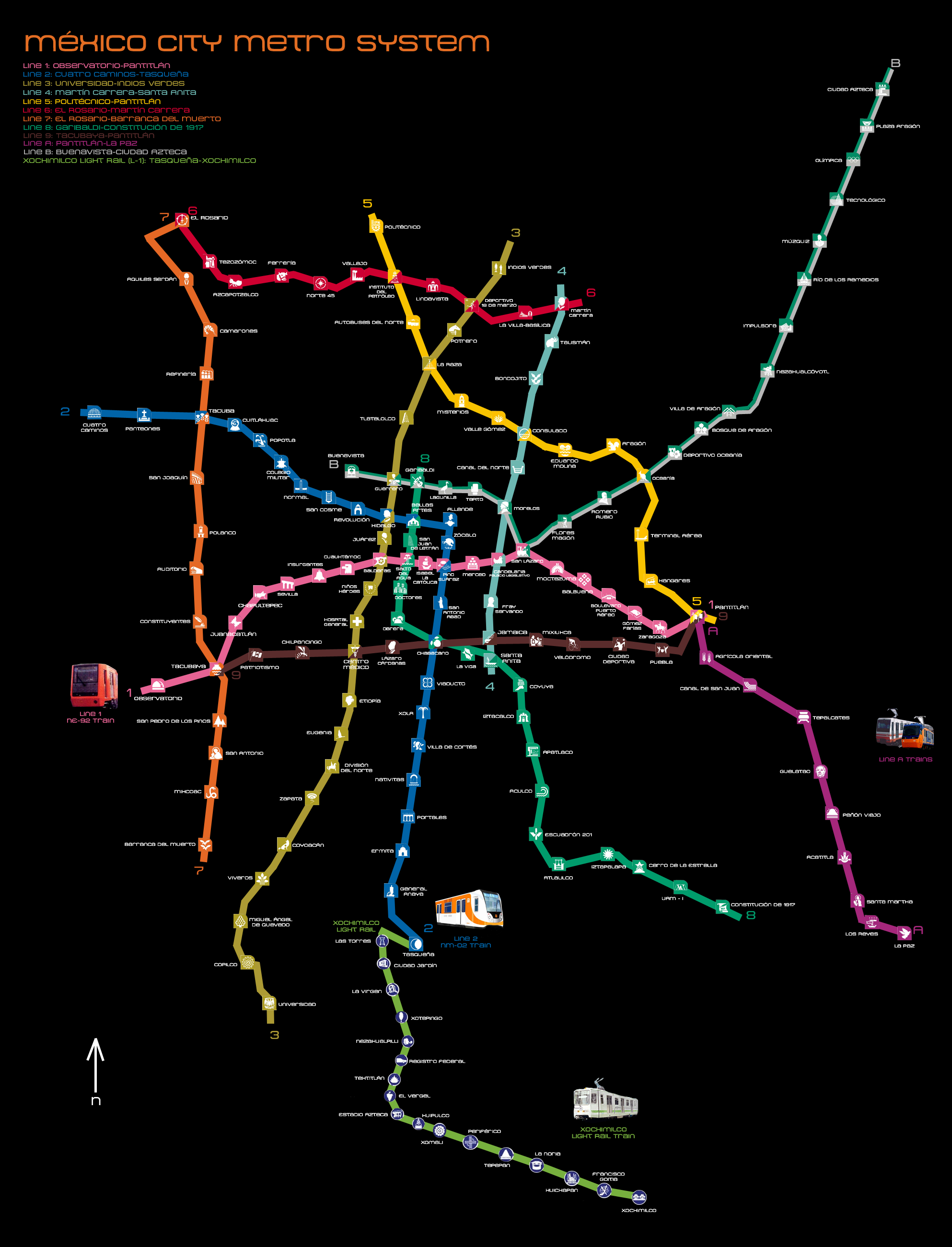
- Mexico City metro lines
-

Presented below the lines within the Mexico City Metro system, as of 2006[update], organized by number. The order in which they are listed follows the convention used by Sistema de Transporte Colectivo (the public company that manages the system) to list the stations in north-south and west-east fashion. This system however may not be used by other sources.
In addition to listing all current 175 stations, the opening date of each one of them is also provided, including their type of construction, which can fit in one of three categories: underground, surface ("street-level") and elevated (in form of an elevated viaduct). In total, 107 stations are under ground, 52 are located on street-level and 16 are elevated.
Line 1

The first section of line 1 was the first to be opened in the system, in 1969. After four expansions, the line currently has 20 stations over a total track length of 18.828 km, of which 16.654 km are passenger track. The line has a general east-west direction passing through the city center and its color is pink.
It is the only line in the system where all stations run underground, and although a section of the track past the Observatorio terminal is located on the street-level, it is only used for train maintenance. Six stations connect with other metro lines. Line 1 is served by MP-68 trains, built in France in 1968 and NE-92 trains, built in Spain in 1992.
The line is built under several avenues: Parque Lira, Pedro Antonio de los Santos, Circuito Interior, Avenida de los Insurgentes, Avenida Chapultepec, Arcos de Belén, Balderas, Eje Central Lázaro Cárdenas, José María Izazaga, Isabel la Católica, Anillo de Circunvalación, Congreso de la Unión, Eduardo Molina, and Ignacio Zaragoza, it commutes with Line 7 and 9 at the Station Tacubaya, Line 3 at Balderas, Line 8 at Salto del Agua, Line 2 at Pino Suárez, Line 4 at Candelaria, Line B at San Lázaro and Lines 5, 9 and A at Pantitlán.
Station Logo Opening date Station type Observatorio Observatory June 10, 1971 Underground Tacubaya Water bowl November 20, 1970 Juanacatlán Butterfly April 11, 1970 Chapultepec Grasshopper September 4, 1969 Sevilla Aqueduct Insurgentes Bell Cuauhtémoc Eagle head Balderas Cannon Salto del Agua Fountain Isabel la Católica Caravel Pino Suárez Aztec shrine Merced Huacal Basket with fruit Candelaria Duck San Lázaro Locomotive Moctezuma Moctezuma plume headdress Balbuena Four flowers Boulevard Puerto Aéreo A Brige Gómez Farías Constitution of 1857 Zaragoza Ignacio Zaragoza and horse Pantitlán Two flags August 22, 1984 Line 2: Cuatro Caminos – Tasqueña

Line 2 was second line in the system to open, in 1970. After two expansions, the line has 24 stations over a total track length of 23.431 km, of which 20.713 km are passenger track. The line has a general northwest-south direction passing through the city center and its color is blue. It starts at the border of the Federal District and the State of Mexico and ends in the city south.
It commutes with Line 7 at Tacuba, Line 3 at Hidalgo, Line 8 at Bellas Artes, Line 1 at Pino Suárez and Lines 8 and 9 at Chabacano. At Tasqueña it links with the Mexico City Light Rail to Xochimilco. It used to be served by NC-82 and some NM-83 trains.
This line was temporarily served by a NM-02 train with landscapes and images of Mexico City.
Line 2 was the scene of the worst accident in Mexico City history on October 20, 1975, when a crash occurred between two trains at the Viaducto Station. One train was parked at the station picking up passengers when it was hit by another train that did not stop in time. 20 people were killed and several wounded. After that accident, automatic traffic lights were installed in all the lines.
Thirteen stations run underground while the remaining ten are surface stations. Five stations connect with other metro lines. The line is served by NM-02 trains built in Mexico in 2004.
Station Logo Date opened Station type Cuatro Caminos The "Toreo de 4 caminos" silhouette August 22, 1984 Underground Panteones Grave Tacuba Flowers September 14, 1970 Cuitláhuac An Aztec shield Popotla The "Night of Sorrows" tree Colegio Militar the "Colegio Militar" coat of arms Normal The "Casco de Santo Tomas" bldg. San Cosme The "Casa de los Mascarones" facade Revolución Revolution Memorial Hidalgo Miguel Hidalgo Bellas Artes Bellas Artes building Allende Ignacio Allende Zócalo Mexican coat of arms Pino Suárez An Aztec Shrine August 1, 1970 San Antonio Abad San Antonio Abad Surface Chabacano Apricot Viaducto Road intersection Xola Palm tree Villa de Cortés Conquistador helmet Nativitas Chinampa Portales Three archs Ermita Church General Anaya A cannon and Pedro María Anaya Tasqueña Quarter moon Line 3: Indios Verdes – Universidad
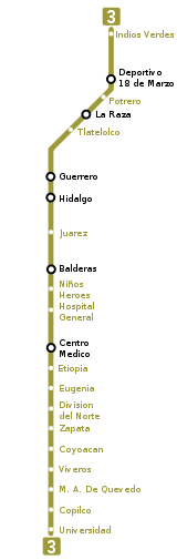
The first section of line 3 was opened in 1970. It has been expanded five times to comprise 21 stations over a total track length of 23.609 km, of which 21.278 are passenger track, making it the longest of the system. The line has a general north-south direction passing through the western end of downtown Mexico City and its color is olive green.
It is built under Avenida de los Insurgentes, Guerrero, Zarco, Balderas, Cuauhtémoc, Universidad, Copilco and Delfín Madrigal avenues. It commutes with Line 6 at Deportivo 18 de Marzo, Line 5 at La Raza, Line B at Guerrero, Line 2 at Hidalgo, Line 1 at Balderas and Line 9 at Centro Médico.
Most of the stations (17) run underground with the remaining four, including both terminals, being surface stations. Six stations connect with other metro lines.

Line color olive green Passenger railway length 21.278 km Total railway length 23.609 km Rolling stock NM-79 trains made in Mexico in 1979 Stations 21 Type of line Universidad is a superficial terminal.
From Copilco to La Raza, underground.
From Potrero to Indios Verdes, combines superficial platforms with underground passenger passages.Direction North-South, though the city center Started operations November 20, 1970: from Tlatelolco to Hospital General
August 25, 1978: from Tlatelolco to La Raza
December 1, 1979: from La Raza to Indios Verdes
June 7, 1980: from Hospital General to Centro Médico
August 25, 1980: from Centro Médico to Zapata
August 30, 1983: from Zapata to UniversidadStation Logo Date opened Station type Indios Verdes "Green indians" monument December 1, 1979 Surface Deportivo 18 de Marzo Aztec ball game player Potrero Horse La Raza Pyramid August 25, 1978 Underground Tlatelolco The "Banobras" building silhouette November 20, 1970 Guerrero Vicente Guerrero silhouette Hidalgo Miguel Hidalgo Juárez Benito Juárez Balderas Cannon Niños Héroes a Kepi (military hat) Hospital General Cross Centro Médico a caduceus June 7, 1980 Etiopía / Plaza de la Transparencia Lion August 25, 1980 Eugenia A Stork División del Norte Francisco Villa and horse Zapata Emiliano Zapata Coyoacán Coyote August 30, 1983 Viveros / Derechos Humanos the silhouette of a plant Miguel Ángel de Quevedo Tree Copilco Sun Universidad UNAM coat of arms Surface Line 4: Santa Anita – Martín Carrera
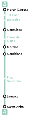
The first section of line 4 was opened in 1981, and it was expanded once to bring the total extension of this line to ten stations over 10.747 km of track, of which 9.363 km are passenger track. The line has a general north-south direction and is located east of the city center and its color is aqua. It is also the line with the lowest passenger flow, which is why the STC introduced modified 6-wagon-trains. In the original blueprint, this line was planned to extend to the north all the way to Ecatepec, Mexico State.
Line 4 is the only one in the system that does not have underground sections. Eight of the ten stations are built on an elevated viaduct and the remaining two are surface stations. Additionally, six stations connect with other metro lines. It connects with Lines 1 at Candelaria, Line 6 at Martín Carrera, Line 5 at Consulado, Line 8 at Santa Anita, Line 9 at Jamaica and Line B at Morelos.

Line color light blue Passenger railway length 9.363 km Total railway length 10.747 km Rolling stock Six-wagon trains built in Spain by C.A.F. Stations 10 Type of line 8 elevated viaduct stations and 2 surface stations Direction North-South, on the east side of the city Started operations August 29, 1981: from Martín Carrera to Candelaria
May 26, 1982: from Candelaria to Santa AnitaStation Logo Date opened Station type Martín Carrera Martín Carrera August 29, 1981 Surface Talismán Mamooth Elevated Bondojito Nopal Consulado A trasversal section of a water duct Canal del Norte A tranversal section af a water way Morelos José María Morelos Candelaria Duck Surface Fray Servando Servando Teresa de Mier May 26, 1982 Elevated Jamaica An ear of corn Santa Anita A man sailing in a canoe Line 5: Politécnico – Pantitlán
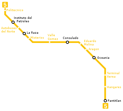
The first section of line 5 was opened in 1981, and it has been expanded twice to bring the total extension of this line to 13 stations over 15.675 km of track, of which 14.435 km are passenger track. The line has a general north-west to south-east direction relative to the city center and its color is yellow. This line previously had the NM73 trains but due to the introduction of the NM02 trains in Line 2 now it is served by NC82 Canadian trains made by Bombardier. Line 5 runs to Mexico City International Airport (Terminal Aérea station).
Line 5 has four underground and nine surface stations. Five stations connect with other metro lines.

Line color yellow Rolling stock NC-82 trains made in Canada in 1982 Passenger railway length 14.435 km Total railway length 15.675 km Stations 13 Type of line From Politécnico to La Raza, superficial with underground access.
Misterios and Valle Gómez, underground
From Consulado to Oceanía, superficial with underground access
Terminal Aérea and Hangares, underground and
Pantitlán is superficial.Direction North-East Started operations December 19, 1981: from Pantitlán to Consulado
July 1, 1982: from Consulado to La Raza
August 30, 1982: from La Raza to PolitécnicoStation Logo Date opened Station type Politécnico IPN coat of arms August 30, 1982 Surface Instituto del Petróleo A petroleum tower Autobuses del Norte Foreign Bus La Raza Pyramid July 1, 1982 Misterios a "Misterios" Monument Underground Valle Gómez Agave plant Consulado Transversal cut uf a duct of water December 19, 1981 Surface Eduardo Molina Hands holding water Aragón Squirrel Oceanía Kangaroo Terminal Aérea Aerial control tower and a plane Underground Hangares Biplane Pantitlán Two Flags Surface Line 6: El Rosario – Martín Carrera
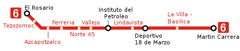
Line 6 had its first section inaugurated in 1983. It has been expanded once to bring the total extension of the line to 11 stations over 13.947 km of track, of which 11.434 are passenger track. This line has a west-east direction running north of the city center and its color is scarlet red.
The line has only one surface station, the El Rosario terminal, while the rest of the line runs under ground. Four stations connect with other metro lines. Line 6, like line 4, is also served by customized six-car trains.

Line color red Passenger railway length 11.434 km Total railway length 13.947 km Rolling stock due to the low volume of persons in the line, the STC introduced six-wagon trains Stations 11 Type of line El Rosario is a superficial terminal.
From Tezozomoc to Martín Carrera, underground.Direction West-East, in the city north Started operations December 21, 1983: from El Rosario to Instituto del Petróleo
July 8, 1986: from Instituto del Petróleo to Martín CarreraStation Logo Date opened Station type El Rosario A Rosary December 21, 1983 Surface Tezozomoc Tezozomoc Underground Azcapotzalco Ant Ferrería A Cow Head Norte 45 A windrose Vallejo A factory Instituto del Petróleo A petroleum tower Lindavista San Cayetano church July 8, 1986 Deportivo 18 de Marzo Aztec ball game player La Villa-Basílica Basílica de Guadalupe and Guadalupe virgin Martín Carrera Martín Carrera Line 7: El Rosario – Barranca del Muerto
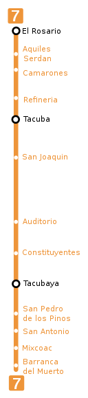
The first section of line 7 was opened to the public in 1984. It has been expanded three times to bring the total length of the line to 14 stations over 18.784 km of track, of which 17.011 km are passenger track. Line 7 has a north-south direction running west of the city center and its color is orange.
The line has its only surface station in the El Rosario terminal. The rest of the line runs under ground, with some sections being located more than 20 m below street-level, making it the deepest line in the system at a maximum of 36 meters. Three stations connect with other metro lines.
This line used MP68 trains and a small number of NM73, after the rehabilitation of some MP68. They kept circulating on this line although there is a slightly bigger number of NM79 and NM83 in this line. Today there are only retroadapted NM73 and NM83 models and some trains from the first model due to the introduction of the NM02 in the Line 2. Currently the MP68 Trains from Line 9 are being reintroduced.

Line color orange Passenger railway length 17.011 km Total railway length 18.784 km Stations 14 Type of line El Rosario is a surface terminal.
From Aquiles Serdán to Barranca del Muerto, stations are underground.Direction North-South, at the city west Started operations December 20, 1984: from Tacuba to Auditorio
August 22, 1985: from Auditorio to Tacubaya
December 19, 1985: from Tacubaya to Barranca
December 29, 1988: from Tacuba to El RosarioStation Logo Date opened Station type El Rosario A Rosary December 29, 1988 Surface Aquiles Serdán Aquiles Serdán Underground Camarones A shrimp Refinería A PEMEX refinery container Tacuba Flowers December 20, 1984 San Joaquín Bridge Polanco A Clock Tower Auditorio Auditorio building Constituyentes A book, ink and a Feather August 22, 1985 Tacubaya A Water bowl San Pedro de los Pinos Two Pines December 19, 1985 San Antonio San Antonio and a kid Mixcoac A snake Barranca del Muerto Two Eagles Line 8: Garibaldi / Lagunilla – Constitución de 1917
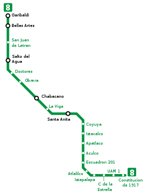
Line 8 was the next to last route of the network to be opened, on July 20, 1994 by then President Carlos Salinas de Gortari and then regent of the city, Manuel Aguilera Gómez. Construction plans for the line date back to much earlier, but they were put on hold due to significant redevelopment. It has 19 stations over a total track length of 20.078 km, of which 16.679 are passenger track. Line 8 runs in a general south-east direction, beginning near the city center, and its color is bright green. The line has 14 underground stations and five surface stations, including the southern terminal Constitución de 1917. Five stations connect line 8 with other metro lines. According to the Sistema de Transporte Colectivo, the volume of people moved in this line was 117,386,342 persons in 2006.

Line color green Passenger railway length 16.679 km Total railway length: 20.078 km Rolling stock MP82 trains made in France between 1982 and 1984 Stations 19 Direction Center-Southeast Started operations July 20, 1994 Station Logo Date opened Station type Garibaldi / Lagunilla A guitar and a sarape July 20, 1994 Underground Bellas Artes Bellas Artes builging San Juan de Letrán Latinoamerican Tower Salto del Agua Fountain Doctores Two doctors Obrera A helmet and two gears Chabacano Apricot La Viga Two Fish Santa Anita A man sailing in a canoe Coyuya A foot Surface Iztacalco San Matias Church Apatlaco An aztec temple with boiling water Aculco A Wave Escuadrón 201 Escuadron 201 logo Underground Atlalilco A water well Iztapalapa A Sun Cerro de la Estrella A hil with three crosses and a star UAM-I UAM coat of arms Constitución de 1917 Pergamin with a feather writing 1917 Surface Line 9: Tacubaya – Pantitlán
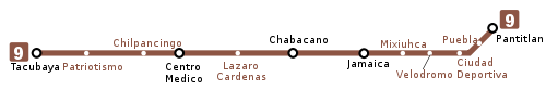
The first section of line 9 was opened to the public in 1987. It has been expanded once to a length of 12 stations over 15.375 km of track, of which 13.033 are passenger track. The line was opened to relieve passenger traffic from line 1, to which it runs parallel south of the city center. The color of the line is dark brown.
Line 9 has eight underground stations with the remaining being elevated stations similar to those in line 4, including the terminal Pantitlán. It is the only line in the system in which no section of the track runs at street-level. Additionally, five stations connect with other metro lines. The trains of this line are made up from MP68 trains rehabilitated with fans and intelligent control systems and some NM79 rolling stock.

Line color brown Passenger railway length 13.033 km Total railway length 15.375 km Station 12 Direction West-East, through the city center Started operations August 26, 1987: from Pantitlán to Centro Médico
August 29, 1988: from Centro Médico to TacubayaStation Logo Date opened Station type Tacubaya A Water bowl August 29, 1988 Underground Patriotismo The Mexican flag Chilpancingo A wasp Centro Médico A caduceus August 26, 1987 Lázaro Cárdenas Lázaro Cárdenas Chabacano Apricot Jamaica An ear of corn Mixiuhca A woman with a baby Velódromo A bicyclist Elevated Ciudad Deportiva Another version of the Aztec ball game player Puebla Two angles carrying Puebla coat of arms Pantitlán Two flags Line A (10): Pantitlán – La Paz
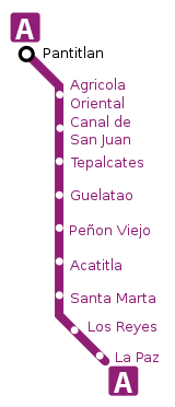
Line A was the second metro line that extended into the suburbs of Mexico City outside the Mexican Federal District. Opened in its entirety in 1991, it comprises ten stations over 17.192 km of track, of which 14.893 km are passenger track. Line A runs in a general south-east direction, east of the city center, and its color is purple.
Line A has only one underground station, the terminal Pantitlán, while the rest of the line runs at street-level. Only one station makes connections with other metro lines.
Line A is unique within the system in the sense that it uses traditional rail traction as opposed to pneumatic traction as the rest of the lines (excluding future line 12). As a reference, it is often called metro férreo. The line is served by FM-86 trains, built in Mexico in 1986 and FM-95A trains, also built in Mexico between 1998 and 1999, which draw electricity through a pantograph.

Line color purple Passenger railway length 14.893 km Total railway length 23.722 km Rolling stock FM86 trains, made in Mexico in 1986;
FM95A, made in Mexico in 1998 and 1999;
FE07, made in Spain in 2009Stations 10 Direction East-Far East Started operations August 12, 1991: From Pantitlán to La Paz Station Logo Date opened Station type Pantitlán Two flags August 12, 1991 Underground Agrícola Oriental Two ears of wheat Surface Canal de San Juan An Aztec canoe in a canal Tepalcates A mud plate Guelatao The head of Benito Juárez Peñón Viejo The Aztec representation of promontory Acatitla A sugarcane Santa Marta Santa Marta with a jar Los Reyes Three crowns La Paz A dove 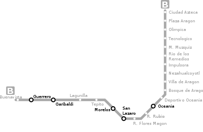
Line B became the third line to extend into the suburbs of Mexico City. The first section of the line was opened in 1999 and was expanded once to comprise a total of 21 stations over 23.722 km of track, of which 20.278 are passenger track. Line B starts north of the city center and runs in a general north-east direction relative to it. Its color is green on silver.
Six stations of line B run under ground, four are elevated and 11 run at street-level. Five stations connect with other metro lines.
All the trains are MP68 modified and equipped with GPS and intelligent control system, the trains in this line were the leftovers from Line 1 that were rehabilitated by Bombardier-Concarril.

Line color green over silver. Passenger railway length 20.278 km Total railway length 23.722 km Stations 21 Direction City Center-Far Northeast Started operations December 15, 1999: from Buenavista to Villa de Aragón
November 30, 2000: from Villa de Aragón to Ciudad AztecaStation Logo Date opened Station type Ciudad Azteca Aztec symbol of Tenochtitlan November 30, 2000 Surface Plaza Aragón A stand Olímpica The Olympic rings Ecatepec The Ecatepec symbol Múzquiz Melchor Muzquiz Río de los Remedios A ship with a crown Impulsora A cart Nezahualcóyotl The Nezahaulcoyotl symbol Villa de Aragón Some houses December 15, 1999 Bosque de Aragón Three trees Deportivo Oceanía A koala hugging a soccer ball Oceanía Kangaroo Elevated Romero Rubio Romero Rubio Ricardo Flores Magón Ricardo Flores Magón San Lázaro A locomotive Morelos José María Morelos Underground Tepito A boxing glove Lagunilla A swan Garibaldi A guitar and a sarape Guerrero Vicente Guerrero Buenavista The front of a Locomotive Line 12 (C); línea del Bicentenario: Mixcoac – Tláhuac
After a public consultation, on August 8, 2007; it was confirmed that this line will run from Mixcoac to Tláhuac, with 20 stations,[1] 4 of them linking with other lines, as well as with the Mexico City Metrobús.
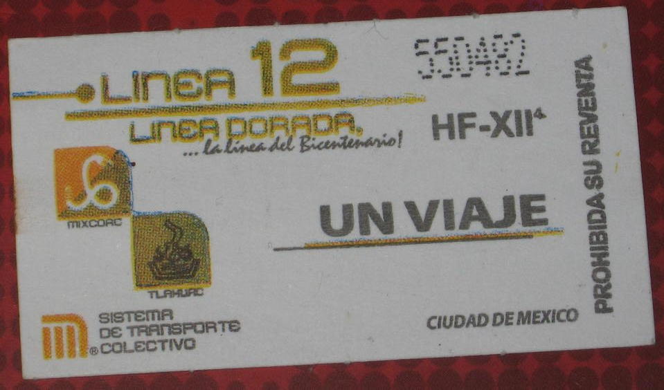
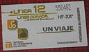 Ticket advertising new Line 12. Featuring Tlahuac and Mixcoac stations
According to the Mexico City Metro website, line 12 trains will use traditional rail traction (as line A).[2] This means it would be the second metro férreo, this could have been called line C but the reasons for numerical naming (which also implies lines A and B are 10 and 11 respectively) does not allow it, because the parameters of this series, imply that the lines numbered with letters instead of numbers are because those lines intersect areas of Mexico State (another entity of the country, adjacent to Mexico City). Government nicknamed it the línea del Bicentenario, commemorating the 200th anniversary of the beginning of Mexican War of Independence on September 16, 1810 and promising to deliver all twenty stations by April 30, 2012.
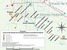 Map of Line 12
Line color Gold Passenger railway length 24 km Stations 20[1] Direction South-East Runs to Mixcoac to Tláhuac Opening 2010[citation needed] from Tlahuac Station to Axomulco Station[citation needed] Station Logo Date opened Station type[3] Notes Alta Tensión (?) ?? 2011 Underground
deepExpansion proposed to this avenue on Nov 15, 2008[4] Mixcoac A snake Insurgentes Sur / Félix Cuevas Miguel Hidalgo and Jose Maria Morelos 20 de Noviembre The structure of the cover of Medical Center 20 de Noviembre Zapata Emiliano Zapata Parque de los Venados The silhouette of two deers Eje Central A trolleybus Ermita A church Mexicaltzingo The Mexicaltzingo symbol Underground
shallowAtlalilco A water well Culhuacán A mountain with a curved top Elevated San Andres Tomatlan The San Andres Church Lomas Estrella A mountain system with a star on top Calle 11 A mountain with a fire symbol over a vase with water Periférico Oriente A vigilance tower Tezonco Candy skull traditional of the Day of the Dead Olivos An olive plant Nopalera A flower from nopal Zapotitlán A sapote tree Tlaltenco A stone arc Surface Tláhuac A seaweed from the region - Marked (?) appear on the Google Earth file given at the bottom of this page.
See also
- Servicio de Transportes Eléctricos
References
- ^ a b "Linea 12; Linea Dorado; la Linea del Bicentenario" (in Spanish). Mexico City Metro. p. b. http://www.metro.df.gob.mx/sabias/linea12b.html. Retrieved 14 August 2011.
- ^ "Linea 12; Linea Dorado; la Linea del Bicentenario" (in Spanish). Mexico City Metro. p. c. http://www.metro.df.gob.mx/sabias/linea12c.html#9. Retrieved 14 August 2011.
- ^ "Proyecto Metro GDF". http://www.proyectometro.df.gob.mx/proyecto. Retrieved 14 August 2011.
- ^ Cuenca, Alberto (14 November 2008). "Anuncia Ebrard ampliación de la Línea 12 del Metro: Se ampliará un kilómetro y medio más en su terminal poniente, por lo que ya no llegará a Mixcoac, sino hasta Alta Tensión" (in Spanish). El Universal. http://www.eluniversal.com.mx/notas/555664.html. Retrieved 14 August 2011.
- Government of the Mexican Federal District (2005). Metrobús-Proyecto. Last retrieved February 22, 2006.
- Monroy F., Marco A. (2004) [1] PDF map showing station type (Internet Archive link). Last retrieved February 25, 2006.
- Red de Transporte de Pasajeros del Distrito Federal (2005). Red de Rutas por Zona.-RTP. Last retrieved February 23, 2006.
- Servicio de Transportes Eléctricos del Distrito Federal (2003). Servicios.- Servicio de Transportes Eléctricos del D.F. Last retrieved February 22, 2006.
- Sistema de Transporte Colectivo (2005). Página del Sistema de Transporte Colectivo. Last retrieved February 22, 2006.
External links
- Map of the metro network in Google Earth - Google Earth is required to open this file.
- UrbanRail.Net page on the Mexico City Metro - Contains a general description of the system as well as a table showing the chronological order in which all sections of the system have been opened.
Categories:- Lists of metro stations
- Mexico City metro stations
- Mexico City Metro lines
- Mexico-related lists


Wikimedia Foundation. 2010.