- Metro Chapultepec
-
Chapultepec

Mexico City MetroJuanacatlán
Line 1
SevillaChapultepec is a station on the Mexico City Metro.[1][2] It is located in the Cuauhtémoc borough in the centre of Mexico City.[1]
The station logo depicts a grasshopper (chapulín).[1][2] The station's name comes from the Bosque de Chapultepec, a large nearby park that contains a hill with the same name.[1] Chapultepec means "grasshopper hill" in Nahuatl.[1] The station was opened on 5 September 1969 with service eastward to Sevilla, when Chapultepec served as the western terminus of Line 1.[3] Westward service from Chapultepec to Juanacatlán started 11 April 1970.[3]
Chapultepec lies along Line 1 only.[1][2] Despite no longer being a terminal and not being a transfer station for other metro lines, the station does play an important role as a bus transfer station, connecting with a vast array of microbuses that service the north of Mexico City and areas in the adjacent State of México, such as Ciudad Satélite, Valle Dorado, Arboledas and Cuautitlán Izcalli. It also connects with two trolleybus lines – one runs between Chapultepec and Metro El Rosario, and the other to the arterial thoroughfares known as Eje 2 Sur and Eje 2A Sur.
Chapultepec has an information desk; the station forecourt also contains a collection of retail stores, including a clothes boutique, a drugstore and a record store.
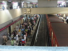 Track view inside the Chapultepec station
Reference
- ^ a b c d e f "Chapultepec" (in Spanish). http://www.metro.df.gob.mx/red/estacion.html?id=17. Retrieved 14 August 2011.
- ^ a b c Archambault, Richard. "Chapultepec » Mexico City Metro System". http://mexicometro.org/metro/line1/chapultepec/. Retrieved 14 August 2011.
- ^ a b Monroy, Marco. "Opening Dates for Mexico City's Subway". In Schwandl, Robert. http://www.urbanrail.net/am/mexi/mex-history.htm. Retrieved 14 August 2011.
External links
Line 1 of Mexico City Metro Stations Observatorio • Tacubaya • Juanacatlán • Chapultepec • Sevilla • Insurgentes • Cuauhtémoc • Balderas • Salto del Agua • Isabel la Católica • Pino Suárez • Merced • Candelaria • San Lázaro • Moctezuma • Balbuena • Boulevard Puerto Aéreo • Gómez Farías • Zaragoza • PantitlánTransfer Stations Coordinates: 19°25′15″N 99°10′35″W / 19.420783°N 99.176288°W
Categories:- Mexico City metro stations
- Railway stations opened in 1969
- Mexico metro stubs

Wikimedia Foundation. 2010.