- Chapultepec aqueduct
-
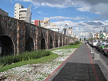 View of the arches of the aqueduct.
The Chapultepec aqueduct (in Spanish: el acueducto de Chapultepec) is an aqueduct originally built at Chapultepec by the Aztecs during the Tenochtitlan era;[1] its original name was simply the “Great Aqueduct.” What remains of the aqueduct today is located in Mexico City near Metro Sevilla.[2]
The project was started under the tlatoani Chimalpopoca and modified by Moctezuma I. It consisted of a twin-pipe construction made of compacted earth and wood;[citation needed] when one pipe needed maintenance, the water flowed through the other. Where it crossed Lake Texcoco, the aqueduct was raised above the water level to allow canoes to pass. While the Tenochtitlan rulers ordered the building of the aqueduct, it was Nezahualcoyotl from Texcoco who was the engineer, as he was for a number of other engineering feats in the Valley of Mexico.[1][3]
Colonial aqueduct
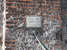 Plaque on aqueduct that reads, "Remains of the aqueduct begun in 1620 finished in 1790 containing 904 arches."
Shortly after the Spanish Conquest, Hernan Cortes set about dividing up land among the conquistadors. He wanted to take the forest of Chapultepec for himself, but Charles V denied him this and decreed that it and the springs needed to provide Mexico City with potable water would become property of the city itself.[4] Almost 100 years later, the Aztec aqueduct was replaced[4] under the reigning viceroy Fernando de Alencáster, Duke of Linares (1711-1716) and was known as the Chapultepec Aqueduct or the Aqueduct of Belen because of the old Belen convent it passed by.[citation needed] It was also to supply the city with fresh water from the springs in Chapultepec. The aqueduct passed through what is now Chapultepec Avenue and Arcos de Belen (Arches of Belen) Street, and was about four kilometers long with 904 arches. Only a small section, about twenty-two arches long, still survives today, on Chapultepec Avenue near Metro Sevilla.[2]
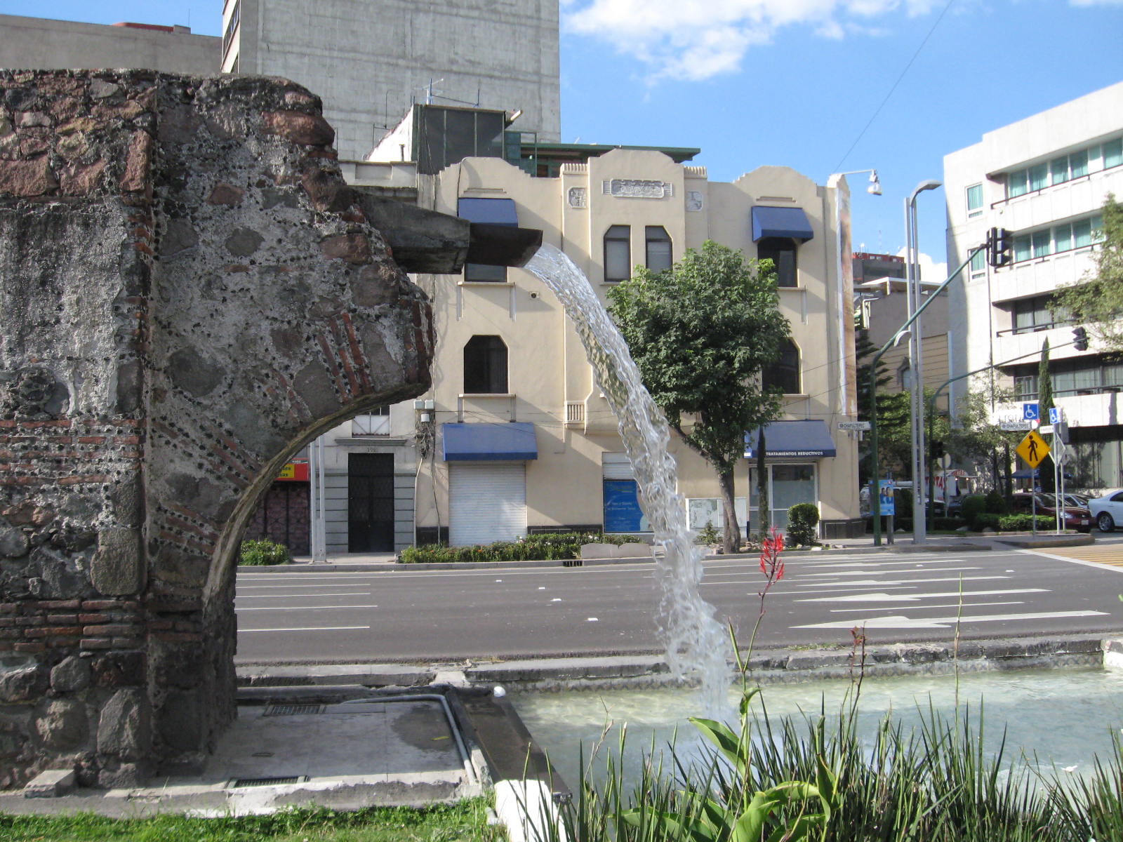
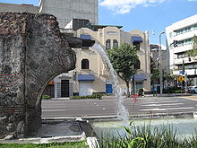 Fountain installed to imitate water flow through the aqueduct.
Also surviving are two fountains associated with the aqueduct. The first is found wedged between Chapultepec Park and Metro Chapultepec. Constructed by viceroy Marquis de las Armarillas, this fountain was designed to divert a portion of the water to this zone as well as be decorative. However, it is no longer in its original location: it was cleaned up, enlarged and moved to its current location by Roberto Alvarez Espinoza in 1921.[5] The other fountain is Salto del Agua which lies in its original location, at the intersection of Eje Central and Arcos de Belen Street, where the historic center meets Colonia Doctores and Colonia Obrera. While it is at the original location, it is not the original fountain. The original fountain had deteriorated badly, and a reproduction was made by Guillermo Ruiz. The remains of the original are on display at the Museo Nacional del Virreinato in Tepotzotlán.[5]
References
- ^ a b Raynal Villasenor, Jose A (April 1987). The remarkable hydrological works of the Aztec civilization. Water for the Future:Hydrology in Perspective Proceedings of Rome Symposium IAHS.
- ^ a b Humphrey, Chris (2008). Moon Mexico City. Avalon Travel. ISBN 1598800833, 9781598800838. http://books.google.com/?id=caSI8cPgB88C&pg=PA52&lpg=PA52&dq=Avenida+Chapultepec+aqueduct. Retrieved 2008-11-15. "Page 52: ...22 of its 904 arches still stand, looking a bit forlorn, along Avenida Chapultepec, near the Sevilla Metro station.)"
- ^ Herzog, Lawrence Arthur (2006). Return to the Center: Culture, Public Space, and City Building in a Global Era. University of Texas Press. ISBN 0292712626, 9780292712621. http://books.google.com/?id=VyjL_E2q6UoC&pg=PA119&lpg=PA119&dq=Chapultepec+Aqueduct. Retrieved 2008-11-15. "Page 119: After a terrible flood in 1449, the leader Nezahualcoyotl set up an improved wall and dyke system and built the main Chapultepec aqueduct..."
- ^ a b "Chapultepec". http://www.elclima.com.mx/chapultepec.htm. Retrieved 2008-11-18.
- ^ a b Prado Nuñez, Ricardo (1965) (in Spanish). Catalogo de Monumentos Escultoricos y Conmemorativos del Distrito Federal. pp. 20–23.
Categories:- Aqueducts in Mexico
- Landmarks in Mexico City
- Buildings and structures in Mexico City
- Buildings and structures in Mesoamerica
- Aztec sites
- Aztec science and technology
- Tenochtitlan


Wikimedia Foundation. 2010.