- Colonia Doctores
-
Colonia Doctores is an official neighborhood just southwest of the historic center of Mexico City. It is bordered by Avenida Cuauhtémoc to the west, Arcos de Belen Street to the north, Eje Central to the east and Eje 3 Sur José Peón Contreras to the south.[1]
Contents
History
The neighborhood was planned by Francisco Lascuráin in 1889, in an area called "La Indianilla".[2] This name came from three indigenous women named María Clara, María Concepción and María Paula sold some of their land here to Father Domingo Pérez Barcia to build a small chapel. However, Lascuràin never followed through with his plans to construct the neighborhood. In 1895, The Mexican City Propiety Sindicate Limited proposed the plan to lay out the neighborhood anew, gaining approval of the Mexico City ayuntamiento. The major streets such as Niños Heroes, Dr. Lavista, and Dr. Río de la Loza were laid out.[1]
Originally the colonia was called "Hidalgo" but, as almost all of the streets here are named after famous physicians, the area became known as "Doctores," leading to its current official name.[2]
 Temple of "Nuestra Señora de Belén" (Our Lady of Bethlehem) located on Arco de Belen street.
In 1880, Ramón Guzmán, owner of an enterprise of streetcars pulled by mules, established a yard here for the maintenance and storage of his vehicles. Today the Procuraduría de Justicia del D.F. (Court house of the Federal District) is located in its place. A couple of decades later, a large part of this area was owned by the Compañía de Tranvías, also known as the Mexican Electric Transway, serving as a trainyard as well as housing workshops for the maintenance and repair of rail cars. This service began in 1900.[1] Train engineers, who worked all hours, gave rise to vendors selling food, especially chicken soup ("caldo de pollo") in the late night and early morning hours. This tradition remains and the area is noted for its soup.[2]
Sites of interest
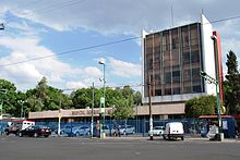 Hospital General de México, located on Dr. Balmis street near Avenida Cuauhtémoc and Metro station Hospital General.
General Hospital of Mexico
The Hospital General de Mexico was inaugurated on 5 February 1905 and covers seventeen hectares.[2] Today, the hospital employs 6,000 professionals including doctors, nurses, technicians, paramedics and administrators. Each day, the hospital treats 3,000 outpatients, discharges about 112 inpatients, and performs 164 surgeries and other invasive procedures. It has 39 medical specialties in treatment, diagnostics and rehabilitation, providing care at the secondary and terciary level. The hospital also receives each year 1,163 medical students and 447 residents as well as 1,624 nursing students and other paramedical trainees. It is also a research hospital with 70 investigators, 27% of whom are members of Mexico's National System of Researchers (SNI), publishing about 158 articles each year.[3]
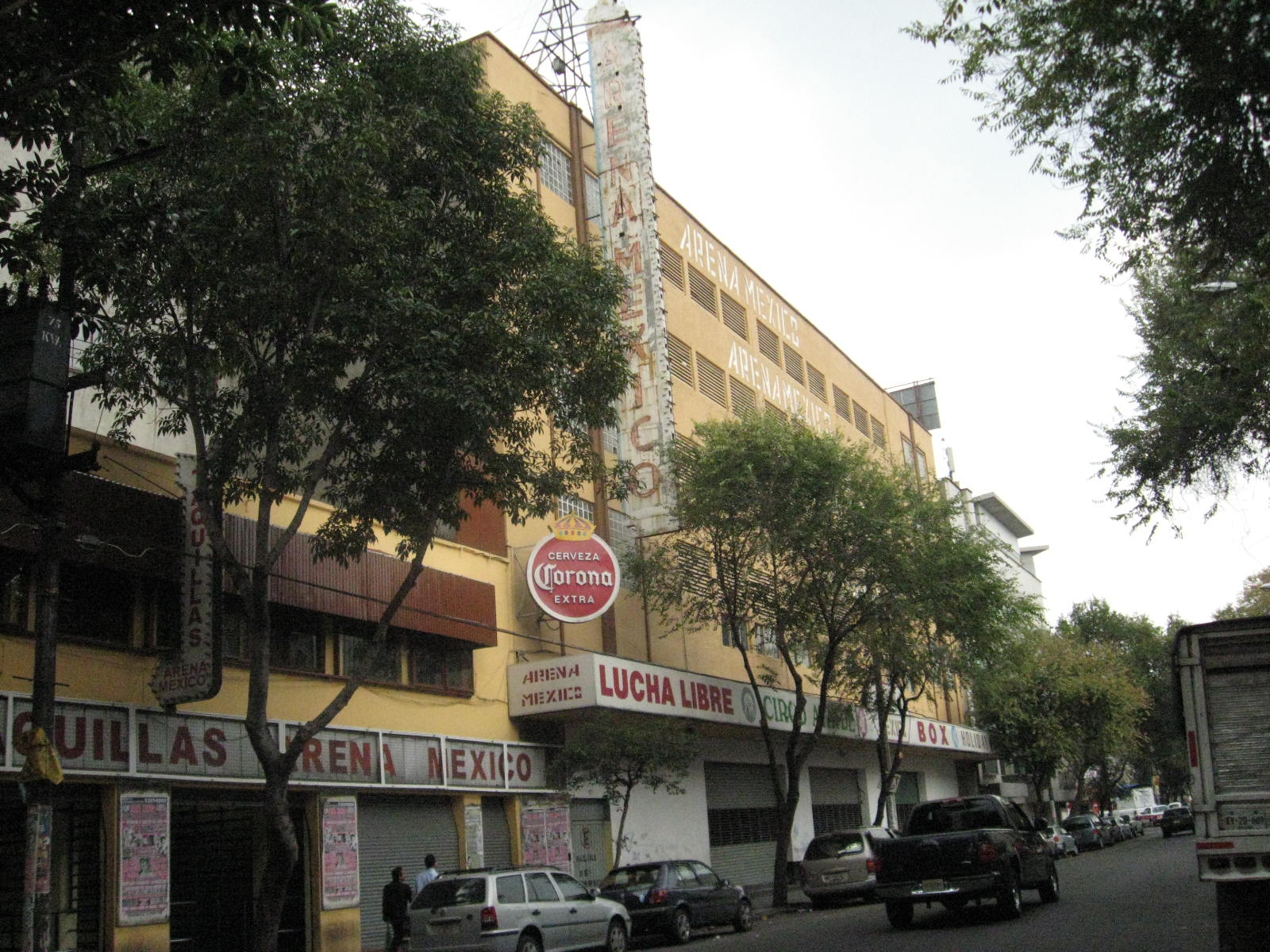
Arena México
 Arena México on Dr. Lavista Street.Main article: Arena México
Doctores is home of "Arena México," one of the more important staging places of Mexican lucha libre or professional wrestling, located on Dr. Lavista. Every Tuesday and Friday night, fights are staged between "good" wrestlers and "bad" wrestlers who often represent the trials and tribulations of the country.[4] It is the self proclaimed "cathedral" of Mexican lucha libre, sporting not only top names but those just beginning their wrestling careers.[5]
Ex-Belén Prison
It was home to the old Belén Prison, which today is the Instituto Maria Isabel Dunde preschool and primary school that houses murals by Raúl Anguiano and glasswork by Revueltas.[2]
-

Belén prison as viewed from Dr. Vértiz and Dr. Velasco streets.
-

Front view of Belén from Dr. Velasco and Dr. Jiménez streets.
Escuela Libre de Derecho (Free School of Law)
 View of the Escuela Libre de Derecho from Dr. Río de la Loza Street.
Located on Dr. Vértiz 12, on the corner of Arcos de Belén, it is one of the most prestigious law schools in Mexico, and second only to UNAM in age. It was founded 14 July 1912, during a time when Mexico was in political turmoil, including student unrest against the regime of President Porfirio Díaz. It offers degrees at both the bachelor's and master's levels for those seeking careers as lawyers and other aspects of juridical science.[6]
 Porfirio Díaz mansion.
Porfirio Díaz mansion
On Doctor Jiménez street, is an old mansion that was a wedding gift for Porfirio Díaz and his new wife doña Carmen Romero Rubio. They first used the house as a getaway as this area was just on the outskirts of the city at the time. In 1904, they decided to convert it into an educational center for working mothers and their children, known as the "Casa Amiga de la Obrera" (Friends House of the Working Woman).[2] It is now the Escuela de Participación Social No. 1 (Social Participation School No. 1) primary school affiliated with UNESCO.
 Centro Cultural Estación Indianilla.
Centro Cultural Estaciòn Indianilla
The Centro Cultural Estación Indianilla is located on Claudio Bernard Street in the colonia. This cultural center was opened in 2006 in what was an old workshop for the reparation of tram cars. The building had been in disrepair for a number of decades. It now houses exhibition space for modern and "alternative" art, taking advantage of the buildings tall ceilings and rooms built to accommodate railcars. In its basement, is the Frida de Juguete Arte Objeto Museum with pieces from artists such as Alberto Castro Leñero, Ángel Fermín Vizuet, Francisco Toledo, Gustavo Pérez, Irma Palacios, Jazz Moart and Joe Laville.[7]
Centro Médico Siglo XXI (IMSS) (21st Century Medical Center-IMSS)
This facility was inaugurated in 1964, becoming the most important center for specialized medicine in the country. It is located on Cuauhtémoc Avenue in the far southwest corner of the colonia. The hospital houses about 30 works of art from fourteen different artists such as David Alfaro Siqueiros, Federico Cantú, Luis Nishizawa, Francisco Zúñiga, José Chávez Morado, Salvador Pinoncelly and Tosia Malamud. The 1985 Mexico City earthquake damaged many of the buildings's foundations requiring demolitions but their artworks were salvaged. The center sees the art as an integral part of the healing process. Inside the main entrance of the hospital is a mural called "Homage to rescue" by José Chávez Morado. It is 230 square meters etched in marble done between 1988 and 1999.[8]
Government buildings
This area, especially the northern section, is home to a number of Mexico City's governmental offices, including:
- Procuraduría General de Justicia del Distrito Federal, on Gabriel Hernández Street.
- Asesoría Jurídica Laboral, on Dr. Lucio St.
- Comisión de Derechos Humanos del Distrito Federal, on Doctor Río de la Loza St.
- Instituto Electoral del Distrito Federal, on Orozco y Berra St.
- Fondo de Seguridad Pública del D.F., on Gabriel Hernández St.
- Fondo para la Atención y Apoyo a las Victimas del Delito, on Gabriel Hernández St.
- Instituto de Formación Profesional del D.F., on Gabriel Hernández St.
- Sistema de Corredores de Transporte Público de Pasajeros del Distrito Federal (Metrobús), on Av. Cuauhtémoc.
Reputation
The area has a reputation of being high crime. It was ranked in the top 25 neighborhoods of the city for percentage of residents incarcerated.[9] and it was ranked fourth in the top ten most “dangerous” neighborhoods, based on number of reported crimes per capita, behind Centro, Colonia del Valle, and Colonia Narvarte.[10] It is also known for its large numbers of cantinas, cabarets and “hotels de paso”(hotels with hourly rates).[9] However, most of the crime associated with this area is related to car theft and chop shops. For example, a Hummer stolen from El Paso, Texas, was recently found intact on the streets here.[11]
Colonia Doctores used to be the home to many “pulquerías”, bars or cantinas that serve pulque to a mostly lower-class clientle. However, in Mexico City, these establishments have been heavily regulated because they were often seen as centers of vice. Due to this, and the increasing popularity of beer, very few pulquerías, such as "La Hija de los Apaches," on Dr. Lavista 186, still exist.[12]
References
- ^ a b c "Colonia Doctores" (in Spanish). http://www.cuauhtemoc.df.gob.mx/delegacion/mapa/colonias.html. Retrieved 2008-10-24.
- ^ a b c d e f Merida, Bernardino (2005-05-22). "La colonia Doctores, joven a sus 116 años". El Universal.
- ^ "Mensaje de Bienvenida" (in Spanish). http://www.hospitalgeneral.salud.gob.mx/interior/mensaje.html. Retrieved 2008-10-05.
- ^ "Heroes en la Doctores". http://www.mx-df.net/?p=30#more-30. Retrieved 2008-09-02.
- ^ "¿Lucha Estrella? ¡Bring on the Kids!". http://www.arenamexico.com.mx/texto.aspx?id_contenido=106. Retrieved 2008-10-05.
- ^ "Escuela Libre de Derecho-Historia" (in Spanish). http://www.eld.edu.mx/. Retrieved 2008-10-05.
- ^ "Centro Cultural Estacion Indianilla". http://www.ciudadmexico.com.mx/atractivos/estacion_indianilla.htm. Retrieved 2008-09-10.
- ^ "EL CENTRO MÉDICO NACIONAL SIGLO XXI, UN ESPACIO VITAL PARA LAS ARTES, LA CULTURA Y LA SALUD" (in Spanish) (Press release). IMSS Coordinacion de Comunicacion Social. 2008-04-19. http://www.imss.gob.mx/NR/rdonlyres/7DD16061-4698-4E3D-8ED4-BCC49A737BA1/0/190408Com145.doc. Retrieved 2008-10-13.
- ^ a b Gonzalez Alvarado, Rocio (05-06-2007). "La Doctores, una de las 25 colonias de la ciudad con más personas en reclusorios". La Jornada. http://www.jornada.unam.mx/2007/06/05/index.php?section=capital&article=041n1cap. Retrieved 2008-09-03.
- ^ "Ubican a las 10 colonias mas peligrosas del DF". La Terra. 04-05-2008. http://www.terra.com.mx/articulo.aspx?articuloId=655535. Retrieved 2008-09-03.
- ^ "Recuperan Hummer texana en la colonia Doctores". Ex Online. 2008-07-23. http://www.exonline.com.mx/diario/noticia/comunidad/pulsocapitalino/recuperan_hummer_texana_en_la_colonia_doctores/293725. Retrieved 2008-09-03.[dead link]
- ^ Aviña, Jose Carlos (03-08-2008). "Desaparece la tradicion pulquera en el DF". El Sol. http://www.oem.com.mx/elsoldemexico/notas/n797833.htm. Retrieved 2008-09-03.
External links
- [1] www.mx-df.net
19°25′3.38″N 99°8′50.74″W / 19.4176056°N 99.1474278°WCoordinates: 19°25′3.38″N 99°8′50.74″W / 19.4176056°N 99.1474278°W
Colonias and Neighborhoods of Cuauhtémoc, D.F. Colonias Colonia Centro • Colonia Doctores • Colonia Obrera • Colonia Roma • Tepito • Colonia Algarín • Colonia Ampliación Asturias • Colonia Asturias • Colonia Atlampa • Colonia Buenavista • Colonia Buenos Aires • Centro Urbano Benito Juárez • Colonia Condesa • Colonia Cuauhtémoc • Colonia Esperanza • Colonia Exhipódromo de Peralvillo • Colonia Felipe Pescador • Colonia Guerrero • Colonia Hipódromo • Colonia Hipódromo Condesa • Colonia Juárez • Colonia Maza • Colonia Morelos • Colonia Paulino Navarro • Colonia Peralvillo • Colonia San Rafael • Colonia San Simón Tolnahuac • Colonia Santa María Insurgentes • Colonia Santa María la Ribera • Unidad Habitacional Nonoalco-Tlatelolco • Colonia Tabacalera • Colonia Tránsito • Colonia Valle Gómez • Colonia Vista Alegra • Zona Rosa
Categories:- Neighborhoods in Mexico City
-


Wikimedia Foundation. 2010.