- Colonia del Valle
-
This article is about the Mexican neighborhood. For the Argentinian neighborhood, see Colonia del Valle, Catamarca.
Colonia del Valle Buildings of del Valle neighborhood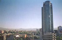 Del Valle neighborhood is located in the Benito Juarez borough.
(Map showing location of the borough within Mexico City)Colonia del Valle (Spanish for: Del Valle neighborhood) is a neighborhood in the Benito Juarez borough of Mexico City.[1] The city includes "...a great number of parks, vast and tree-lined streets, prestigious shopping malls, and some city landmarks...".[2] Del Valle neighborhood is bounded by the streets of Viaducto Miguel Alemán to the north, Cuauhtémoc and Universidad to the east, Rio Mixcoac - Barranca del Muerto to the south and Insurgentes Avenue to the west.
Adjacent neighborhoods include Nápoles, Ciudad de los Deportes, Nochebuena and San Borja to the west, Escandón to the northwest, Roma Sur and Piedad Narvarte to the north, Narvarte, Vértiz Narvarte and Letrán Valle to the east, and Tlacomecatl del Valle, Miguel Alemán, Xoco and Santa Cruz Atoyac to the south.[3]
Contents
Origin and development
The beginning of the 20th century initiated the division of the ranches cultivated with alfalfa and fruit trees, giving rise to the area, named as Colonia Americana (English: American neighborhood). These farms were the most popular and loved, Tlacoquemécatl (where the Chapel of the Good Lord Firm and its park are located), Santa Anita and San Borja. Some neighborhood streets are named after these ranchos and their fruit trees, others after Mexican philanthropists.
While serving as a streetcar route from Mexico City to Coyoacán it developed slowly until 1920, when it expanded and the Avenida de los Insurgentes was paved. Large-scale home and mansion construction started. That marked the development of the area, to which was added monument construction and green areas; one is the Paque Hundido, built on a former sand mine.
In the 1960s the area was as fully developed as many other neighborhoods of equal purchasing power on its borders. Commercial development was inevitable. This included two major events, the opening of Liverpool Insurgentes in 1962 and the first shopping center in the country, University Plaza, in 1969.
In 1978 the decision to build the road axes transformed the neighborhood radically and permanently, from quiet streets to a river of asphalt, axes 4, 5, 6, 7 and 8 south crossing from east to west and 1, 2 and 3 do west from south to north. This resulted in many families looking for quieter places to live and began the inexorable process of redeveloping the land. Mansions were replaced by apartment buildings, offices or schools.
Architecture
The architectural style developed in the area includes large mansions in Californian mission revival Art Deco style and, to a lesser extent, surviving examples of Porfiriato. At the end of the 1960s many small skyscrapers, both commercial and residential, were built, making the area one of the most densely populated of Mexico City. Housing complexes were also built.[citation needed]
Currently the diversity of architectural styles and the population are still developing, but there is a wish to recover household spaces and family activities.[citation needed]
The neighborhood architectural styles range from colonial to contemporary. It houses churches such as the Temple of the Immaculate Heart of Mary, and buildings dating from the period of colonization and conquest between park Tlacoquemécatl including the Temple of San Lorenzo and the Xochimanca, cultural areas and parks like the Sunken Park or Mariscal Sucre Park, the French Kiosk, art galleries, libraries, auditoriums Polyforum Cultural Siqueiros, Plaza México, and Estadio Azul stadium.
Religious buildings
The religious structures found in the Del Valle include the Parish of the Most Pure Heart of Mary at the corner of Gabriel Mancera number 415. It was built in the early 20th century. In 1996 several scenes of the film Romeo + Juliet were filmed at the church. Mexican singer Luis Miguel was baptized there.[citation needed]
The Good Lord Parish Office, located in Tlacoquemécatl park, dates from the 16th century. Temple Santo Tomás Actipan, built in 1897, is located at the confluence of the streets of Buffalo and Tiger. The Temple of San Lorenzo Xochimanca, located in the park of the same name, was built in the 16th century. The Temple of Santa Monica, located at No. 126 Strawberry Street opposite the park of San Lorenzo, was built in 1962. The Parish of Divine Providence in Adolfo Prieto street was constructed between 1968 and 1974.[citation needed]
Tourism & Shopping
Del Valle is a landmark neighborhood within the city and a tourism center.[citation needed]
Plaza Universidad shopping mall is located in the neighborhood as is the World Trade Center Mexico.[citation needed]
Education
Within the Del Valle are two of the oldest educational institutions in the country; the College and Institute of Mexico and its Centro Universitario Mexico, and the Colegio Simón Bolívar. Graduates of these schools include Octavio Paz and Germán Dehesa.[citation needed]
Trasportation
Major roads running through the neighborhood include: Insurgentes, Cuauhtemoc, Northern Division, University, Félix Cuevas, José María Rico, Xola.[citation needed] Subway line 3 has several stations in the vicinity: Ethiopia, Eugenia, Northern Division, Zapata and Coyoacan.[citation needed]
References
- ^ "Mapa de la delegación Benito Juárez y la colonia Del Valle" (in Spanish). El Universal. 20. http://www.eluniversaldelvalle.mx/detalle1941.html. Retrieved 5 August 2011.
- ^ "Colonia del Valle" (in Spanish). ciudaddemexico.com.mx. http://www.ciudadmexico.com.mx/zonas/colonia_del_valle.htm. Retrieved 4 August 2011. "...es conocida por su gran cantidad de parques, sus amplias y arboladas calles, sus prestigiosos centros comerciales y algunos símbolos de la ciudad..."
- ^ "Ubicacion" (in Spanish). Guía Roji. http://mapas.guiaroji.com.mx/ubicacion.php?gv_mapa=1&gv_calle=&gv_colonia=DEL+VALLE&gv_delegacion=BENITO+JUAREZ&gv_cp=3100&gv_x=483004.105660482&gv_y=2143723.80057048. Retrieved 5 August 2011.
External links
- Colonia del Valle on the Internet (Spanish)
Coordinates: 19°23′21″N 99°10′04″W / 19.389164°N 99.167668°W
Categories:- Neighborhoods in Mexico City

Wikimedia Foundation. 2010.