- Colonia Obrera
-
Colonia Obrera is an administrative neighborhood of the borough of Cuauhtémoc in the center of Mexico City. It was established in the late 19th and early 20th centuries and became home to many artisans and industrial workmen. Up to the early 1980s, a number of sewing factories were still located here, but the 1985 Mexico City earthquake destroyed many, including the Topeka factory in which many of the seamstresses died inside. Today, the area has a high crime rate but there have been efforts to revitalize it.
Contents
Location
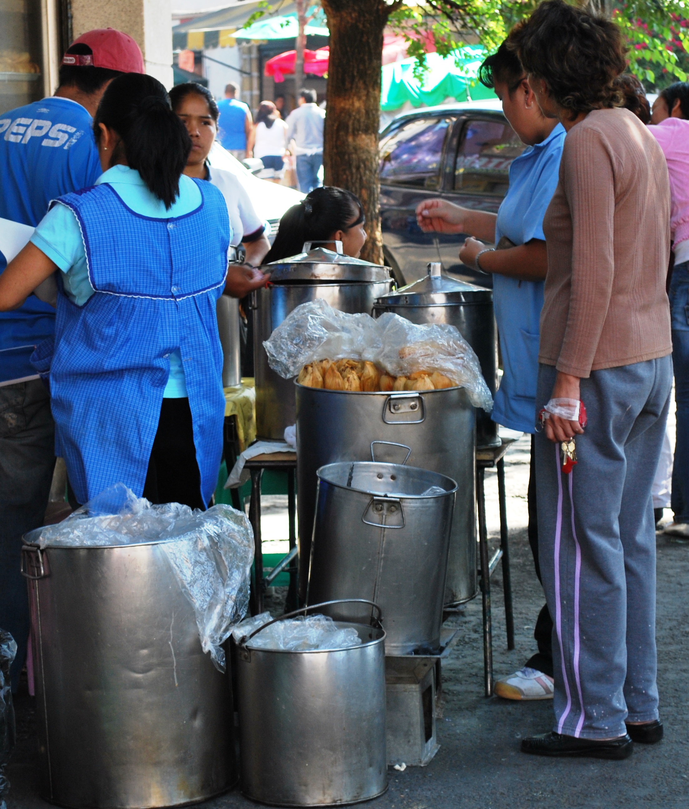
 Buying and selling tamales in the neighborhood
The neighborhood is bounded by Chimalpopoca Street to the north, Eje Central to the west, San Antonio Abad to the east and Eje Tres Contreras to the south. In addition to the streets that define its borders, other major streets include the elongations of 5 de Febrero, Isabel la Catolica and Bolivar south from the historic center. Major east-west roads include Boturini, Manuel J.Othon, Manuel Payno and Jose Maria Roa Barcenas.[1]
History
The project to create the neighborhood was announced in 1889, with the original name of El Cuartelito. It was laid out and lots were sold before official authorization or municipal services were established.[1] Many of the lots created here were acquired by artisans.[2] Efforts to make the lands legal and to install municipal services began around the same time. By 1920, the colonia had taken on its modern form and a canal which used to drain the area was dried out and covered over to make José T. Cuellar Street. Around this time was built the Santiago Galas building, which was the station for the FF.CC. Mexico Tlalpan rail line for many years.[1]
In the first decades of the 20th century, it was one of the most important neighborhoods as industrialization took hold in the city. During this time period, many artisans, semi-skilled and skilled labor were organizing into unions. In this neighborhood brothers Ricardo and Enrique Flores Magón organized the Partido Liberal Mexicano. They also published a newspaper called Regeneración beginning in 1900.[2]
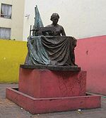 Bronze statue at corner of Manuel J Othón and San Antonio Abad at site of collapsed factory
Up until the 1980s, the northeast of this neighborhood had a number of sewing factories, especially near station San Antonio Abad. During the 1985 Mexico City earthquake, a number of these were destroyed. One in particular, called “Topeka” was located on Manuel José Othón Street and was the scene of many deaths.[3][4] The magazine Proceso reports that by the time rescue workers got to the building, the owners were already in a hurry to demolish it, without trying to rescue or recover the seamstresses that were trapped inside.[5] About 150 bodies of workers had already been pulled from the wreckage by other workers with their bare hands.[4] The collapse of this factory exposed the deplorable conditions that many of these seamstresses were subject to. The building that collapsed, as well as many others, were found to be decrepit. It came to be known that many of these women had to work extended hours with little or no compensation, and few, if any of the labor laws on the books were being followed. This event made the garment industry of the area a labor embarrassment.[6] All that is left to remind of the factory is a small empty lot with a bronze statue of a woman sewing to commemorate the event.[4] On the rest of the property, apartments have been built.[4]
Crime and efforts to renew the area
The colonia is located in the borough of Cuauhtémoc, which has some of the highest crime rates in the city the same as Tepito, one of the notorious places for being unsafe. Obrera is listed in the top ten as far as crimes reported, which include small scale drug trafficking and indigence.[7] Young architects from Mexico City, participating in the XI International Architecture Show in Italy, proposed a project for this area based on the philosophy of recycling of urban land. Their project was sponsored by the Consejo Nacional para la Cultura y las Artes and the Instituto Nacional de Bellas Artes. The goal of this project was to convert older industrial and warehouse space into 5,000 new living quarters, centered on Ixtapaluca Street.[8] Very soccer: For a long time (up to 2000) was known for being a football soccer fan neighborhood, on every street (Barcenas, 5 de Febrero, 20 Noviembre, etc.) Was safe to watch a soccer match on Sunday, better known as "Las Retas", where they met about 8 and 20 young children and adults to participate for a moment and feel great players.
References
- ^ a b c "Colonia Obrera" (in Spanish). Mexico City: Cuauhtémoc, D.F.. http://www.cuauhtemoc.df.gob.mx/delegacion/mapa/colonias.html. Retrieved July 11, 2010.
- ^ a b "Obrera" (in Spanish). Mexico City: Mexico City Metro Authority. http://www.metro.df.gob.mx/red/estacion.html?id=104. Retrieved July 11, 2010.
- ^ (in Spanish). Mexico City. 1987. pp. 8–28.
- ^ a b c d Notimex (2005-09-19). "Misa en honor de costureras muertas en 1985" (in Spanish). http://www.esmas.com/noticierostelevisa/mexico/475900.html. Retrieved 2008-10-09.
- ^ Ponce, Roberto. "Los buenos los malos y las feas cifras y realidades del terremoto segun un libro de un brigadista de Plácido Domingo url=http://www.proceso.com.mx/impreso_articulo.php?articulo=130785" (in Spanish). Mexico City: Proceso.
- ^ Flores, Miguel Angel. "Zona de Desastre" (in Spanish). Proceso. http://www.proceso.com.mx/impreso_articulo.php?articulo=92538. Retrieved 2008-10-11.[dead link]
- ^ Servin Vega, Mirna (July 28, 2007). "En la delegación Cuauhtémoc, siete de las 10 colonias más conflictivas del DF [In the Cuauhtemoc borough, seven of ten of the most conflictive colonias in the Distrito Federal]" (in Spanish). La Jornada (Mexico City: UNAM). http://www.jornada.unam.mx/2007/07/28/index.php?section=capital&article=035n1cap. Retrieved July 11, 2010.
- ^ CONACULTA. "Buscan en la colonia obrera alternativas de vivienda económica [Looking for alternative affordable housing in Colonia Obrera]" (in Spanish). Artes e Historia. Mexico. http://www.arts-history.mx/banco/index.php?id_nota=10092008162526. Retrieved July 11, 2010.
Colonias and Neighborhoods of Cuauhtémoc, D.F. Colonias Colonia Centro • Colonia Doctores • Colonia Obrera • Colonia Roma • Tepito • Colonia Algarín • Colonia Ampliación Asturias • Colonia Asturias • Colonia Atlampa • Colonia Buenavista • Colonia Buenos Aires • Centro Urbano Benito Juárez • Colonia Condesa • Colonia Cuauhtémoc • Colonia Esperanza • Colonia Exhipódromo de Peralvillo • Colonia Felipe Pescador • Colonia Guerrero • Colonia Hipódromo • Colonia Hipódromo Condesa • Colonia Juárez • Colonia Maza • Colonia Morelos • Colonia Paulino Navarro • Colonia Peralvillo • Colonia San Rafael • Colonia San Simón Tolnahuac • Colonia Santa María Insurgentes • Colonia Santa María la Ribera • Unidad Habitacional Nonoalco-Tlatelolco • Colonia Tabacalera • Colonia Tránsito • Colonia Valle Gómez • Colonia Vista Alegra • Zona Rosa
19°24′49.61″N 99°8′19.45″W / 19.4137806°N 99.1387361°WCoordinates: 19°24′49.61″N 99°8′19.45″W / 19.4137806°N 99.1387361°W
Categories:- Neighborhoods in Mexico City

Wikimedia Foundation. 2010.