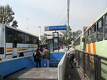
- Metro Cuatro Caminos
-
Metro Cuatro Caminos (translated from Spanish the name literally means "Four Roads") is a station of the Mexico City metro network.[1][2] It is the current north terminus of Line 2 and serves as a hub for regional transport from and into the State of México.[1][3]
As of 14 September 1970 Line 2 originally terminated at Metro Tacuba, but on 22 August 1984 the line was extended an additional two stations to reach the municipality of Naucalpan.[3] The station sits on the dividing line between the Federal District and the neighboring state of México and as such was the first station of the network to be built outside the limits of the Federal District.
The station logo is a large geodesic dome depicting the former nearby Toreo de Cuatro Caminos bull fighting ring, which the station takes its name from,[1] however the bullring was torn down in 2008.[4] The station's surroundings (popularly known as the paradero), are the main public transport hub to Toluca and northwestern municipalities in the State of Mexico, such as Naucalpan, Atizapán, Tlalnepantla or Huixquilucan, as well as a major connection point to several destinations within the Mexico City proper and it also serves as the housing of a large street market, which is known largely because of its poor general conditions.[5] Officially, no private vehicles are allowed in the area.
Upon leaving the station, there are two main corridors, labeled "North" and "South". North corridor (denoted by the exits A to K), is mainly used for transportation to State of Mexico, while the "South" corridor is mainly aimed at passengers going to the city (denoted by exit letters J to Z), though this is not strictly the case.
The South corridor (if walked) leads to the Periférico, the Pericentro shopping mall and many military facilities, while the North corridor leads to the industry complex of Naucalpan.
In 2003, the Mexican popular music group Café Tacuba produced an album with the title "Cuatro Caminos" in homage to this part of the city.[6]
See also
References
- ^ a b c "Cuatro Caminos" (in Spanish). http://www.metro.df.gob.mx/red/estacion.html?id=21. Retrieved 16 August 2011.
- ^ Archambault, Richard. "Cuatro Caminos » Mexico City Metro System". http://mexicometro.org/metro/line2/cuatro-caminos/. Retrieved 16 August 2011.
- ^ a b Monroy, Marco. "Opening Dates for Mexico City's Subway". In Schwandl, Robert. http://www.urbanrail.net/am/mexi/mex-history.htm. Retrieved 15 August 2011.
- ^ Chávez, Silvia (6 September 2008). "Inicia demolición del Toreo de Cuatro Caminos". La Jornada. http://www.jornada.unam.mx/2008/09/06/index.php?section=estados&article=030n2est. Retrieved 19 August 2011.
- ^ "Califican de ‘bomba de tiempo’ al paradero de Cuatro Caminos". http://www.eluniversal.com.mx/ciudad/86312.html. Retrieved October 18, 2010.
- ^ Jurek, Thom. "Cuatro Caminos - Café Tacuba". AllMusic. http://www.allmusic.com/album/cuatro-caminos-r647027/review. Retrieved 19 August 2011.
External links
Preceding station Mexico City Metro Following station — Línea 2 Panteones Transfer Stations Coordinates: 19°27′35″N 99°12′57″W / 19.459592°N 99.215899°W
Categories:- Mexico City metro stations
- Railway stations opened in 1984
- Mexico metro stubs
Wikimedia Foundation. 2010.


