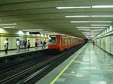
- Metro Zapata
-
Metro Zapata is a station on the Mexico City Metro.[1][2] The station logo depicts Emiliano Zapata, a national hero from the Mexican Revolution of 1910–1921.[1][2] This station used to be the terminus of Line 3; while the line has since been extended south, it still plays an important role in the transportation of the city's inhabitants.[3] The metro station was opened on 25 August 1980.[3] Above the station is a microbus base, recently built and a few blocks away is an important commercial area for the city, with malls, grocery stores, price clubs, cinemas and restaurants.
Metro Zapata also transfers to trolleybus Line "D", which runs between Metro Mixcoac (Line 7) and the San Andrés Tetepilco neighbourhood.[4]
The station serves the Del Valle and Santa Cruz Atoyac neighborhoods at the intersection of Universidad, Zapata, Municipio Libre, Felix Cuevas and Heriberto Frias.[1]
References
- ^ a b c "Zapata" (in Spanish). Sistema de Transporte Colectivo. http://www.metro.df.gob.mx/red/estacion.html?id=57. Retrieved 14 August 2011.
- ^ a b Archambault, Richard. "Zapata » Mexico City Metro System". http://mexicometro.org/metro/line3/zapata/. Retrieved 14 August 2011.
- ^ a b Monroy, Marco. "Opening Dates for Mexico City's Subway". In Schwandl, Robert. http://www.urbanrail.net/am/mexi/mex-history.htm. Retrieved 14 August 2011.
- ^ "Servicios.- Servicio de Transportes Eléctricos del D.F.: Línea: D LINEA D EJE 7 - 7 A SUR Fuera de Servicio" (in Spanish). Servicio de Transportes Eléctricos. http://www.ste.df.gob.mx/servicios/consultaLinea.html?id_trolebus=D. Retrieved 20 August 2011.
External links
Preceding station Mexico City Metro Following station División del Norte Línea 3 Coyoacán 20 de Noviembre Línea 12 Parque de los Venados Transfer Stations Line 12 of Mexico City Metro (under construction) Stations Transfer Stations Coordinates: 19°22′15″N 99°09′54″W / 19.370952°N 99.164937°W
Categories:- Mexico City metro stations
- Railway stations opened in 1980
Wikimedia Foundation. 2010.

