- Marsh Concrete Rainbow Arch Bridge
-
Marsh Concrete Rainbow Arch Bridge


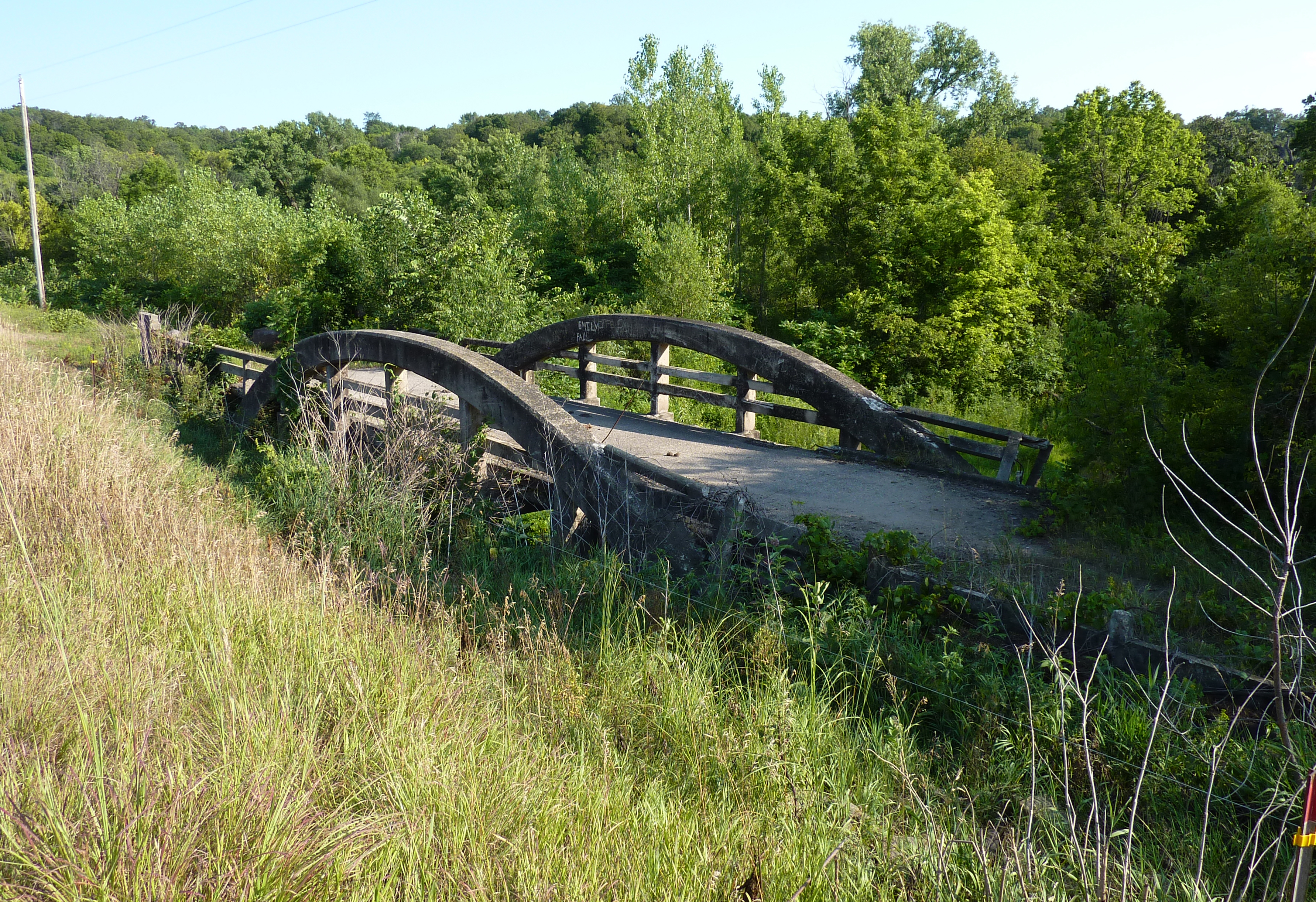
Nearest city: Courtland, Minnesota Coordinates: 44°14′13″N 94°21′39″W / 44.23694°N 94.36083°WCoordinates: 44°14′13″N 94°21′39″W / 44.23694°N 94.36083°W Area: less than one acre Built: 1911 Architect: Marsh Engineering Co. Architectural style: Concrete rainbow arch bridge Governing body: Local MPS: Blue Earth County MRA NRHP Reference#: 80001953[1] Added to NRHP: July 28, 1980 Marsh Concrete Rainbow Arch Bridge is a reinforced concrete through arch bridge over the Little Cottonwood River in Cambria Township, Blue Earth County, Minnesota. The bridge is listed on the National Register of Historic Places. The bridge no longer carries traffic; it has since been shifted to another bridge to the east.[2]
The bridge was designed by James Barney Marsh and built in 1911, the same year in which he filed a patent for his rainbow arch design. His design features two arched ribs, one on either side of the roadway, rising above the deck. The deck is suspended from the arches by vertical risers. Drivers see the rainbow arch crowns on each side, similar to crossing a pony truss bridge. The bridge over the Little Cottonwood River is one of the oldest Marsh rainbow arches in the country. Unfortunately, as traffic flow increased and farm machinery got larger, many of Marsh's rainbow arch designs became obsolete, since they could not be widened. There are only half a dozen Marsh rainbow arch bridges remaining in Minnesota.[2]
References
- ^ "National Register Information System". National Register of Historic Places. National Park Service. 2009-03-13. http://nrhp.focus.nps.gov/natreg/docs/All_Data.html.
- ^ a b Gardner, Denis (2008). Wood, Concrete, Stone, and Steel: Minnesota's Historic Bridges. University of Minnesota Press. p. 123. ISBN 9780816646678. http://books.google.com/books?id=u_9KXte6CvsC&pg=PT333&lpg=PT333&dq=Marsh+Concrete+Rainbow+Arch+Bridge&source=bl&ots=7WSP2n95_p&sig=Via434PFZYU-WLdKCTeDXzSomhs&hl=en&ei=mgHFSuPpLceWlAfEzsiSAw&sa=X&oi=book_result&ct=result&resnum=1#v=onepage&q=Marsh%20Concrete%20Rainbow%20Arch%20Bridge&f=false.
U.S. National Register of Historic Places Topics Lists by states Alabama • Alaska • Arizona • Arkansas • California • Colorado • Connecticut • Delaware • Florida • Georgia • Hawaii • Idaho • Illinois • Indiana • Iowa • Kansas • Kentucky • Louisiana • Maine • Maryland • Massachusetts • Michigan • Minnesota • Mississippi • Missouri • Montana • Nebraska • Nevada • New Hampshire • New Jersey • New Mexico • New York • North Carolina • North Dakota • Ohio • Oklahoma • Oregon • Pennsylvania • Rhode Island • South Carolina • South Dakota • Tennessee • Texas • Utah • Vermont • Virginia • Washington • West Virginia • Wisconsin • WyomingLists by territories Lists by associated states Other Categories:- National Register of Historic Places in Minnesota
- Bridges completed in 1911
- Through arch bridges
- Buildings and structures in Blue Earth County, Minnesota
- Transportation in Blue Earth County, Minnesota
- Minnesota Registered Historic Place stubs

Wikimedia Foundation. 2010.