- Maritime history of Orissa
-
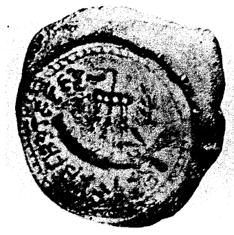
 Terracotta seal depicting ship found in West Bengal, dated between 400 BCE and 100 BCE
The Maritime history of Orissa (Oriya: ଓଡ଼ିଶା, IPA: [oˑɽisaˑ]), also known as Odisha or as Kalinga in ancient times, started before 350 BC according to early sources. The people of this region of eastern India along the coast of the Bay of Bengal sailed up and down the Indian coast, and travelled to Indo China and throughout Maritime Southeast Asia, introducing elements of their culture to the people with whom they traded. By 400 AD, Orissa was the hub of a trade network that stretched from the Roman Empire to China.[citation needed] At one time the Bay of Bengal was known as Kalingodra, or the sea of Kalinga, due to the dominance of Oriya ships.[1] The old traditions are still celebrated in the annual Bali Jatra, or Boita-Bandana festival held for five days in October / November.[2]
Contents
Location
 Approximate boundaries of Kalinga at its greatest extent
Located on the eastern coast of India, the ancient state of Kalinga extended from the Ganga to the Godavari River, including parts of modern West Bengal, Orissa and Andhra Pradesh. The navigable rivers, including the Ganga, Mahanadi, Vamsadhara and Godavari provided access to the interior, where precious and semi-precious stones were found, and their deltas provided natural harbours. From these harbours, the people of the region traded by sea with Ceylon in the south, with Burma in the east, and further afield with the states of the Maritime Southeast Asia, Indochina and China. The maritime activity of Kalinga was so extensive that what is now called the Bay of Bengal was once called the Sea of Kalinga.[3]
The coastline is unstable. The southwest monsoon carries sediment along the coast, at times forming bars and spits that protect the harbours, at other times eroding the protective breakwaters. The rivers carry silt, extending their deltas and filling the former harbours. For this reason, some of the ports named in ancient times are no longer in existence, or have greatly declined.[3] For example, the Chilika Lake was an important harbour, but later became unusable by deep water vessels due to silting.[4]
Some of the ports mentioned by the geographer Ptolemy in the 2nd century AD were Nanigaina (Puri), Katikardama (Kataka) and Kannagara (Konarak). Ptolemy did not refer to the important ports of Manikapatna, Palur, Chelitalo, Kalingapatnam, Pithunda and Khalkatapatna. Writing later in the 9th and 10th centuries AD, Arab sources mention Orissa, Ganjam, Kalinganagar, Keylkan, Al-Lava and Nubin. After the 15th century, ports included Balasore, Pipili, Ganjam, Harishapur, Chandabali and Dhamra.[3]
Early history
 Maurya Empire in 265 BCMain article: History of Orissa
Excavations at Golbai Sasan have shown a Neolithic culture dating to as early as c.2300 BC, followed by a Chalcolithic (copper age) culture and then an Iron age culture starting around 900 BC. Tools found at this site indicate boat building, perhaps for coastal trade.[5] Fish bones, fishing hooks, barbed spears and harpoons show that fishing was an important part of the economy.[3] Some artefacts of the Chalcolithic period are similar to artefacts found in Vietnam, indicating possible contact with Indochina at a very early period.[5]
The Brahmanda Purana describes Chilika as a major harbour where thousands of ships came to trade, coming from Gangasagara, Burma, Malaya, Siam, China, Sumatra, Java, Bali, Borneo and Ceylon.The purana says the ships were protected by sheets of cast copper and propelled by wheels attached to their bottoms driven by a steam engine. Bags that could contain air were inflated or deflated so that the ships could move above or below water.[1]
Early historical sources record that Kalinga became subject to Magadha in 362 BC, regained independence during a civil war in Magadha around 320 BC, but around 261 BC was conquered by the Maurya emperor Ashoka (269 BC to 232 BC).[6] The site at Sisupalagarh, occupied from the 3rd century BC to the 4th century AD, has been identified with Tosali, the provincial capital of Ashoka, and with Kalinganagari, the capital city of Kalinga after it regained independence early in the 1st century BC.[5] The history of the following centuries is complex. At times the north and south of Kalinga were separate states, at times united. Sometimes Kalinga was independent, sometimes it was tributary to a more powerful neighbour.[6]
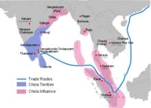 Chola empire c. 1030 AD)
The Bhauma-Kara dynasty ruled over Utkal, as the northern and eastern part of Orissa was then known, from the 8th to 10th centuries AD.[6] These rulers paid tribute to Devapala (810–850 AD), ruler of the Pala Empire of Bengal, but Utkal regained its independence from his successors.[7] For a period, the rulers of Utkal were forced to acknowledge the suzerainty of the Tamil Chola dynasty under their king Rajendra Chola I (1012–1044), with whom they became allied by marriage.[8] After regaining independence, Anantavarma Chodagangadeva (1078–1191) established control over a wide region from the Ganga to the Godavari, moving his capital from Kalinganagar to Cuttack. The power of Orissa waxed and waned over the following centuries, but it was not until 1586 that Orissa finally lost its independence.[6]
Ships
Main article: BoitaIn ancient Orissa there were two types of trading ship, known as common ships and special ships, with the common ships in turn divided into ten categories, and the special ships into two: high and wide ships and long and wide ships. The ships were 8 to 80 meters long, 5 to 25 meters wide, and 3 to 27 meters high.[1] Rules and regulations regarding construction of ships were recorded in the Sanskrit Juktikalpataru. The Madalapanji records that king Bhoja built many ships with local wood.[9] The recovery of many woodworking adzes and other artefacts from Chilika Lake shows that Golabai was a boat-building center.[5]
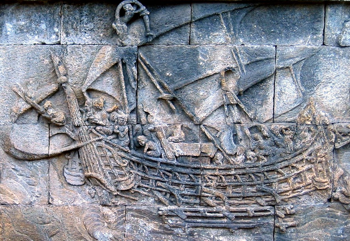
Terracotta seals from Bangarh and Chandraketugarh (400 BC to 100 BC) depict sea going vessels carrying containing corn. The ships have a single mast with a square sail.[3] The earliest depiction of ships in Orissa is in a sculptured frieze showing two ships, found near the Brahmeswar temple, Bhubaneswar, and now preserved in the Orissa State Museum. The first ship has standing elephants in the front part, two people seated in the center and two sailor with oars at the rear steering the ship.[5]
Sea routes
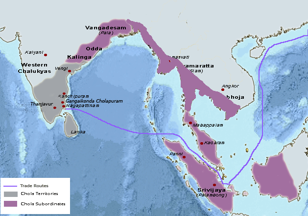
 Sea routes between Kalinga and trading countries
From June to September the summer monsoons blow from the southwest, from Ceylon towards Kalinga. From December to early March, the retreating monsoons blow in the reverse direction.[10] Southeast Asia has similar seasonal wind patterns.[11] Over Indonesia, in July and August the winds blow from Australia in a northwesterly direction, shifting towards a northeasterly direction as they cross the equator. The pattern reverses during January and February.[12] Early navigators would have exploited these seasonal winds, navigating by the stars, the color of the water, the presence of sea snakes, and observation of the flights of sea crows and other homing birds.[13]
The ships of Kalinga were not able to make long sea voyages without stopping along the way for food and water. Ships outbound from Tamralipti would have followed the Burmese coast, stopping at the Nicobar islands, a one month journey. From there, they continued to the southeast, then sailed down the Malay Peninsula and through the strait of Malacca, and onward to Java or Bali, or headed northeast to Indochina or China. An alternative route was southward down the coast of India, perhaps stopping in Ceylon, then southeast to Sumatra.[3]
Trade
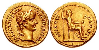
Palur, near the Rushikulya River in the Ganjam district, was an important port in the 2nd century AD. Archaeological exploration has unearthed fragments of Chinese celadon ware, Roman rouletted pottery and amphora pieces, showing that the port carried out significant international trade. An unusual medallion has a Kushana-style king with a Brahmi inscription on one side, and a Roman head with a Roman inscription on the other.[5] A Roman coin of the emperor Tiberius has been found at Salihundam, and other Roman coins have been found at other sites, giving further evidence of trade with the Roman Empire.[3]
Trade with Southeast Asia was established by the 1st century AD, and may have much earlier origins. Later findings include 12th century Ceylonese coins and 14th century Chinese coins. Similar coins from Kotchina in Sumatra point to a triangular trade between Orissa, Ceylon and Sumatra.[3] Trading was not without risks. The kings of Kalinga, Siam and Java had to periodically mount expeditions to put down Malay and Bugis pirates operating in the Straits of Malacca and throughout Maritime Southeast Asia.[14]
Manikapatna was a port on the banks of Chilika that flourished from early historical times until the 19th century AD. Excavations have found many types of pottery from different parts of India, and coins from Ceylon and China. The more modern levels contain Chinese celadon and porcelain, and Arabic glazed pottery. An 18th century Mosque has an inscription saying sailors and traders prayed there before setting out on their voyages.[4]
According to a 6th century AD source, Kalinga was famous for its elephants, for which it found a market in Ceylon, along with precious stones, ivory, pepper, betel nuts and fine textiles. In return, Kalinga imported pearl and silver from Ceylon.[15] Corn and rice were also exported. Traders imported spices and sandalwood from the east, some if it destined for onward transport to the Mediterranean market.[3] A boat depicted in the Sun Temple of Konarak in the 13th century contains a giraffe, indicating trade with Africa, presumably carried on Arab vessels.[5]
Overseas contacts
Burma
Burma went by the name of Kalingarat (Kalinga Rastra) in the 7th century BC, and there is evidence of very early settlement in the southern Mon portion. By the 2nd century AD, the Kalingans were ruling Kalaymyo, the Arakan River valley and Pegu, around the gulf of Martaban. The remains of a ship excavated at Tante, near Yangon is thought to have belonged to Kalingan traders. Place names and similarities in architecture also indicate close contacts across the gulf of Bengal.[16] The Buddhagat, the sacred scripture of Burma, describes trade with the Buddhist merchants of Kalinga, leading to missionaries coming to propagate the faith, and then to political domination of parts of coastal Burma by Kalinga during the 4th to 7th centuries AD. Coins with Hindu symbols found in Pegu confirm this contact.[17]
Java
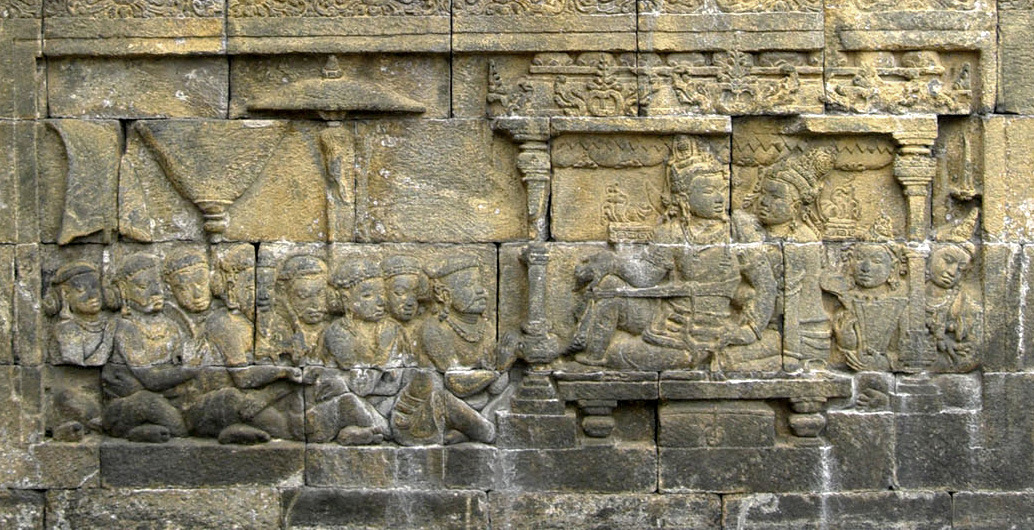
 The bas relief of 8th century Borobudur depict a King and Queen with their subjects, the scene is based on Sailendran royal court.
According to R.D. Banarjee, Hindus from Kalinga took a leading role in establishing Hindu culture in Java. An expedition from Kalinga established a colony in Java in 75 BC.[18] According to legend, there were 20,000 colonists, although this number seems implausible.[19] These immigrants may have introduced the Hindu religion, which was established throughout the island by the 4th century AD.[20]
Chinese historians use the name Ho-Ling (Kalinga) for the leading kingdom of Java in the Tang period (618–906 AD). This kingdom may have been founded by new colonists, or may reflect the rise of the earlier colony to power.[21] Arab historians described the 8th century AD Sailendra dynasty of Java as originating from Kalinga, and said that Sailendra was also powerful in Cambodia and Champa (Annam).[18] A copper plate inscription dated 840 AD says the servants of the inner palace of King Kuti of Java came from Champa and Kalinga. An inscription of the King Airlangga of Java (1019–1042 AD) says people came to his kingdom from Kling (Kalinga) among other places.[22]
Bali
Trade with Bali appears to have started before the Christian Era. Bali had many products that were attractive to Kalinga's traders, including cinnamon, long pepper, white pepper and cardamon, pearls and gems, silk, camphor, bees wax and sandalwood. Traders from Kalinga brought muslin and other fine cloths, rugs, brocade, armour, gold and jewellery. There is a tradition that the first ruler of Bali was an Indian named Kaudinya, around 600 AD, and this name later became the title for future rulers.[23] It is possible that the island is named after Bali, a legendary king of Orissa.[24] Traditional masked dances that are performed in Orissa and Bali for the purpose of removing evils and bringing good fortune have many similarities that point to ancient cultural exchanges.[25] The trade began to decline in the 8th century AD, as Arabs became the predominant maritime power in the region.[26] The festival of "Bali Jatra", or "Journey to Bali", is still celebrated throughout coastal Orissa in memory of the ancient trading links.[27]
Malay peninsula
Through energetic maritime campaigns, the Sailendra kings of Java were able to take control of the Malay Peninsula and part of southern Thailand. The kings welcomed Buddhist missionaries from India, accepting their teaching of the Mahayana sect, which spread through their territories. However, central and northeastern Thailand continued to adhere to the Hinayana teachings of the Theravada sect, which had been introduced by missionaries sent by the emperor Ashoka in the 3rd century BC.[28] Another theory of the introduction of Buddhism to the Malay peninsula is that after Kalinga conquered lower Burma in the 8th century their influence gradually spread down the peninsula.[29] The Malayu language contains many words derived from the Oriya language.[30] In modern Malaysia, Indians are commonly called Klings, a name showing the original influence of Kalinga.[citation needed]
Cambodia
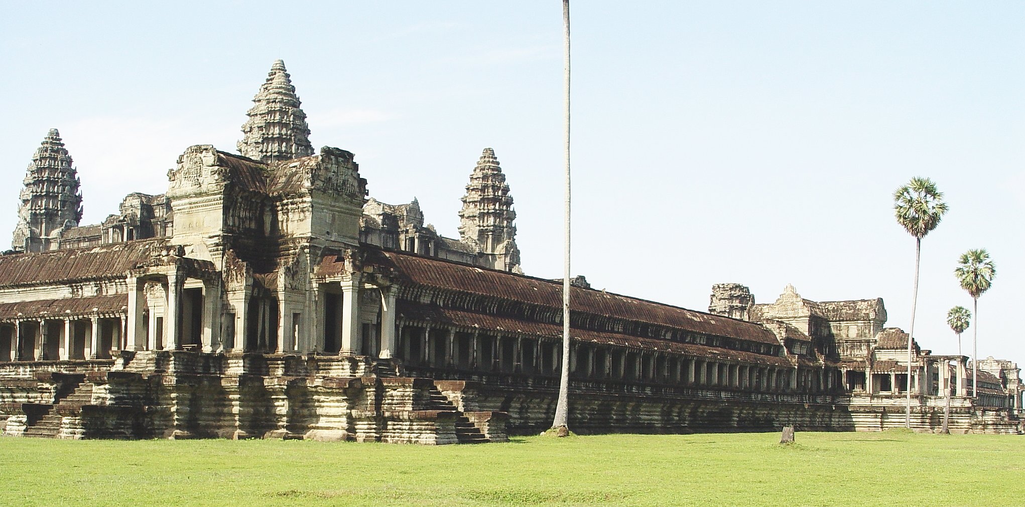
 Angkor Wat viewed from the northwest
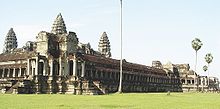
Emigrants from Kalinga came to Cambodia in the 3rd century BC, fleeing from the emperor Asoka. However, after Asoka had converted to Buddhism and sent missionaries to Cambodia, they accepted the teachings and helped establish the religion in the region.[28] The early monuments of the Khmers (of modern Cambodia) appear to be of Andhra origin rather than from Kalinga.[31] However, although some of the inscriptions at Angkor Wat in Cambodia are in Sanskrit, others are in the Kalinga script.[32] The design of the Angkor Wat temple shows influences from Orissa and the Chola of Tamil Nadu.[33]
China
The first record of trade with China is found in the account of Fa Hien (399–411 AD) who sailed in a merchant vessel from the port of Temralipti back to China.[34] The Chinese pilgrim Hieun Tsang (645 CE) tells of sea voyages from the ports of Tamralipta (modern Tamluk) and Chelitalo to Simhala (modern Sri Lanka) and China.[1] A former king of Odra (Orissa) named Subhakararisha, who had abdicated in order to become a monk, voyaged to China in 716 AD. and introduced Tantric Buddhism.[35] There is an account of the carriage by sea in 794 AD of a present by the King of Udra to the Emperor of China.[1] Orissa imported silk from China, and a Chinese coin from the 8th century has been found at Sirpur.[34] Between 813 and 818, three missions were sent from the Javanese nation of Kalinga to the court of Hsien Tung in China, bringing rarities such as a live rhinoceros, a five-coloured parrot and some black boys and girls from East Africa.[36]
Sri Lanka
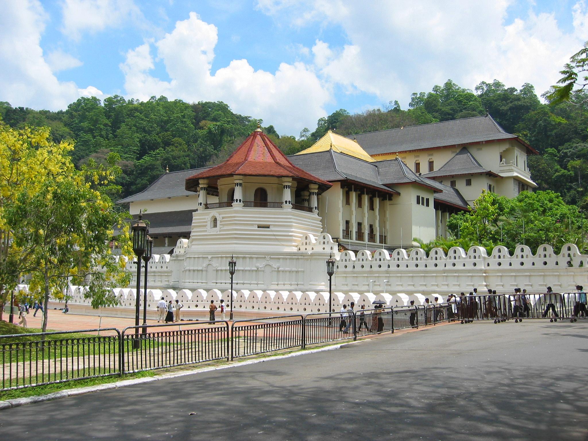
 The Temple of the Tooth Relic in Kandy, Sri Lanka
Kalinga had strong ties with Simhala (Sri Lanka). Some scholars say that the first king of Simhala, Vijaya, came from Simhapura in eastern India, the capital of Kalinga, and that his grandmother was the daughter of the king of Kalinga. The emperor Ashoka sent his son to Ceylon to establish Buddhism, and later sent his daughter Sanghamitra to organise the nuns. The Samantapasadika says that she was accompanied by eight families from Kalinga. The Dathavamsa talks of the friendship between king Guhasiva of Kalinga and king Mahasena of Ceylon (277 – 304 AD). It also talks of the king of Kalinga giving the tooth relic of Gautama Buddha as a dowry to Dantakumara on his marriage to the kings daughter. Dantakumara took the relic to Ceylon where it was enshrined in a stupa.[15]
Hinayanic Buddhism flowered in Ceylon in the 4th and 5th centuries AD, and the influence of scholars from Ceylon spread through Burma, Siam and Cambodia, establishing the beliefs and practices that continue in these countries today. Kalinga was also strongly affected by Ceylonese culture, in particular by the Theravada teachings of Buddhaghosa, since it lay on the route followed by pilgrims from Ceylon visiting holy places in India. Pilgrims from Kalinga sailed to Ceylon to honour the sacred tooth and visit the monasteries.[15] The Chinese pilgrim Hieun Tsang describes these sea voyages from the port of Tamralipta and Chelitalo to Simhala.[1]
According to the Chulavamsa, the king of Kalinga visited Ceylon during the reign of Aggabodhi II (610–611 AD). King Vijayabahu I of Ceylon (1055–1110 AD) married the daughter of the king of Kalinga. Nissanka Malla, son of king Gaparaja of Kalinga became ruler of Ceylon (1187–1196 AD). A prince of Kalinga named Magha invaded Ceylon with a fleet carrying 24,000 soldiers and ruled the island from 1214 to 1235 AD.[15]
Later history
Between the 11th and 16th centuries CE, the name Kalinga was gradually replaced by Odra Desa, Uddisa and eventually Orissa.[3] During the rule of Kapilendradeva (1435–1466 AD) the independent Oriya state established political supremacy over a vast territory outside the limits of geographical Orissa, ruling from the Ganges to Arcot in the south. His successors retained their hold over an extensive territory. During the rule of Prataprudradeva, from 1497 AD to 1541 AD, the kingdom extended from the Hooghly and Midnapore districts of West Bengal to the Guntur district of Andhra Pradesh.[6]
Arabian sailors began to intrude into the Bay of Bengal as early as the 8th century, and later Portuguese, Dutch, English and French ships became dominant, reducing the sailors of Orissa to the coastal trade.[1] In 1586, the Muslim ruler of Bengal, Sulaiman Khan Karrani succeeded in conquering the land, ending its independence. Orissa was subsequently ceded to the Marathas in 1751, and came under British rule during the Second Anglo-Maratha War (1803–1805).[6] Orissa lost much of her maritime trade during the British period (1803–1947). However, the Oriyas stil recall their ancient tradition during their festival of Boita-Vandana, which is approved by the Orissan school of Dharmasastra.[1]
See also
References
- ^ a b c d e f g h Dr. Bhagaban Panda (1997). "Maritime Activities of Orissa". Economic history of Orissa. Indus Publishing. p. 117ff. ISBN 8173870756. http://books.google.ca/books?id=1AA9W9_4Z9gC&pg=PA117.
- ^ "Bali Yatra". Orissa Tourism. http://www.orissatourism.in/Bali-Yatra.html. Retrieved 16 November 2010.
- ^ a b c d e f g h i j Sila Tripati. "Early Maritime Activities of Orissa on the East Coast of India: Linkages in Trade and Cultural Developments". Marine Archaeology Centre, National Institute of Oceanography, Dona Paula, Goa. http://drs.nio.org/drs/bitstream/2264/127/3/Man_Environ_27_117.pdf. Retrieved 17 November 2010.
- ^ a b Sila Tripati and K. H. Vora. "Maritime heritage in and around Chilika Lake, Orissa: Geological evidences for its decline". Marine Archaeology Centre, National Institute of Oceanography, Dona Paula, Goa. http://www.ias.ac.in/currsci/apr102005/1175.pdf. Retrieved 17 November 2010.
- ^ a b c d e f g Sushanta Ku. Patra & Dr. Benudhar Patra. "ARCHAEOLOGY AND THE MARITIME HISTORY OF ANCIENT ORISSA". OHRJ, Vol. XLVII, No. 2. http://orissa.gov.in/e-magazine/Journal/Journal2/pdf/ohrj-014.pdf. Retrieved 16 November 2010.
- ^ a b c d e f "BRIEF HISTORY OF ORISSA". ORISSA REFERENCE ANNUAL – 2005. Orissa Government. http://orissa.gov.in/e-magazine/orissaannualreference/ORA-2005/pdf/brief_history.pdf. Retrieved 18 November 2010.
- ^ "The Eastern Regions". India Times. 21 May 2006. http://o3.indiatimes.com/singurkatha/archive/2009/03/27.aspx. Retrieved 19 November 2010.
- ^ "History of Orissa: The Imperial Gangas". Orissa Government. http://og.csm.co.in/ogv8/orissaprofile/historyr6.asp?img=history. Retrieved 19 November 2010.
- ^ Nirakar Mahalik (September – 2004). "Maritime Trade of Ancient Orissa". Orissa Review. http://kalyan96.googlepages.com/maritimeorissa.pdf. Retrieved 17 November 2010.
- ^ "The Global Monsoon System: Research and Forecast". International Committee of the Third Workshop on Monsoons. http://caos.iisc.ernet.in/faculty/bng/IWM-III-BNG_overview.pdf. Retrieved 20 November 2010.
- ^ "Southeast Asian Climate". Blue Planet Biomes. http://www.blueplanetbiomes.org/se_asian_rnfrstclimate.htm. Retrieved 20 November 2010.
- ^ "Indonesia Climate". Photius Coutsoukis. http://www.photius.com/countries/indonesia/climate/indonesia_climate_climate.html. Retrieved 20 November 2010.
- ^ Himanshu Prabha Ray (2003). The archaeology of seafaring in ancient South Asia. Cambridge University Press. p. 70. ISBN 0521011094. http://books.google.com/books?id=iHHzP4uVpn4C&pg=PA70.
- ^ Royal Society of New Zealand (1873). Transactions of the Royal Society of New Zealand, Volume 5. p. 136. http://books.google.ca/books?id=MQqyvesgLGoC&pg=PA136.
- ^ a b c d Dr. Kandarpa Patel. "MARITIME RELATION OF KALINGA WITH SRILANKA". OHRJ, Vol. XLVII, No. 2. http://orissa.gov.in/e-magazine/Journal/Journal2/pdf/ohrj-017.pdf. Retrieved 17 November 2010.
- ^ Dr. Benudhar Patra (November 2005). "Kalinga and Burma – A Study in Ancient Relations". Orissa Review. http://www.orissa.gov.in/e-magazine/Orissareview/nov2005/engpdf/or-nov-2005.pdf. Retrieved 21 November 2010.
- ^ Radhakumud Mookerji (2006). Indian Shipping – A History of the Sea-Borne Trade and Maritime Activity of the Indians from the Earliest Times (1912). READ BOOKS. p. 145ff. ISBN 1406701238. http://books.google.ca/books?id=gajpz1q57cQC&pg=PA145.
- ^ a b Durga Prasad Patnaik (1989). Palm leaf etchings of Orissa. Abhinav Publications. p. 3. ISBN 8170172489. http://books.google.ca/books?id=90_qAeMT1bwC&pg=PA3.
- ^ Victor M. Fic (2003). From Majapahit and Sukuh to Megawati Sukarnoputri: continuity and change in pluralism of religion, culture and politics of Indonesia from the XV to the XXI century. Abhinav Publications. p. 123. ISBN 817017404X. http://books.google.ca/books?id=CFW1tNel8m0C&pg=RA2-PA123.
- ^ Edward Balfour (1885). The cyclopaedia of India and of eastern and southern Asia, Volume 2. B. Quaritch. p. 426. http://books.google.ca/books?id=yvNWAAAAMAAJ&pg=PA426.
- ^ Krishna Chandra Sagar (2002). An era of peace. Northern Book Centre. p. 68. ISBN 8172111215. http://books.google.ca/books?id=zq6KlY1MnE8C&pg=PA68. Retrieved 19 November 2010.
- ^ R.N. Charkravorty (1985). National Integration in Historical Perspective. Mittal Publications. p. 98. http://books.google.ca/books?id=PItbvfAvVggC&pg=PA98. Retrieved 19 November 2010.
- ^ Wilhelm von Pochhammer (2005). India's Road to Nationhood. Allied Publishers. p. 146. ISBN 8177647156. http://books.google.ca/books?id=_up9jsn0ILkC&pg=PA146.
- ^ Sir William Wilson Hunter (1872). Orissa, Volume 1. Smith, Elder & co.. p. 217. http://books.google.ca/books?id=8vURAAAAYAAJ&pg=PA217.
- ^ John Emigh (1996). Masked performance: the play of self and other in ritual and theatre. University of Pennsylvania Press. p. 74. ISBN 081221336X. http://books.google.ca/books?id=7TNTTi1-fJ8C&pg=PA74.
- ^ Kartik Chandra Roy, Srikanta Chatterjee. Growth, development and poverty alleviation in the Asia-Pacific. Nova Publishers, 2006. p. 17ff. ISBN 1594549311. http://books.google.ca/books?id=DHZ64zYxZZQC&pg=PA17.
- ^ G.N. Das (1998). One World One Family. Abhinav Publications. pp. 31–32. ISBN 8170173728. http://books.google.ca/books?id=uiFEaJH8DXQC&pg=PA31.
- ^ a b Promsak Jermsawatdi (1979). Thai art with Indian influences. Abhinav Publications. p. 24. ISBN 8170170907. http://books.google.ca/books?id=0O9je9dECH8C&pg=PA24.
- ^ A Concise History of Buddhist Art in Siam. CUP Archive. http://books.google.ca/books?id=75M3AAAAIAAJ&pg=PA45.
- ^ Reinhold Rost, Royal Asiatic Society of Great Britain and Ireland. Straits Branch (1886). Miscellaneous papers relating to Indo-China: reprinted for the Straits Branch of the Royal Asiatic Society from Dalrymple's "Oriental Repertory," and the "Asiatic Researches" and "Journal" of the Asiatic Society of Bengal, Volume 1. Trübner & Co.. p. 92. http://books.google.ca/books?id=rwsYAAAAYAAJ&pg=PA92.
- ^ Nadimpalli Venkata Bala Subrahmanya Dutt (1993). Yayoi people and ancient Indo-Japanese relations. Northern Book Centre. p. 45. ISBN 8172110480. http://books.google.ca/books?id=MTLE-pvn-lQC&pg=PA45.
- ^ Robert Needham Cust (1880). Linguistic and oriental essays: Written from the year 1840 to 1903. Trübner & co.. http://books.google.ca/books?id=Cyy23uu5b7MC&pg=PA406.
- ^ Freeman, Michael and Jacques, Claude (1999). Ancient Angkor. River Books. p. 48. ISBN 0-8348-0426-3.
- ^ a b Nihar Ranjan Patnaik (1997). Economic history of Orissa. Indus Publishing. p. 133. ISBN 8173870756. http://books.google.ca/books?id=1AA9W9_4Z9gC&pg=PA133.
- ^ Thomas E. Donaldson (2001). Iconography of the Buddhist Sculpture of Orissa: Text. Abhinav Publications. p. 6. ISBN 8170174066. http://books.google.ca/books?id=DbxE8zOuRbUC&pg=PA6.
- ^ Edward H. Schafer (1963). The golden peaches of Samarkand: a study of Tʻang exotics. University of California Press. p. 47. ISBN 0520054628. http://books.google.ca/books?id=jqAGIL02BWQC&pg=PA47.
Categories:- Maritime history of India


Wikimedia Foundation. 2010.