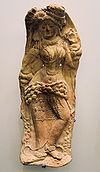
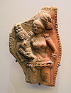
- Chandraketugarh
-
Chandraketugarh is an archaeological site located beside the Bidyadhari river, about 35 km north-east of Kolkata, India, in the district of North 24 parganas, near the township of Berachampa and the Haroa Road railhead.
Years of excavation have revealed relics of several historical periods, although the chronological classification of the relics remains incomplete.
Finds include Northern Black Polished Ware (NBPW) relics, later wares dated from about 400 BC to 100 BC and approximately contemporary with the Maurya period, as well as artifacts from the more recent Kushanas and Gupta periods.
According to some historians, the Chandraketugarh site and surrounding area could be the place known to ancient Greek and Roman writers as 'Gangaridai'.[citation needed]
References
- Chandraketugarh : A Treasure House of Bengal Terracottas - Enamul Haque. Dhaka, The International Centre for Study of Bengal Art, 2001, 416 p., 678 illustrations including 400 in colour, figures, plates, maps, ISBN 984-8140-02-6. [1]
- Chandraketugarh : A Lost Civilization - Gourishankar De and Shubhradip De. Kolkata, Sagnik Books, 2004, 109 p., 34 photos, [2]
Places in Bengal that no longer exist Betor · Chandraketugarh · Devkot · Dihar · Gobindapur · Gaur (Lakhsmanabati) · Kalikata · Karnasubarna · Mahasthangarh · Mainamati · Noapara-Ishanchandranagar · Paharpur (Somapura Mahavihara) · Pandu Rajar Dhibi · Pandua · Saptagram · Sonargaon · Sutanuti · Tamralipta · Wari-Bateshwar
North 24 Parganas district topics General Bibhutibhushan Wildlife Sanctuary • Dakshineswar Kali Temple • Gangaridai • Kanchrapara Airfield · Marichjhanpi · Sundarbans • Sundarban National Park • West Bengal State University • Kripamayee Kali TempleSubdivisions Bangaon • Barrackpore • Barasat Sadar • Basirhat • BidhannagarLocations
other than cities and townsMunicipalities Ashoknagar Kalyangarh • Baduria • Baranagar • Barasat • Barrackpore • Basirhat • Bhatpara • Bidhannagar • Garulia • Gobardanga • Habra • Halisahar • Kamarhati • Kanchrapara • Khardaha • Madhyamgram • Naihati • North Barrackpur • North Dumdum • Panihati • Rajarhat • South Dumdum • Taki • TitagarhCommunity development blocks Barasat Sadar subdivision Amdanga • Deganga • Barasat I • Barasat II • Habra I • Habra II • Rajarhat Basirhat subdivision Baduria • Basirhat I • Basirhat II • Haroa • Hasnabad • Hingalganj • Minakhan • Sandeshkhali I • Sandeshkhali II • Swarupnagar Bangaon subdivision Bagdah • Bangaon • Gaighata Barrackpore subdivision Barrackpore I • Barrackpore IIRivers Transport NH 34 • NH 35 • Belghoria Expressway • Jubilee Bridge • Vivekananda Setu • Nivedita Setu • Netaji Subhash Chandra Bose International Airport • Barasat Basirhat Railway • Eastern Railway • Kolkata Suburban Railway • List of bus routes in KolkataLok Sabha constituencies Vidhan Sabha constituencies Bagda • Bangaon Uttar • Bangaon Dakshin • Gaighata • Swarupnagar • Baduria • Habra • Ashoknagar • Amdanga • Bijpur • Naihati • Bhatpara • Jagatdal • Noapara • Barrackpore • Khardaha • Dum Dum Uttar • Panihati • Kamarhati • Baranagar • Dum Dum • Rajarhat New Town • Bidhannagar • Rajarhat Gopalpur • Madhyamgram • Barasat • Deganga • Haroa • Minakhan • Sandeshkhali • Basirhat Dakshin • Basirhat Uttar • HingalganjFormer Vidhan Sabha constituencies Titagarh • HasnabadSee also Cities and towns in North 24 Parganas district • People from North 24 Parganas districtOther districts in West Bengal Bankura • Bardhaman • Birbhum • Cooch Behar • Dakshin Dinajpur • Darjeeling • Hooghly • Howrah • Jalpaiguri • Kolkata • Malda • Murshidabad • Nadia • Paschim Medinipur • Purba Medinipur • Purulia • South 24 Parganas • Uttar DinajpurSurrounding areas outside West Bengal Bangladesh Khulna DivisionCategories:- Former populated places in India
- Archaeological sites in West Bengal
- West Bengal geography stubs
- Indian history stubs
Wikimedia Foundation. 2010.


