- Dunraven Peak
-
Dunraven Peak Elevation 9,869 ft (3,008 m) [1] Location Location Yellowstone National Park, Park County, Wyoming Range Washburn Range Coordinates 44°46′58″N 110°28′10″W / 44.78278°N 110.46944°WCoordinates: 44°46′58″N 110°28′10″W / 44.78278°N 110.46944°W[1] Topo map Mount Washburn Dunraven Peak el. 9,869 feet (3,008 m) is a mountain peak in the Washburn Range of Yellowstone National Park. In 1874, just two years after the park's creation, the Earl of Dunraven, a titled Englishman made a visit to Yellowstone in conjunction with a hunting expedition to the Northern Rockies. He was so impressed with the park, that he devoted well over 150 pages to Yellowstone in his The Great Divide, published in London in 1874. The Great Divide was one of the earliest works to praise and publicize the park.
In 1878 during a U.S. Geological Survey of the park, Henry Gannett, a geographer working with the survey, named a peak just two miles southwest of Mount Washburn in the honor of the Earl of Dunraven and the service his book had done for the park. In 1879, Philetus Norris, the park superintendent gave a pass on the Grand Loop Road between Tower and Canyon the name Dunraven Pass because of its proximity to Dunraven Peak[2].
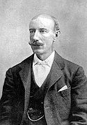
Images of Dunraven Peak Duraven Peak's namesake, Earl of DunravenSee also
Notes
- ^ a b "Dunraven Peak". Geographic Names Information System, U.S. Geological Survey. http://geonames.usgs.gov/pls/gnispublic/f?p=gnispq:3:::NO::P3_FID:1587932.
- ^ Haines, Aubrey L. (1996). Yellowstone Place Names-Mirrors of History. Niwot, Colorado: University Press of Colorado. pp. 104–106. ISBN 087081382X.
Geography, historic structures and other attractions in the Tower Roosevelt and Lamar Valley areasStructures and History Grand Loop Road Historic District • John F. Yancey • Lamar Buffalo Ranch • Northeast Entrance Station • Roosevelt Lodge Historic District • Yanceys, Wyoming
Geography and Geology Abiathar Peak • Barronette Peak • Beartooth Highway • Cooke City, Montana • Cook Peak • Druid Peak • Dunraven Pass • Dunraven Peak • Folsom Peak • Hedges Peak • Lamar River • Mount Hornaday • Mount Norris • Mount Washburn • Prospect Peak • Slough Creek (Wyoming) • Soda Butte Creek • Specimen Ridge • The Thunderer • Tower Fall • Trout Lake (Wyoming) • Yellowstone RiverList of Yellowstone National Park related articles
 Media related to Nature of Yellowstone National Park at Wikimedia Commons
 State of Wyoming
Topics - Governors
- Delegations
- Geography
- Government
- History
- People
- Visitor Attractions
- State Symbols
- Radio Stations
Society - Crime
- Demographics
- Economy
- Education
- Politics
Regions Cities Counties Categories:- Mountains of Wyoming
- Mountains of Yellowstone
Wikimedia Foundation. 2010.

