- Druid Peak
-
Druid Peak 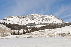
January 2010Elevation 9,577 ft (2,919 m) [1] Location Location Yellowstone National Park,
Park County, Wyoming, USARange Absaroka Range Coordinates 44°54′16″N 110°10′45″W / 44.90444°N 110.17917°WCoordinates: 44°54′16″N 110°10′45″W / 44.90444°N 110.17917°W[1] Druid Peak (elevation 9,577 feet (2,919 m)) is a moderate domed peak on the southern flank of the Absaroka Range in Yellowstone National Park. The peak lies just north of the Lamar River and Soda Butte Creek confluence at the head of the Lamar Valley. Prior to 1885, this summit was named Soda Hill by members of the Hayden Geological Survey of 1878 and Mount Longfellow or Longfellows' Peak by then park superintendent Philetus Norris in 1880. In 1885, members of the Arnold Hague Geological Survey changed the name to Druid Peak for unknown reasons, but some historians believe it may have been the presence of Stonehenge like rock formations on its eastern face that prompted the name.[2]
Druid Peak is notable for its role in the reintroduction of Wolves into Yellowstone. Rose Creek which flows west from the northern slope of Druid Peak was the site of one of the release pens for the January 1995 release of wolves, the pack to be known as the Rose Creek pack. In January 1996 a second release was made from pens on the slopes of Druid Peak. This pack became known as the Druid Pack.[3][4]
See also
Notes
- ^ a b "Druid Peak". Geographic Names Information System, U.S. Geological Survey. http://geonames.usgs.gov/pls/gnispublic/f?p=gnispq:3:::NO::P3_FID:1609245. Retrieved 2010-01-31.
- ^ Whittlesey, Lee (1996). Yellowstone Place Names. Gardiner, MT: Wonderland Publishing Company. p. 91. ISBN 1599717166.
- ^ Phillips, Michael K and Smith Douglas W. (1997). Yellowstone Wolf Project-Biennial Report 1995–96 (Report). National Park Service. http://www.nps.gov/yell/naturescience/upload/wolfrep95-96.pdf.
- ^ Smith, Douglas W. (1998). Yellowstone Wolf Project—Annual Report 1997 (Report). National Park Service. http://www.nps.gov/yell/naturescience/upload/wolf97.pdf.
Geography, historic structures and other attractions in the Tower Roosevelt and Lamar Valley areasStructures and History Grand Loop Road Historic District • John F. Yancey • Lamar Buffalo Ranch • Northeast Entrance Station • Roosevelt Lodge Historic District • Yanceys, Wyoming
Geography and Geology Abiathar Peak • Barronette Peak • Beartooth Highway • Cooke City, Montana • Cook Peak • Druid Peak • Dunraven Pass • Dunraven Peak • Folsom Peak • Hedges Peak • Lamar River • Mount Hornaday • Mount Norris • Mount Washburn • Prospect Peak • Slough Creek (Wyoming) • Soda Butte Creek • Specimen Ridge • The Thunderer • Tower Fall • Trout Lake (Wyoming) • Yellowstone RiverList of Yellowstone National Park related articles
 Media related to Nature of Yellowstone National Park at Wikimedia Commons
 State of Wyoming
Topics - Governors
- Delegations
- Geography
- Government
- History
- People
- Visitor Attractions
- State Symbols
- Radio Stations
Society - Crime
- Demographics
- Economy
- Education
- Politics
Regions Cities Counties Categories:- Mountains of Wyoming
- Mountains of Yellowstone

Wikimedia Foundation. 2010.