- Courthouse (Colonial Williamsburg)
-
Colonial Williamsburg Courthouse
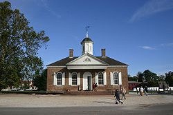 The courthouse in Colonial Williamsburg

Location: Duke of Gloucester Street between Palace Green and Queen Street Coordinates: 37°16′7.3″N 76°42′0.7″W / 37.268694°N 76.700194°WCoordinates: 37°16′7.3″N 76°42′0.7″W / 37.268694°N 76.700194°W Built: 1771 Architectural style: Georgian style Governing body: Local Part of: Williamsburg Historic District (#66000925) Designated CP: October 15, 1966[1] The Colonial Williamsburg Courthouse was constructed from 1770-1771 in the Georgian style. The courthouse is located facing Market Square with Duke of Gloucester Street running directly behind it. The property was acquired by Colonial Williamsburg in 1928, and was added to the National Register as a contributing property to the Williamsburg Historic District on October 15, 1966.
The courthouse once housed two separate court systems, one being the James City County Court, responsible for carrying out county cases, and the other, the Hustings Court, responsible for the city cases. The courthouse was built with red bricks with white wooden trim-boards and long arched windows with white shutters. A projected portico is located over one of the entrances and is unique in Georgian architecture. The hipped roof rests on an entablature with dentil moldings. The roof is pierced on both sides by a chimney and a central octagonal drum capped with a dome and a spire.
The courthouse was the site where Benjamin Waller read aloud the Declaration of Independence on July 25, 1776, after it arrived from Philadelphia.[2]
The building was used as a hospital for the Confederate Army after the Battle of Williamsburg.
References
- ^ "National Register Information System". National Register of Historic Places. National Park Service. 2006-03-15. http://nrhp.focus.nps.gov/natreg/docs/All_Data.html.
- ^ http://www.colonialwilliamsburg.com/almanack/places/hb/hbcourt.cfm
Further reading
- Beney, Peter; The Majesty of Colonial Williamsburg; Pelican Books; Gretna, Louisiana; 1997 ISBN 0-88289-993-7
Colonial Williamsburg HISTORYBattle of Williamsburg • Colonial Williamsburg History • Historic Triangle • Middle Plantation • Rich Neck Plantation
STRUCTURESAbby Aldrich Rockefeller Folk Art Museum • Alexander Craig House • Bassett Hall • Bruton Parish Church • Capitol • Charlton House • Courthouse • DeWitt Wallace Decorative Arts Museum • Governor's Palace • James Semple House • John Crump House • Nicolson Store • Palmer House • Peyton Randolph House • Raleigh Tavern • St. George Tucker House • Wetherburn's Tavern • Wren Building • Wythe House
GEOGRAPHYU.S. National Register of Historic Places Topics Lists by states Alabama • Alaska • Arizona • Arkansas • California • Colorado • Connecticut • Delaware • Florida • Georgia • Hawaii • Idaho • Illinois • Indiana • Iowa • Kansas • Kentucky • Louisiana • Maine • Maryland • Massachusetts • Michigan • Minnesota • Mississippi • Missouri • Montana • Nebraska • Nevada • New Hampshire • New Jersey • New Mexico • New York • North Carolina • North Dakota • Ohio • Oklahoma • Oregon • Pennsylvania • Rhode Island • South Carolina • South Dakota • Tennessee • Texas • Utah • Vermont • Virginia • Washington • West Virginia • Wisconsin • WyomingLists by territories Lists by associated states Other  Category:National Register of Historic Places •
  Portal:National Register of Historic PlacesCategories:
- Historic district contributing properties
- County courthouses in Virginia
- National Historic Landmarks in Virginia
- Colonial Williamsburg
- Historic districts in Virginia
- 1771 architecture
- Courthouses in Virginia
- Courthouses on the National Register of Historic Places in Virginia


Wikimedia Foundation. 2010.