- Cottonwood Ranch
-
- This article is about the ranch in Kansas, United States. For the historical ranch in the Cariboo region of British Columbia, Canada, see Cottonwood, British Columbia.
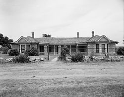
John Fenton Pratt Ranch Front of the ranch house
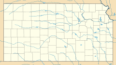
Location: Valley Township, Sheridan County, Kansas, USA Nearest city: Morland, Kansas Coordinates: 39°21′20″N 100°10′25″W / 39.35556°N 100.17361°WCoordinates: 39°21′20″N 100°10′25″W / 39.35556°N 100.17361°W Architect: John Fenton Pratt Governing body: State NRHP Reference#: 83000442[1] Added to NRHP: April 28, 1983 The Cottonwood Ranch is an historic site near Studley in Valley Township, Sheridan County, Kansas, United States.[2] The ranch is now preserved as a Kansas State Historic Site.
The ranch was built by Abraham Pratt, an Englishman who first came to the United States during the years of the Colorado Gold Rush. After returning to England, he immigrated to Kansas with his sons John Fenton and Tom and settled in the Studley vicinity. Beginning in 1885, the men built a one-room stone house with a sod roof and dirt floor. After it proved inadequate for shelter from the winter conditions, it was re-roofed with wood, and it was expanded in later years. Other buildings at the ranch included a sod stable, a sod-walled corral, and a wood-framed outbuilding with a toilet. A storage cistern was constructed to store water from a natural spring on the property.[3]
In 1983, the ranch property was listed on the National Register of Historic Places as the John Fenton Pratt Ranch.[1]
References
- ^ a b "National Register Information System". National Register of Historic Places. National Park Service. 2009-03-13. http://nrhp.focus.nps.gov/natreg/docs/All_Data.html.
- ^ DeLorme. Kansas Atlas & Gazetteer. 4th ed. Yarmouth: DeLorme, 2009, p. 31. ISBN 0-89933-342-7.
- ^ Cottonwood Ranch State Historic Site History, Kansas State Historical Society, 2009. Accessed 2009-05-07
External links
- Cottonwood Ranch State Historic Site, Kansas State Historical Society.
U.S. National Register of Historic Places Topics Lists by states Alabama • Alaska • Arizona • Arkansas • California • Colorado • Connecticut • Delaware • Florida • Georgia • Hawaii • Idaho • Illinois • Indiana • Iowa • Kansas • Kentucky • Louisiana • Maine • Maryland • Massachusetts • Michigan • Minnesota • Mississippi • Missouri • Montana • Nebraska • Nevada • New Hampshire • New Jersey • New Mexico • New York • North Carolina • North Dakota • Ohio • Oklahoma • Oregon • Pennsylvania • Rhode Island • South Carolina • South Dakota • Tennessee • Texas • Utah • Vermont • Virginia • Washington • West Virginia • Wisconsin • WyomingLists by territories Lists by associated states Other Categories:- Historic sites in the United States
- National Register of Historic Places in Kansas
- Ranches in the United States
- Museums in Sheridan County, Kansas
- Kansas state historic sites
- Historic house museums in Kansas
Wikimedia Foundation. 2010.

