- Coal Creek Historic Mining District
-
Coal Creek Historic Mining District
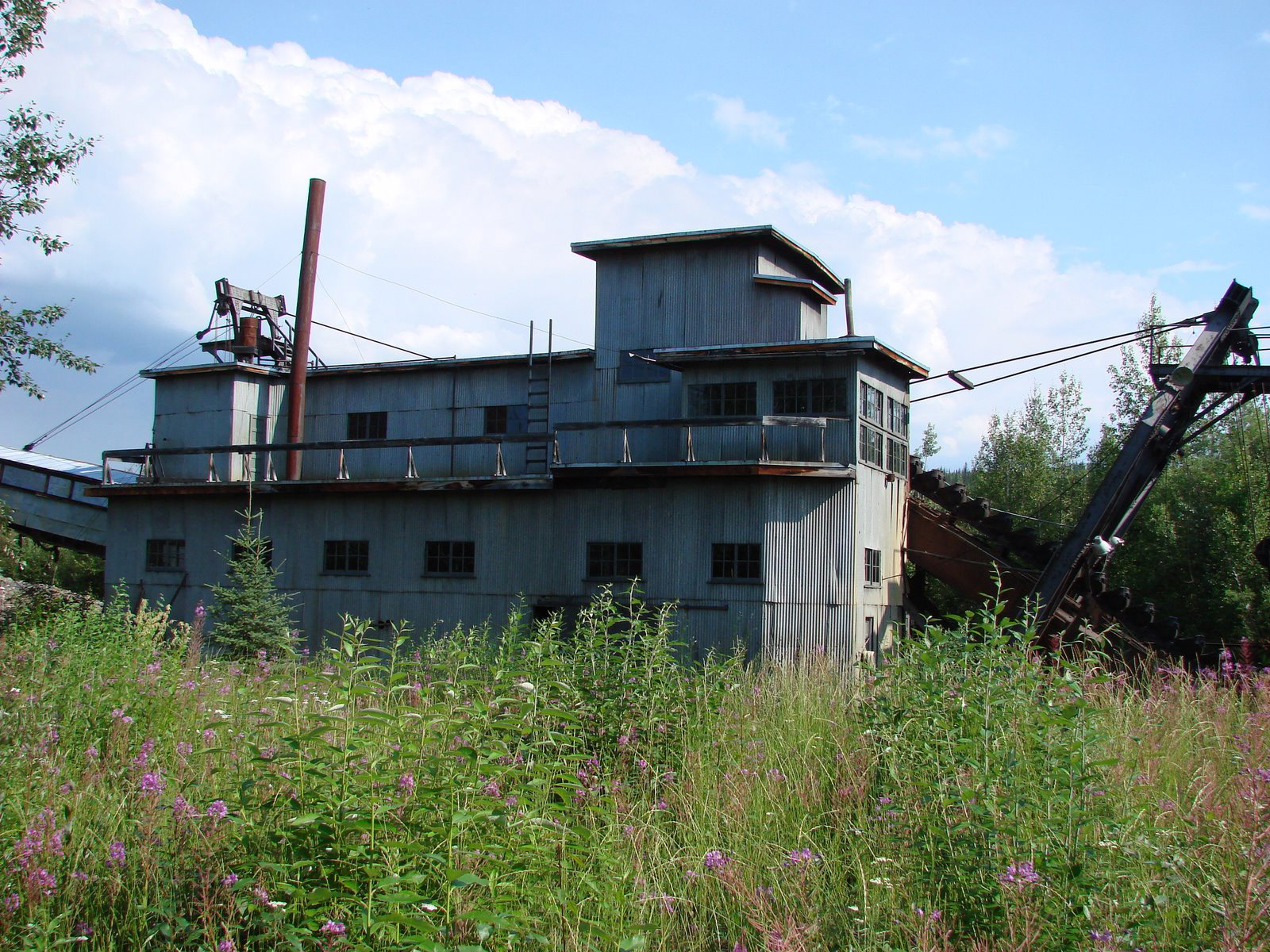
 Coal Creek Dredge

Nearest city: Circle, Alaska Coordinates: 65°18′29″N 143°11′27″W / 65.30806°N 143.19083°WCoordinates: 65°18′29″N 143°11′27″W / 65.30806°N 143.19083°W Built: 1933 Architect: Patty, Ernest N.; et al. Architectural style: No Style Listed Governing body: National Park Service MPS: Yukon River Lifeways TR NRHP Reference#: 95000573 Added to NRHP: May 04, 1995[1] The Coal Creek Historic Mining District is a gold-mining area in the Yukon-Charley Rivers National Preserve of Alaska. It features a gold dredge and a supporting community of several dozen buildings, established by mining entrepreneur Ernest Patty.[2]
The dredge is the most significant relic in the district. It is a medium-sized diesel-powered floating dredge. It was built by the Walter W. Johnson Company of Oakland, California and shipped in pieces to Skagway, then by rail to Whitehorse, Yukon Territory and by barge down the Yukon River.[3]
The encampment moved three times. It was first established near the mouth of Cheese Creek in 1934, then moved to a location near Snare Creek in 1941. The final move brought it to its present location at Beaton Pup. The first site has not survived, having been dredged over. The second site has been altered by changes in the course of the creek. The Frank Slaven Roadhouse, separately listed on the National Register of Historic Places, is nearby and is included in the district. The third camp survives nearly intact, with its equipment and historic context preserved.[3]
The placer operation was managed by mining engineer Ernest Patty, who arrived in Alaska in 1922 and had become an instructor at the University of Alaska in Fairbanks. Patty was to return to what had become the University of Alaska in 1953 as president of the university, retiring in 1960.[3]
See also
- Chatanika gold dredge (Fairbanks)
- F. E. Company Dredge No. 4
- Goldstream Dredge No. 8
References
- ^ "National Register Information System". National Register of Historic Places. National Park Service. 2008-04-15. http://nrhp.focus.nps.gov/natreg/docs/All_Data.html.
- ^ "Coal Creek Dredge". List of Classified Structures. National Park Service. 2008-11-24. http://www.hscl.cr.nps.gov/insidenps/report.asp?STATE=AK&PARK=YUCH&STRUCTURE=&SORT=&RECORDNO=21.
- ^ a b c Historical Research Associates (June, 1984). National Register of Historic Places Inventory-Nomination: Coal Creek Historic Mining DistrictPDF (1.62 MB). National Park Service.
U.S. National Register of Historic Places Topics Lists by states Alabama • Alaska • Arizona • Arkansas • California • Colorado • Connecticut • Delaware • Florida • Georgia • Hawaii • Idaho • Illinois • Indiana • Iowa • Kansas • Kentucky • Louisiana • Maine • Maryland • Massachusetts • Michigan • Minnesota • Mississippi • Missouri • Montana • Nebraska • Nevada • New Hampshire • New Jersey • New Mexico • New York • North Carolina • North Dakota • Ohio • Oklahoma • Oregon • Pennsylvania • Rhode Island • South Carolina • South Dakota • Tennessee • Texas • Utah • Vermont • Virginia • Washington • West Virginia • Wisconsin • WyomingLists by territories Lists by associated states Other  Category:National Register of Historic Places •
  Portal:National Register of Historic PlacesCategories:
- Historic districts in Alaska
- National Register of Historic Places in Alaska
- Geography of Yukon–Koyukuk Census Area, Alaska
- Alaska Registered Historic Place stubs

Wikimedia Foundation. 2010.