- St Mary's Church, Penwortham
-
St Mary's Church, Penwortham 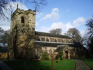
St Mary's Church, Penwortham, from the southwestLocation in Lancashire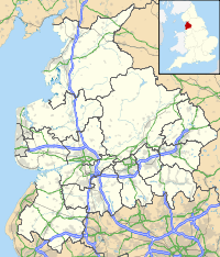
 St Mary's Church, Penwortham
Coordinates: 53°45′19″N 2°43′24″W / 53.7552°N 2.7234°W OS grid reference SD 524 290 Location Church Avenue, Penwortham, Lancashire Country England Denomination Anglican Website St Mary, Penwortham Architecture Status Parish church Functional status Active Heritage designation Grade II* Designated 11 November 1966 Architect(s) E. G. Paley
(rebuilding of nave and aisles)Architectural type Church Style Gothic, Gothic Revival Specifications Materials Stone, slate roof Administration Parish Penwortham Deanery Leyland Archdeaconry Blackburn Diocese Blackburn Province York Clergy Vicar(s) Revd Chris Nelson Laity Churchwarden(s) David Thornton, James Barton Flower guild Iris Boyne St Mary's Church, Penwortham is located in Church Avenue, Penwortham, Lancashire, England. It is an active Anglican parish church in the deanery of Leyland, the archdeaconry of Blackburn, and the diocese of Blackburn.[1] The church has been designated by English Heritage as a Grade II* listed building.[2]
Contents
History
The oldest part of the church is the chancel which dates from the 14th century. The west tower was built in the 15th century.[2] The nave and aisles were rebuilt in 1855–56 by the Lancaster architect E. G. Paley.[3] As part of the restoration the roof was raised, and the north and west galleries were removed.[4] Between 2009 and 2011 the church was reordered, under-floor heating was installed, and the pews were replaced by chairs.[1]
Architecture
Exterior
St Mary's is constructed in stone and has a slate roof. Its plan consists of a four-bay nave with north and south aisles, a south porch, a chancel, and a west tower. The tower has diagonal buttresses and a battlemented parapet with pinnacles. On its west side is a doorway, above which is a three-light window with Perpendicular tracery. Over the window is a niche with an ogee head and crocketed pinnacles. The bell openings have two lights and are louvred. On the sides of the nave are five two-light windows. There is a blocked priest's door in the south wall of the chancel, above which is a stone inscribed with the date 1653.[2]
Interior
Inside the church, the arcades are carried on alternate round and octagonal piers. The font is dated 1667; it is square with chamfered corners, and stands on a square pillar. The memorial tablets include one to the cotton manufacturer and politician John Horrocks who died in 1804.[2] There are fragments of early stained glass in the chancel windows.[2] Before the reordering of 2009–11 there were box pews of 1855 in the church, those in the aisles being arranged to face the centre of the church, rather than to the east end.[3] The organ is in the west gallery, and was installed there in 1959 by Jardines of Manchester.[4] The ring consists of eight bells, all of which were cast in 1965 by Mears & Stainbank at the Whitechapel Bell Foundry.[5]
External features
In the churchyard are four structures that have been designated as Grade II listed buildings. One of these is a gravestone dated 1682,[6] and another is a gravestone dated 1686.[7] To the south of the church is a sundial dated 1815.[8] John Horrocks has a second memorial, this being his tomb chest in the churchyard; it is also a memorial to other members of his family.[9]
See also
- List of ecclesiastical works by E. G. Paley
References
- ^ a b St Mary, Penwortham, Church of England, http://www.achurchnearyou.com/penwortham-st-mary/, retrieved 23 August 2011
- ^ a b c d e Church of St Mary, Penwortham (1073058). National Heritage List for England. English Heritage. Retrieved 23 August 2011.
- ^ a b Pevsner, Nikolaus (2002) [1969], North Lancashire, The Buildings of England, New Haven and London: Yale University Press, p. 499, ISBN 0-300-09617-8
- ^ a b St Mary's History, St Mary's in Penwortham, http://www.penwortham-stmary.co.uk/our_history.htm, retrieved 23 August 2011
- ^ Penwortham, S Mary, Dove's Guide for Church Bell Ringers, http://dove.cccbr.org.uk/detail.php?searchString=Penwortham&Submit=+Go+&DoveID=PENWORTHAM, retrieved 23 August 2011
- ^ Stone slab 1 metre north of chancel of Church of St Mary, Penwortham (1210839). National Heritage List for England. English Heritage. Retrieved 23 August 2011.
- ^ Gravestone 2 metres from southeast of chancel of Church of St Mary, Penwortham (1073059). National Heritage List for England. English Heritage. Retrieved 23 August 2011.
- ^ Sundial 2 metres south of tower of Church of St Mary, Penwortham (1210834). National Heritage List for England. English Heritage. Retrieved 23 August 2011.
- ^ Tomb chest circa 5 metres south of chancel of Church of St Mary, Penwortham (1361872). National Heritage List for England. English Heritage. Retrieved 23 August 2011.
Categories:- Church of England churches in Lancashire
- Diocese of Blackburn
- Grade II* listed churches
- Grade II* listed buildings in Lancashire
- English Gothic architecture
- Gothic Revival architecture in England
- E. G. Paley buildings
- Religious buildings completed in 1856


Wikimedia Foundation. 2010.