- Church of St Leonard the Less, Samlesbury
-
St Leonard the Less, Samlesbury 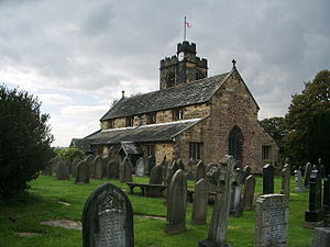
Location in Lancashire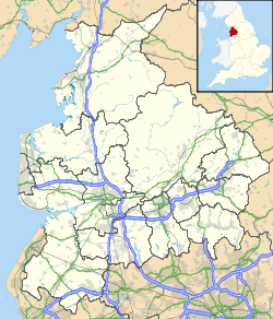

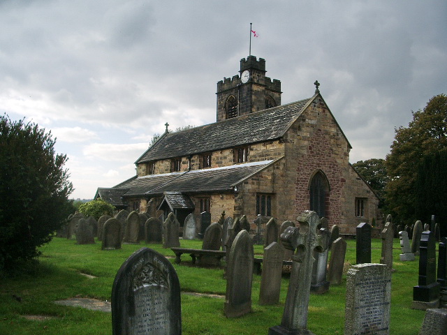
Coordinates: 53°46′05″N 2°37′25″W / 53.7680°N 2.6237°W OS grid reference SD 5898430362 Location Samlesbury, Lancashire Denomination Anglican Architecture Functional status Active Heritage designation Grade I Designated 11 November 1966 Administration Deanery Leyland Archdeaconry Blackburn Diocese Blackburn Province York The Church of St Leonard the Less is an Anglican church in the village of Samlesbury, Lancashire, England, situated close to the banks of the River Ribble. It is an active parish church in the Diocese of Blackburn. It dates predominantly from 1558, with a tower added 1899–1900, and has been designated a Grade I listed building by English Heritage.
Contents
History
There has been a church (or chapel) on the site since the 12th century, traces of which can be seen in the present structure.[1] The chapel may have been rebuilt in the 14th century. It was substantially rebuilt in 1558, by Edward Stanley, 3rd Earl of Derby and was restored in 1885.[2][3] The tower was added in 1899–1900 by James Bertwistle of Blackburn.[2] The church was designated a Grade I listed building by English Heritage on 11 November 1966. The Grade I listing is for buildings "of exceptional interest, sometimes considered to be internationally important".[4]
Architecture
Exterior
St Leonard's is constructed of yellow sandstone, with older parts in red sandstone, and stone slate roofs.[1] Its plan consists of a clerestoried nave and chancel under one roof with aisles to the north and south, and a tower to the north-west.[3] The 19th century east window is a three lights window with a pointed head.[3] The west window (perhaps also 19th century)[2] has a pointed arch with three pointed lights and crossed mullions.[1] Most of the remaining windows are square-headed with three rounded lights.[1]
The tower is ashlar. It has diagonal buttresses and a crenellated parapet.[3] It has a turret with a spiral staircase.[1] There is a clock on the west wall and belfry louvres on all walls.[3]
Interior and fittings
Together, the nave and chancel measure 66 feet (20 m) by 18 feet 6 inches (5.64 m).[1] The internal walls, rough coursed masonry, were plastered at one time, but this was removed in the 19th century.[3] There is a piscina in the south wall of the sanctuary.[1] The arcades have four bays with pointed arches. The piers are octagonal. At the west end of the south aisle is a baptistery, concealed by an oak screen.[1]
There are elaborate box pews from the 16th and 17th centuries, the earliest from 1678.[2] The double-decker pulpit is in the north end of the nave.[1] There is funerary armour dating from 1546 of Thomas Southworth of Samlesbury Hall.[2]
Churchyard
There is a sundial a few feet south-east of the church, with a plate that dates from 1742. It has been given a Grade II designation by English Heritage.[5] A stone font was removed from the church and now sits in the churchyard. It is inscribed with "TW 1769". It has also received a Grade II designation.[6]
See also
- Grade I listed buildings in Lancashire
References
Footnotes
- ^ a b c d e f g h i Farrer & Brownbill (1911), pp. 303–13
- ^ a b c d e Hartwell & Pevsner (2009), pp. 593–94
- ^ a b c d e f "Church Of St Leonard On The Less, Potter Lane", Heritage Gateway (English Heritage), http://www.heritagegateway.org.uk/Gateway/Results_Single.aspx?uid=357996&resourceID=5, retrieved 5 November 2010
- ^ "Listed Buildings", English Heritage, 2010, http://www.english-heritage.org.uk/caring/listing/listed-buildings/, retrieved 19 August 2011
- ^ "Sundial In Churchyard Of St Leonard The Less", Heritage Gateway (English Heritage), http://www.heritagegateway.org.uk/Gateway/Results_Single.aspx?uid=357997&resourceID=5, retrieved 5 November 2010
- ^ "Old Font Outside East Wall Of Church Of St Leonard The Less", Heritage Gateway (English Heritage), http://www.heritagegateway.org.uk/Gateway/Results_Single.aspx?uid=357998&resourceID=5, retrieved 5 November 2010
Sources
- Farrer, William; Brownbill, J., eds. (1911), "Townships — Samlesbury", A History of the County of Lancaster: Volume 6, http://www.british-history.ac.uk/report.aspx?compid=53123, retrieved 8 October 2010
- Hartwell, Clare; Pevsner, Nikolaus (2009) [1969], Lancashire: North, New Haven and London: Yale University Press, ISBN 0300126670
Further reading
- Clayton, G. (1976), St. Leonard-the-Less, Samlesbury : A Brief History and Descriptive Guide, Samlesbury, OCLC 60417681
Categories:- Buildings and structures in South Ribble
- Church of England churches in Lancashire
- Diocese of Blackburn
- Grade I listed buildings in Lancashire
- Grade I listed churches

Wikimedia Foundation. 2010.