- Cheyenne-Black Hills Stage Route and Rawhide Buttes and Running Water Stage Stations
-
Cheyenne-Black Hills Stage Route and Rawhide Buttes and Running Water Stage Stations
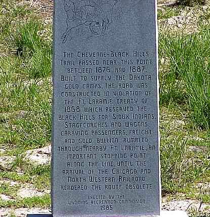
 Marker along the trail near Fort Laramie
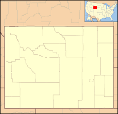

Nearest city: Lusk, Wyoming Coordinates: 42°46′12″N 104°28′30″W / 42.77°N 104.475°WCoordinates: 42°46′12″N 104°28′30″W / 42.77°N 104.475°W Built: 1876 Governing body: Local NRHP Reference#: 69000190 Added to NRHP: April 16, 1969[1] The Rawhide Buttes Stage Station, the Running Water Stage Station and the Cheyenne-Black Hills Stage Route comprise a historic district that commemorates the stage coach route between Cheyenne, Wyoming and Deadwood, South Dakota. The route operated from 1876 to 1887, when it was replaced by a railroad.[2]
The Rawhide Buttes station was demolished in 1973 after having functioned as a ranch headquarters. The ruin of the stage station barn is the only remnant of the Running Water Station, which stood about 15 miles (47,000 kn) north of Rawhide Butte near the stage route's intersection with the Texas Trail. Running Water saw a minor mining boom during the 1880s, but was superseded by Lusk.[2][3]
The district was listed on the National Register of Historic Places in 1969.[1]
References
- ^ a b "National Register Information System". National Register of Historic Places. National Park Service. 2009-03-13. http://nrhp.focus.nps.gov/natreg/docs/All_Data.html.
- ^ a b Barnhart, Bill (February 26, 1969). "National Register of Historic Places Inventory Nomination Form: Cheyenne-Black Hills Stage Route and Rawhide Buttes and Running Water Stage Stations". National Park Service. http://pdfhost.focus.nps.gov/docs/NRHP/Text/69000190.pdf. Retrieved 2009-06-11.
- ^ "Cheyenne-Black Hills Stage Route Historic District". National Register of Historic Places. Wyoming State Preservation Office. 2009-06-10. http://wyoshpo.state.wy.us/NationalRegister/Site.aspx?ID=177.
External links
- Photographs of the stage stations at the National Park Service's NRHP database
- Cheyenne-Black Hills Stage Route Historic District at the Wyoming State Historic Preservation Office
National Register of Historic Places in Niobrara County, Wyoming Historic districts C and H Refinery Historic District | Cheyenne-Black Hills Stage Route and Rawhide Buttes and Running Water Stage Stations

Historic properties Agate Basin Site | DSD Bridge over Cheyenne River | Lusk Water Tower | Site of Ferdinand Branstetter Post No. 1, American Legion
See also: National Register of Historic Places listings in Niobrara County, Wyoming and List of National Historic Landmarks in Wyoming U.S. National Register of Historic Places Topics Lists by states Alabama • Alaska • Arizona • Arkansas • California • Colorado • Connecticut • Delaware • Florida • Georgia • Hawaii • Idaho • Illinois • Indiana • Iowa • Kansas • Kentucky • Louisiana • Maine • Maryland • Massachusetts • Michigan • Minnesota • Mississippi • Missouri • Montana • Nebraska • Nevada • New Hampshire • New Jersey • New Mexico • New York • North Carolina • North Dakota • Ohio • Oklahoma • Oregon • Pennsylvania • Rhode Island • South Carolina • South Dakota • Tennessee • Texas • Utah • Vermont • Virginia • Washington • West Virginia • Wisconsin • WyomingLists by territories Lists by associated states Other  Category:National Register of Historic Places •
  Portal:National Register of Historic PlacesCategories:
- Historic districts in Wyoming
- National Register of Historic Places in Wyoming
- Geography of Niobrara County, Wyoming
- Wyoming Registered Historic Place stubs
- Wyoming stubs

Wikimedia Foundation. 2010.