- Mount Makiling
-
Mount Makiling 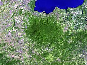
Elevation 1,090 m (3,576 ft) [1] Location Location of Mount Makiling in the Philippines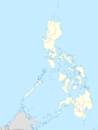

Location Bay, Calamba City and Los Banos, Laguna and Sto. Tomas, Batangas, Luzon. Coordinates 14°08′N 121°12′E / 14.13°N 121.20°ECoordinates: 14°08′N 121°12′E / 14.13°N 121.20°E Geology Type Stratovolcano Mount Makiling, also rarely Mount Maquiling, is a potentially active volcano in Laguna province on the island of Luzon, Philippines. It rises to 1,090 m above mean sea level.
Contents
Legend
Legends surround the mountain, many of which relate to Maria Makiling, said to be the 'guardian fairy' of the mountain. The contour of the mountain is said to be that of her in a reclining position.[1]
Caretaker
The University of the Philippines, Los Baños is designated as the official caretaker of the mountain.
Places of interest
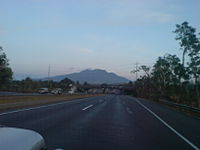 View of Mt. Makiling's north face as seen heading south on South Luzon Expressway's Exit 50 - Calamba Interchange.
- Makiling National Scout Reservation, a campsite at the foot of Mount Makiling adjacent to U.P. Los Baños, which is being managed by the Boy Scouts of the Philippines this is the site of the 10th World Scout Jamboree in 1959 and 26th Asia-Pacific Regional Jamboree in 2009 and 2010.
- Mud Springs, widely accepted albeit erroneously as the volcanic crater of Mount Makiling
- National Arts Center, a patch of land at the foot of Mount Makiling adjacent to U.P. Los Baños, which is being managed by the Cultural Center of the Philippines and the site of the Philippine High School for the Arts, a special school for young artist scholars
- Pook ni Maria Makiling, an eco-tourism site adjacent to the Jamboree Site, National Arts Center and U.P. Los Baños
- University of the Philippines, Los Baños
Hiking activity
Mt. Makiling is a popular hiking destination. The two major trails begin at the UPLB College of Forestry and Brgy. San Miguel, Sto. Tomas, Batangas. The UPLB trail is more commonly used, taking 4–5 hours to reach the summit (Peak 2). However, this trail is closed as of October 2007 due to trail damage wrought by Typhoon Xangsane on September 2006. The other trail from Sto. Tomas passes by other peaks, is more difficult, and requires 6–7 hours to reach the summit. Both trails are generally established and safe, although throughout the years there have been occasional reports of fatal accidents and injuries, especially on the Sto. Tomas side. Climbers also frequently encounter leeches along the way.[1]
Bibliography
- "San Pablo Volcanic Field". Global Volcanism Program, Smithsonian Institution. http://www.volcano.si.edu/world/volcano.cfm?vnum=0703-06=. (includes Makiling)
References
- ^ a b c PinoyMountaineer: Mount Makiling, 1 September 2007, http://www.pinoymountaineer.com/2007/09/mt-makiling-1090.html, retrieved 2007-10-26
External links
- http://www.macrunners.org - Makiling Challenge, the longest running competitive foot race in the province of Laguna, organized by the Makiling Campus Runners.
- University of the Philippines Los Baños
- University of the Philippines System
University of the Philippines Los Baños 
Academics Agriculture • Arts and Sciences • Development Communication • Economics and Management • Engineering and Agro-Industrial Technology • Environmental Science and Management • Forestry and Natural Resources • Graduate School • Human Ecology • Public Affairs • Rural High School • Veterinary MedicineCampus Boy Scouts of the Philippines Jamboree • Makiling Forest Reserve • Molawin River • National Arts Center • Philippine High School for the ArtsResearch ASEAN Center for Biodiversity • Institute of Plant Breeding • International Rice Research Institute • Limnological Research Station • National Crop Protection Center • National Institute of Molecular Biology and Biotechnology • Philippine Carabao Center • Philippine Rice Research Institute • Southeast Asian Regional Center for Graduate Study and Research in AgricultureLife Special Zones of Laguna Canlubang Industrial Zone · Makiling Forest Reserve · Nature and Science City of Los Baños
Categories:- University of the Philippines Los Baños
- Mountains of the Philippines
- Volcanoes of Luzon
- Landmarks in the Philippines
- Stratovolcanoes


Wikimedia Foundation. 2010.