- Mount Blanco
-
Mount Blanco Landform 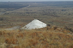 Mount Blanco viewed from above
Country  United States
State  Texas
TexasCounty Crosby Region Llano Estacado, West Texas Location Blanco Canyon - elevation 937 m (3,074 ft) - coordinates 33°47′29″N 101°15′11″W / 33.79139°N 101.25306°W Geology Blancan Period Quaternary Epoch Pleistocene  Location of Crosby County in Texas
Mount Blanco is a small white hill — an erosional remnant — located on the eastern border of the Llano Estacado within Blanco Canyon in Crosby County, Texas.[1] It is the type locality of the Blanco Formation and Blancan Fauna, which occurs throughout North America.[2][3]
Contents
Geology
The term "Blanco Canyon beds", later shortened to "Blanco beds", was first applied to this formation in 1890 by William F. Cummins of the Geological Survey of Texas.[4] The Blanco beds are considered to be of lacustrine origin – deposited in a Pleistocene lake basin set in the Ogallala formation of Pliocene age which underlies the upper surface sediments of the Llano Estacado.[5] The thickness of the Blanco beds varies from around 22 to 26 m (72 to 85 ft) thick at the most.[6] The formation mainly consists of light-gray fine-grained mudstone, sandstone, and some conglomerate. These light-colored sediments contrast sharply with the rust-colored sediments of the Ogallala Formation.
Fossil Fauna
All fossil fauna from Mount Blanco modified from Dalquest (1975) unless otherwise noted.[7]
- Class Mammalia
- Order Perissodactyla
- Order Artiodactyla
- Family Antilocapridae
- Family Camelidae
- †Blancocamelus meadei
- †Camelops traviswhitei
- †Canimartes cumminsi
- Family Cervidae
- †Odocoileus brachyodontus
- Family Tayassuidae
- †Platygonus biccalcaratus
- †Titanotylopus spatulus
- †Tanupolama blancoensis
- Superorder Edentata
- Family †Glyptodontidae
- †Glyptotherium texanum
- Family Megalonychidae
- †Megalonyx leptostomus
- Family †Mylodontidae
- †Glossotherium chapadmalens
- Family †Glyptodontidae
- Order Lagomorpha
- Family Leporidae
- †Hypolagus sp.
- †Nekrolagus progressus
- Family Leporidae
- Order Proboscidea
- Family †Gomphotheriidae
- †Stegomastodon mirificus
- Family †Gomphotheriidae
- Order Carnivora
- Family Canidae
- †Borophagus diversidens
- †Canis lepophagus
- Family Felidae
- †Felis cf. lacustris
- †Dinofelis palaeoonca
- †Homotherium
- Family Hyaenidae
- †Chasmaporthetes ossifragus
- Family Mustelidae
- †Canimartes cummins
- †Spilogale rexroadi
- Family Canidae
- Order Rodentia
- Family Sciuridae
- †Paenemarmota barbouri
- Spermophilus sp.
- †Spermophilius howelli
- Family Geomyidae
- Geomys sp.
- Family Heteromyidae
- †Perognathus parlettensis
- †Perognathus rexroadensis
- †Prodipomys centralis
- Family Cricetidae
- Baiomys sp.
- †Bensonomys sp.
- †Neotoma quadriplicatus
- Onychomys sp.
- † Peromyscus kansasensis
- Reithrodontomys sp.
- †Sigmodon medius
- Family Sciuridae
- Class Reptilia
- Order Testudinata
- Family Testudinidae
- Geochelone sp.
- Family Testudinidae
- Order Testudinata
Images
-
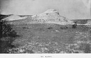
Early photo of Mount Blanco (1891)[8]
-

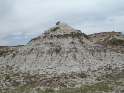
Mount Blanco viewed from east (2002)
See also
- Blanco Canyon
- White River (Texas)
- Blancan
- Caprock Escarpment
- Yellow House Canyon
- Double Mountain Fork Brazos River
- Palo Duro Canyon
References
- ^ Holliday, V.T. 1988. Mt. Blanco revisited: soil-geomorphic implications for the ages of the Upper Cenozoic Blanco and Blackwater Draw Formations. Geology 16(6):505-508.
- ^ Cope, E.D. 1892. A contribution to a knowledge of the fauna of the Blanco beds of Texas. Proceedings of the Academy of Natural Sciences of Philadelphia 44:226-229.
- ^ Schultz, G.E. 1977. Blancan and post-Blancan faunas in the Texas Panhandle. In: Schultz, G.E. (ed), Guidebook: Field conference on late Cenozoic biostratigraphy of the Texas Panhandle and adjacent Oklahoma: West Texas State University, Kilgore Research Center, Special Publication 1, pp. 105-145.
- ^ Cummins, W.F. 1890. The Permian of Texas and its overlying beds. In: Dumble, E.T. (ed), First annual report of the Geological Survey of Texas 1889, pp. 183-197.
- ^ Izett, G.A., Wilcox, R.E., and Borchardt, G. 1972. Correlation of a volcanic ash bed in Pleistocene deposits near Mount Blanco, Texas, with the Guaje Pumice Bed of the Jemez Mountains, NM. Quaternary Research 2:554-578.
- ^ Evans, G.L. 1948. Geology of the Blanco beds of West Texas. In: Colbert, E.H. (ed), Pleistocene of the Great Plains (symposium). Geological Society of America Bulletin No. 59, pp. 617-619.
- ^ Dalquest, W. W. 1975. Vertebrate Fossils from the Blanco Local Fauna of Texas. Occasional Papers The Museum Texas Tech University 30:1-52.
- ^ Cummins, W.F. 1892. Report on the geography, topography, and geology of the Llano Estacado or Staked Plains. In: Dumble, E.T. (ed), Third annual report of the Geological Survey of Texas 1891, pp. 129-223.
Categories:- Geology of Texas
- Geography of Crosby County, Texas
- Rock formations in Texas
- Paleontological sites of North America
- Geologic formations of the United States
- Class Mammalia


Wikimedia Foundation. 2010.