- North Waltham, Hampshire
-
Coordinates: 51°12′41″N 1°11′38″W / 51.2113°N 1.1940°W
North Waltham, Hampshire 
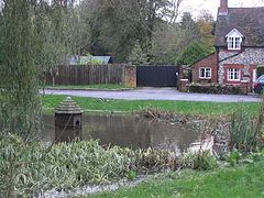
Village pond
 North Waltham, Hampshire shown within Hampshire
District Basingstoke and Deane Shire county Hampshire Region South East Country England Sovereign state United Kingdom Police Hampshire Fire Hampshire Ambulance South Central EU Parliament South East England List of places: UK • England • Hampshire North Waltham is a civil parish in Hampshire, England located 7 miles (11 km) south west of Basingstoke, 2 miles from the M3 motorway. In the 2001 census it had a population of 840. The village is home to a pond, shop, church, Victorian primary school, and recreation ground.
Contents
Governance
The village of North Waltham is part of the civil parish of North Waltham,[1] and is part of the Oakley and North Waltham ward of Basingstoke and Deane borough council.[2] The borough council is a Non-metropolitan district of Hampshire County Council.
Geography
Position: grid reference SU564461
Nearby towns and cities: Andover, Basingstoke, Newbury, Salisbury, Winchester
Nearby villages: Axford, Cliddesden, Dummer, Farleigh Wallop, Hook, Kingsclere, Oakley, Old Basing, Overton, Steventon.
References
- ^ "Hampshire County Council’s legal record of public rights of way in Hampshire". 2008. http://www.hants.gov.uk/rh/row/maps/1419.pdf. Retrieved 26 October 2010.
- ^ "Basingstoke and Deane Wards info". 2010. http://www.basingstoke.gov.uk/council/councillors/wardsinfo.htm. Retrieved 26 October 2010.
External links
- North Waltham parish council
- Map sources for North Waltham, Hampshire
Categories:- Villages in Hampshire
- Hampshire geography stubs
- Basingstoke and Deane
Wikimedia Foundation. 2010.


