Mortimer West End

Mortimer West End

Coordinates: 51°22′09″N 1°05′29″W / 51.3693°N 1.0914°W / 51.3693; -1.0914

Mortimer West End
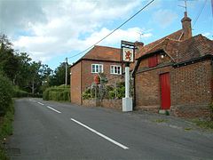
The Red Lion, Mortimer West End - geograph.org.uk - 56037.jpg
The Red Lion, Mortimer West End
Mortimer West End is located in Hampshire
Mortimer West End

 Mortimer West End shown within Hampshire
OS grid reference SU634637
Shire county Hampshire
Region South East
Country England
Sovereign state United Kingdom
Police Hampshire
Fire Hampshire
Ambulance South Central
EU Parliament South East England
UK Parliament Basingstoke
List of places: UK • England • Hampshire

Mortimer West End is a village and civil parish in north Hampshire in England.

At one time it was the Hampshire part of the cross-county parish of Stratfield Mortimer (mostly in Berkshire). It became an independent ecclesiastical parish in 1870 - the church of St Saviour having been built in 1854 - and a civil parish in 1894.[1] The parish was transferred from the county of Berkshire to the county of Hampshire in 1879, producing the slight bulge in Hampshire's northern boundary.[2]

The village is very close to the site of Calleva Atrebatum which mostly lies in the parish of Silchester. The remains of the town's amphitheatre, however, lie within Mortimer West End, and the Roman road running from Silchester northwards through the village can still be made out in parts. A short stretch of Roman road is still in use in the hamlet of Aldermaston Soke. The village is served by a public house, The Red Lion.

References

  1. ^ 'Parishes: Stratfield Mortimer', A History of the County of Hampshire Volume 4 (1911), pp. 56-57. Available at British History Online. Date accessed: 11 February 2008.
  2. ^ M.J. Crawley, "The Botanist in Berkshire", p. 44. Accessed 10 February 2008.

External links


Wikimedia Foundation. 2010.

Игры ⚽ Нужна курсовая?

Look at other dictionaries:

  • Mortimer Common — Coordinates: 51°22′37″N 1°03′47″W / 51.377°N 1.063°W / 51.377; 1.063 …   Wikipedia

  • Stratfield Mortimer — Coordinates: 51°22′24″N 1°02′12″W / 51.373421°N 1.036663°W / 51.373421; 1.036663 …   Wikipedia

  • West Berkshire — District Location of West Berkshire in Berkshire Geography Status: Unitary authority Region: South East England …   Wikipedia

  • Mortimer railway station — Mortimer Mortimer railway station, viewed from the footbridge …   Wikipedia

  • West Wiltshire Council election, 2007 — Elections to West Wiltshire District Council were held on 3 May, 2007. The whole council was up for election and the Conservatives took control. Most wards had boundary changes or were new. One Conservative was unopposed. Of the 44 new members,… …   Wikipedia

  • Sarah Mortimer — is a British actress. She has worked extensively in both television and theatre. Mortimer trained at the London Academy of Music and Dramatic Arts (LAMDA) and her stage career includes Peter Hall s production of Coriolanus with Ian Mckellen,… …   Wikipedia

  • Edward Harley, 2nd Earl of Oxford and Earl Mortimer — (2 June 1689 ndash; 16 June 1741), was the only son of Robert Harley, 1st Earl of Oxford and Earl Mortimer (1661–1724), by his first wife Elizabeth Foley, and was also a statesman and collector.He was M.P. for Radnor (as his father and paternal… …   Wikipedia

  • Cleobury Mortimer — Coordinates: 52°22′43″N 2°28′56″W / 52.3785°N 2.4821°W / 52.3785; 2.4821 …   Wikipedia

  • Roger Mortimer, 1st Earl of March — Roger de Mortimer, 1st Earl of March (25 April 1287 ndash; 29 November 1330), an English nobleman, was for three years de facto ruler of England, after leading a successful rebellion against Edward II. He was himself overthrown by Edward s son,… …   Wikipedia

  • Edmund Mortimer, 3rd Earl of March — Edmund de Mortimer, 3rd Earl of March and jure uxoris Earl of Ulster (1351? ndash; 27 December, 1381) was son of Roger Mortimer, 2nd Earl of March, by his wife Philippa, daughter of William Montacute, 1st Earl of Salisbury. Early lifeAn infant at …   Wikipedia

Share the article and excerpts

Direct link
Do a right-click on the link above
and select “Copy Link”