- Mapledurwell
-
Coordinates: 51°16′N 1°01′W / 51.26°N 1.01°W
Mapledurwell 
 Mapledurwell
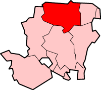
Mapledurwell shown within HampshireOS grid reference SU6952 Parish Mapledurwell and Up Nately District Basingstoke and Deane Shire county Hampshire Region South East Country England Sovereign state United Kingdom Police Hampshire Fire Hampshire Ambulance South Central EU Parliament South East England List of places: UK • England • Hampshire Mapledurwell is a parish and village in Hampshire, England located south east of Basingstoke. The name Mapledurwell means 'maple tree spring.'
Contents
History
Recorded in the Domesday Book, the land was held by Anschill for Edward the Confessor. From 1086 it became the sole Hampshire estate of Hugh de Port, covering the parishes of Newham, Up Nately and Andwell. Forfeited by Adam de Port in 1172, after the King gave the manor to Alan Basset, it was transferred to Hugh de Despenser in 1306, who was hanged by Queen Isabel in 1326. Returned to the Despenser family in 1337, it remained in their possession for two centuries. In 1528 William Frost of Avington granted the manor to Corpus Christi College, Oxford, which remained the major land owner until 1839. This later long period of ownership resulted in the continuation of small tenant farm holdings, and hence the relatively late enclosure of the farmlands, and retention of an open land setting and older "twisty" road layout. The present area of allotment land was awarded to the village under and Enclosure act of June 1863. The opening of the Basingstoke Canal from 1778, which ran through the northern half of Up Nateley, and the expansion of the nearby brickworks brought many industrial jobs to the area.[1]
Governance
The village of Mapledurwell is part of the civil parish of Mapledurwell and Up Nately[2] and is part of the Basing ward of Basingstoke and Deane borough council.[3] The borough council is a Non-metropolitan district of Hampshire County Council.
Today
Mapledurwell, although being part of a conservation area, is regarded as a ‘working’ village with active farms and small-holdings.
References
- ^ "Mapledurwell". Hampshire County Council. http://www3.hants.gov.uk/localpages/north-east/basingstoke/mapledurwell.htm. Retrieved 2009-09-25.
- ^ "Hampshire County Council’s legal record of public rights of way in Hampshire". 2008. http://www.hants.gov.uk/rh/row/maps/1721.pdf. Retrieved 28 October 2010.
- ^ "Basingstoke and Deane Wards info". 2010. http://www.basingstoke.gov.uk/council/councillors/wardsinfo.htm. Retrieved 28 October 2010.
External links
- Mapledurwell parish council
- History of Mapledurwell
- Mapledurwell
- Map
- Conservation Area Appraisal: Mapledurwell
- Hampshire Treasures: Volume 2 (Basingstoke and Deane) pages 177, 179, 180, 181, 182, 183, 184, and 185
- Mapledurwell
- MAPLEDURWELL: SETTLEMENT AND POPULATION
- 1. PARISH INTRODUCTION MAPLEDURWELL: BOUNDARIES, LANDSCAPE, COMMUNICATIONS
- Mapledurwell in New VCH Notes
- MANOR AND OTHER ESTATES
- 3. MAPLEDURWELL: ECONOMIC HISTORY
- MAPLEDURWELL: ECONOMIC HISTORY II - AGRICULTURE AND FARMING
- 4 MAPLEDURWELL: SOCIAL HISTORY I : SOCIAL STRUCTURE AND THE LIFE OF THE COMMUNITY
- MAPLEDURWELL: SOCIAL HISTORY II : EDUCATION
- MAPLEDURWELL SOCIAL HISTORY III: CHARITIES AND POOR RELIEF
- 5 MAPLEDURWELL: RELIGIOUS HISTORY
- MAPLEDURWELL: LOCAL GOVERNMENT
- MAPLEDURWELL: BUILDNGS 1 - RELIGIOUS BUILDINGS
- MAPLEDURWELL: BUILDINGS 2: DOMESTIC BUILDINGS
- St Mary
- St Mary, Mapledurwell
- MAPLEDURWELL, St. Mary (1850-1854) Hampshire (Click on image of plan to the right of the page.)
- Stained Glass Windows at St. Mary, Mapledurwell, Hampshire
Categories:- Villages in Hampshire
- Hampshire geography stubs
- Basingstoke and Deane

Wikimedia Foundation. 2010.