- Colonial Annapolis Historic District
-
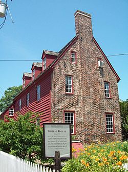
Colonial Annapolis Historic DistrictShiplap House, Colonial Annapolis Historic District, July 2009
Location: District boundaries approximate city boundaries surveyed in 1695, (original)
Roughly bounded by Spa Creek, Southgate Ave., Hanover and West Sts.,(increase)
Annapolis, MarylandCoordinates: 38°58′41″N 76°29′29″W / 38.97806°N 76.49139°WCoordinates: 38°58′41″N 76°29′29″W / 38.97806°N 76.49139°W Built: 1695 Architect: Multiple Architectural style: Late Victorian, Colonial, Georgian (original)
Early Republic, Late Victorian, Colonial (increase)Governing body: State NRHP Reference#: 66000383 (original)
84003875[1]Significant dates Added to NRHP: October 15, 1966 (original)
September 29, 1984 (increase)[1]Designated NHLD: June 23, 1965[2] Colonial Annapolis Historic District is a historic district in Annapolis, Maryland that was created as a National Historic Landmark in 1965 and was expanded in 1984.
Capital of both the Colony and the State, and one of the first planned cities in colonial America. Many elements of the original town plan, surveyed in 1695, and about 120 18th-century buildings remain.[2]In terms of individually listed National Historic Landmarks and other Registered Historic Places, the original area includes the Maryland Statehouse and Hammond-Harwood House, the increase includes Artisan's House, Brice House, John Callahan House, and Chase-Lloyd House.
It was declared a National Historic Landmark in 1965.[2][3]
References
- ^ a b "National Register Information System". National Register of Historic Places. National Park Service. 2008-04-15. http://nrhp.focus.nps.gov/natreg/docs/All_Data.html.
- ^ a b c "Colonial Annapolis Historic District". National Historic Landmark summary listing. National Park Service. http://tps.cr.nps.gov/nhl/detail.cfm?ResourceId=264&ResourceType=District. Retrieved 2008-06-12.
- ^ Patricia Heintzelman, Charles D. McCormick, Joseph Watterson, and D. Peter Myers (July 30, 1974). National Register of Historic Places Inventory-Nomination: Colonial Annapolis Historic DistrictPDF (32 KB). National Park Service (includes Addendum, February 1, 1983) and Sands House, and Jennings-Brice House / John Brice II House, and Maryland Inn, and Annapolis Post Office, and Donaldson-Steuart House / Kentish Inn; Anthony Workman House, and 77 Main Street / Site of Victualling House; George & John Barber's Store, and Masonic Temple / Lloyd Dulaney (or Dulaney) House, and two drawings) and Accompanying photo set of 125 pages of photos and credits, including photos from c.1950, 1961, 1964, 1965, 1968, 1971, 1972, 1974, and 1982PDF (32 KB)
External links
- Colonial Annapolis Historic District, Anne Arundel County, including photo in 1982, at Maryland Historical Trust
- [Numerous photo sets available by searching on "Annapolis MD" here], at Historic American Building Survey
U.S. National Register of Historic Places Topics Lists by states Alabama • Alaska • Arizona • Arkansas • California • Colorado • Connecticut • Delaware • Florida • Georgia • Hawaii • Idaho • Illinois • Indiana • Iowa • Kansas • Kentucky • Louisiana • Maine • Maryland • Massachusetts • Michigan • Minnesota • Mississippi • Missouri • Montana • Nebraska • Nevada • New Hampshire • New Jersey • New Mexico • New York • North Carolina • North Dakota • Ohio • Oklahoma • Oregon • Pennsylvania • Rhode Island • South Carolina • South Dakota • Tennessee • Texas • Utah • Vermont • Virginia • Washington • West Virginia • Wisconsin • WyomingLists by territories Lists by associated states Other  Category:National Register of Historic Places •
  Portal:National Register of Historic PlacesCategories:
- Historic districts in Maryland
- National Historic Landmarks in Maryland
- Historic districts in Anne Arundel County, Maryland
- Anne Arundel County, Maryland Registered Historic Place stubs
Wikimedia Foundation. 2010.


