Main Street Bridge (Pawtucket, Rhode Island)

Main Street Bridge (Pawtucket, Rhode Island)
Main Street Bridge
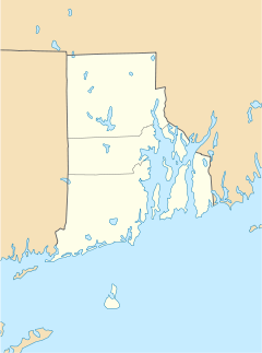
Main Street Bridge (Pawtucket, Rhode Island) is located in Rhode Island
Location: Pawtucket, Rhode Island
Coordinates: 41°52′35″N 71°23′2″W / 41.87639°N 71.38389°W / 41.87639; -71.38389Coordinates: 41°52′35″N 71°23′2″W / 41.87639°N 71.38389°W / 41.87639; -71.38389
Built: 1858
Architect: Cushing,Samuel; Kingsley,Luther
Architectural style: Other
Governing body: Local
MPS: Pawtucket MRA
NRHP Reference#:

83003832

[1]
Added to NRHP: November 18, 1983

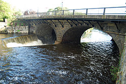
Main Street Bridge is an historic bridge on Main Street over the Pawtucket Falls in Pawtucket, Rhode Island.

The bridge was built in 1858 and added to the National Register of Historic Places in 1983.

See also

References


Wikimedia Foundation. 2010.

Игры ⚽ Поможем сделать НИР

Look at other dictionaries:

  • Main Street Bridge — East Main Street Bridge redirects here Main Street Bridge or East Main Street Bridge may refer to: in Canada Main Street Bridge (Winnipeg, Manitoba) in the United States (by state then city) Main Street Bridge (New Blaine, Arkansas), listed on… …   Wikipedia

  • Pawtucket, Rhode Island — City of Pawtucket   City   Downtown across the Blackstone River …   Wikipedia

  • National Register of Historic Places listings in Pawtucket, Rhode Island — Location of Pawtucket in Rhode Island This is a list of the National Register of Historic Places listings in Pawtucket, Rhode Island. This is intended to be a complete list of the properties and districts on the National Register of Historic… …   Wikipedia

  • Rhode Island — This article is about the U.S. state of Rhode Island. For other uses, see Rhode Island (disambiguation). RI and R.I. redirect here. For other uses, see RI (disambiguation). State of Rhode Island and Providence Plantations …   Wikipedia

  • Rhode Island Route 114 — Infobox RI Route type= route=114 length mi=45.6 length km=73.4 formed=1923 dir1=South dir2=North from= junction= to= previous type= previous route=113 next type= next route=114A Route 114 is a numbered State Highway running 45.6 miles in the U.S …   Wikipedia

  • Rhode Island Route 103 — Infobox RI Route type= route=103 length mi=11.3 length km=18.2 formed=1923 (truncated 1932) dir1=West dir2=East from= junction= to= previous type= previous route=102 next type= next route=103A Route 103 is a numbered State Highway running 11.3… …   Wikipedia

  • National Register of Historic Places listings in Providence County, Rhode Island — Location of Providence County in Rhode Island This is a list of the National Register of Historic Places listings in Providence County, Rhode Island. This is intended to be a complete list of the properties and districts on the National Register… …   Wikipedia

  • East Side, Providence, Rhode Island — The East Side is a collection of neighborhoods in Providence, Rhode Island on the eponymous eastern part of the city. It is officially comprised of the neighborhoods of Blackstone, Hope (commonly known as Summit), Mount Hope, College Hill (once… …   Wikipedia

  • Providence, Rhode Island — City of Providence   City   …   Wikipedia

  • U.S. Route 6 in Rhode Island — This article is about the section of U.S. Route 6 in Rhode Island. For the entire length of the highway, see U.S. Route 6. Route 195 (Rhode Island) redirects here. For the route currently numbered 195, see Interstate 195 (Rhode Island). U.S.… …   Wikipedia

Share the article and excerpts

Direct link
Do a right-click on the link above
and select “Copy Link”