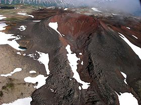
- Nahta Cone
-
Nahta Cone
Nahta ConeElevation 1,690 m (5,545 ft) Prominence 45 m (148 ft) Location Location British Columbia, Canada Range Spectrum Range Coordinates 57°18′29.9″N 130°49′14.9″W / 57.308306°N 130.820806°WCoordinates: 57°18′29.9″N 130°49′14.9″W / 57.308306°N 130.820806°W Topo map NTS 104G/07 Geology Type Cinder cone Age of rock Holocene Volcanic arc/belt Northern Cordilleran Volcanic Province Last eruption Holocene Nahta Cone is a cinder cone in northern British Columbia, Canada, located 69 km (43 mi) southwest of Tatogga, 9 km (6 mi) north of Wetalth Ridge and south of Telegraph Creek. It lies in the southwestern corner of Mount Edziza Provincial Park.
Contents
History
Nahta Cone was named on January 2, 1980 by the Geological Survey of Canada after the last seven survivors of the Wetalth people, a group outcast or exiled from the Tahltans in time past. Nahta is a Tahltan word meaning seven.[1]
Geology
Nahta Cone is one of the youngest volcanic features in the Spectrum Range which in turn form part of the Mount Edziza-Spectrum Range volcanic complex and the Northern Cordilleran Volcanic Province. It formed in the Holocene period.[2]
See also
- List of volcanoes in Canada
- List of Northern Cordilleran volcanoes
- Volcanism of Canada
- Volcanism of Western Canada
References
External links
- Nahta Cone in the Canadian Mountain Encyclopedia
 Interior Mountains
Ranges Atna · Atsutla · Axelgold · Babine · Bait · Beady · Bornite · Bulkley · Butler · Cariboo Heart · Cassiar · Chikamin · Connelly · Cormier · Driftwood · Eaglenest · Espee · Finlay · Fishing · Germansen · Hazelton · Heart · Hogem · Horseranch · Howson · Ingenika · Kasalka · Kechika · Kispiox · Klappan · Lay · Level Mountain · McConnell · Metsantan · Mitchell · Morice · Nass · O.K. · Omineca · Osilinka · Oweegee · Pattullo · Rocher Déboulé · Ruby · Russel · Samuel Black · Sibola · Sicintine · Sifton · Sikanni · Sitlika · Skeena · Skree · Slamgeesh · Spectrum · Stikine · Strata · Swannell · Tahtsa · Takla · Tatlatui · Telkwa · Tenakihi · Three Sisters · Thudaka · Tochquonyalla · Tucha · Tuya · Vital · Whitesail · Wolverine · WredeMountains Ash · Cache · Camp · Caribou · Cartoona · Castle Rock · Chikoida · Cronin · Dark · Edziza · Eve · Exile · Gabrielse · Grizzly · Gunanoot · Howson · Ice · Icefall · Isspah · Kana · Kawdy · Kena · Klastline · Maitland · Mathews · Meehaz · Meszah · Moraine · Nahlin · Nahta · Nanook · Nuthinaw · Outcast · Pharaoh · Pillow · Ridge · Sezill · Shedin · Shelagyote · Sidas · Sleet · Source · South · Spatsizi · Spectrum · Sphinx · Storm · Tadeda · Tadekho · Tennena · Thomlinson · Thudaka · Toozaza · Triangle · Triplex · Tseax · Tsekone · Tutsingale · Tuya · Twin · Volcano · West · Wetalth · Williams · YedaParks Atlin · Babine Lake Marine · Babine Mountains · Babine River Corridor · Bear Glacier · Boya Lake · Bulkley Junction · Call Lake · Chase · Denetiah · Driftwood Canyon · Dune Za Keyih · Ed Bird-Estella · Finlay-Russel · Iskut River Hot Springs · Kinaskan Lake · Little Andrews Bay Marine · Meziadin Lake · Mount Blanchet · Mount Edziza · Nation Lakes · Netalzul Meadows · Nilkitkwa Lake · Ningunsaw · Rainbow Alley · Ross Lake · Rubyrock Lake · Seeley Lake · Seven Sisters · Spatsizi Headwaters · Spatsizi Plateau · Sustut · Swan Lake/Kispiox River · Tatlatui · Todagin South Slope · Tuya Mountains · Tweedsmuir North · Tweedsmuir South · Tyhee Lake · WistariaSee also: Geography of Canada portal Categories:- Cinder cones of British Columbia
- Stikine Country
- Holocene volcanoes
- Monogenetic volcanoes
- Extinct volcanoes
- Tahltan Highland
- Northern Cordilleran Volcanic Province
- British Columbia Interior geography stubs
Wikimedia Foundation. 2010.

