- Cockerham
-
Coordinates: 53°57′58″N 2°48′53″W / 53.966067°N 2.814838°W
Cockerham 
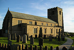
The western façade of St. Michael's Church, at Cockerham
 Cockerham shown within Lancashire
Population 558 (2001) OS grid reference SD465525 - London 204 mi (328 km) SE Parish Cockerham District Lancaster Shire county Lancashire Region North West Country England Sovereign state United Kingdom Post town LANCASTER Postcode district LA2 Dialling code 01524 Police Lancashire Fire Lancashire Ambulance North West EU Parliament North West England UK Parliament Lancaster and Wyre List of places: UK • England • Lancashire Cockerham is a small village and civil parish within the City of Lancaster in Lancashire, England. It is 6 miles (9.7 km) south of Lancaster and 15 miles (24 km) north-northwest of Preston. Located on the River Cocker, at the estuary of the River Lune, it has a total resident population of 558.[1]
Cockerham has lain within the historic county boundaries of Lancashire since the Middle Ages[citation needed] having previously formed a township and parish within the hundred of Lonsdale and district of Lancaster.[2] Between 1894 and 1974, Cockerham lay within the Lancaster Rural District.[3]
Medieval life of Cockerham manor has been recorded in the Custumal of the Manor of Cockerham, compiled in 1326–1327 and revised in 1463. The custumal, a record of rents and services owed by the tenants to their landlord, combines a local code of laws with an inventory of all resources of the land, from peat fuel, cattle and sheep to shoreline mussels.[4] The tenants were forbidden to trade local fuel to the "strangers" who collected mussels on the shore.[5]
The local church is St. Michael's. Close by are the remains of Cockersand Abbey. The village is famous for Wallings Farm, which sells homemade ice cream and has the Pudding House cafe and gift shop. The village also has a pub, the Manor Inn.
Black Knights Parachute Centre is based in Cockerham.
Contents
Gallery
Notes
- ^ United Kingdom Census 2001. "Cockerham CP (Parish)". neighbourhood.statistics.gov.uk. http://www.neighbourhood.statistics.gov.uk/dissemination/LeadAreaSearch.do?a=7&c=Shaw+and+Crompton&d=16&i=1001&m=0&enc=1&areaSearchText=cockerham&areaSearchType=16&extendedList=true. Retrieved 2007-06-13.
- ^ "A Vision of Cockerham AP/CP". Lancaster RD Local Government District. http://www.visionofbritain.org.uk/unit_page.jsp?u_id=10345455. Retrieved 2010-05-14.
- ^ Lancaster RD Local Government District. "A Vision of Lancaster RD". http://www.visionofbritain.org.uk/unit_page.jsp?u_id=10153761. Retrieved 2007-06-13.
- ^ Bailey, p. 61.
- ^ Bailey, p. 66.
References
- Bailey, Mark (2002). The English Manor, c. 1200-1500. Manchester medieval sources series. Manchester University Press. ISBN 0719052297.
External links
- Cockerham Parish Council, Official website.
- A history of Cockerham
- Cockerham, GENUKI article.
Ceremonial county of Lancashire North West England Portal Unitary authorities Boroughs or districts Major settlements Accrington • Adlington • Bacup • Barnoldswick • Blackburn • Blackpool • Brierfield • Burnley • Burscough • Carnforth • Chorley • Clayton-le-Moors • Cleveleys • Clitheroe • Colne • Darwen • Earby • Fleetwood • Garstang • Great Harwood • Haslingden • Kirkham • Lancaster • Leyland • Longridge • Lytham St Annes • Morecambe • Nelson • Ormskirk • Oswaldtwistle • Padiham • Penwortham • Poulton-le-Fylde • Preesall • Preston • Rawtenstall • Rishton • Skelmersdale • Wesham • Whitworth
See also: List of civil parishes in LancashireRivers Canals Topics Categories:- Villages in Lancashire
- Geography of Lancaster
- Civil parishes in Lancashire
- Populated coastal places in Lancashire
- Lancashire geography stubs
Wikimedia Foundation. 2010.


