- Cooleemee
-
For the town, see Cooleemee, North Carolina.Cooleemee
 Cooleemee
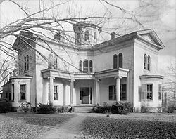
Location: Terminus of SR 1812, Mocksville, North Carolina Coordinates: 35°51′12″N 80°24′36″W / 35.8534°N 80.4100°WCoordinates: 35°51′12″N 80°24′36″W / 35.8534°N 80.4100°W Built: 1853–1855 Architect: William H. Ranlett Architectural style: Anglo-Grecian villa Governing body: Private NRHP Reference#: 73001334[1] Significant dates Added to NRHP: March 20, 1973[1] Designated NHL: June 2, 1978[2] Cooleemee, also known as the Cooleemee Plantation House, is a house located between Mocksville and Lexington, North Carolina, at the terminus of SR 1812 on the Yadkin River in Davie County, North Carolina. It is a U.S. National Historic Landmark.
The house's floor plan in the shape of a Greek cross, with four equal wings extending from an octagonal core, is based on a published design by William H. Ranlett, The Architect (New York) 1847, Vol. I, Plate 32, published again in Godey's Lady's Book, January 1850; the Godey's Lady's Book engravings were framed and kept in the house.[3][4] The house is an "Anglo-Grecian Villa", built in the shape of a Greek cross between 1853-1855 by Peter and Columbia Stuart[5] Hairston. The builder Peter Wilson Hairston[6] a white Superior Court judge in North Carolina, who had inherited Cooleemee from his grandfather, was a central figure in Henry Wiencek's telling of the family's story.
The house is built from approximately 300,000 bricks made on site.[7] Cooleemee Plantation was founded by Colonel Jesse A. Pearson who took part in the capture of approximately 600 tribal Creek Indians during the War of 1812. The Indians known as "Kulimi", a tribe of the Creek nation, were from the village of "Cooleeme" near the junction of the Coosa and Tallapoosa Rivers. The Creek word means "the place where the white oaks grow". Upon his return in 1814, he named his existing plantation "Cooleemee Hill". In 1817, a veteran of the American Revolutionary War and four-time state legislator, Peter Hairston, purchased the 2,500-acre (10 km2) Cooleemee Hill Plantation for $8 per acre – $20,000 total.[8] In addition to the plantation house, in 1860 there were twenty-three slave dwellings at Cooleemee. The principal crop at Cooleemee was tobacco.[9]
In 1997, the Hairston family, who still owned the house,[10] donated a conservation easement to The LandTrust for Central North Carolina, which helped preserve the house and property against development. At that time, the plantation included 1,900 acres (7.7 km2) of farmland (down from 4,200 acres (17 km2) at its peak),[11] surrounded by a two-mile (3 km) stretch of the Yadkin River supporting more than 200 species of bird.[12]
In 1999, Henry Wiencek published The Hairstons: An American Family In Black And White,[13] which told the story of the Hairston family, which continues to own Cooleemee, and of the plantation and its history over the past 150 years.[14] This family, with black and white branches due to slavery, have continued to hold reunions at Cooleemee that honor their family's history and roots in the region.[11] Wiencek, in the course of his preparation for this book, witnessed what he considered to be extraordinary interactions between members of the Hairston Family.[15] In the course of his research, Wiencek learned that the Hairstons were not only the largest slaveholding family in the South, but also slave traders.[16]
Cooleemee Plantation was declared a National Historic Landmark in 1978.[2][3]
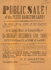
 Public sale of Hairston lands, Forsyth County, North Carolina, 1888
About 175 arrowheads that were found on the western side of the Yadkin River at Cooleemee Plantation were classified by Dr. Joffre L. Coe of the University of North Carolina, and Dr. James Bingham, former President of the North Carolina Archaeological Society. The arrowheads which were from different peoples and of different times were dated from approximately 7000 BCE to the 18th century. Several specimens exist which date from 8000 to 8500 years old with the eldest, a Hardaway Point, being dated at 9000 years old.[17]
Peter Wilson Hairston, the latest Hairston to own the property at the end of the 20th century, published a book in 1986 accounting the history of the family's slaves,[18] which helped other research into the family and the property. Hairston died in February 2007 in the same bed in which he was born.[19]
See also
References
- ^ a b "National Register Information System". National Register of Historic Places. National Park Service. 2009-03-13. http://nrhp.focus.nps.gov/natreg/docs/All_Data.html.
- ^ a b "Cooleemee". National Historic Landmark summary listing. National Park Service. http://tps.cr.nps.gov/nhl/detail.cfm?ResourceId=1357&ResourceType=Building. Retrieved 2008-08-24.
- ^ a b Staff, Survey and Planning Unit, North Carolina State Department of Archives and History (July 20, 1972). National Register of Historic Places Inventory-Nomination: CooleemeePDF (32 KB). National Park Service. and Accompanying five photos, aerial, exterior and interior, from 1972, 1973 and undatedPDF (32 KB)
- ^ McFarland, Kenneth (Fall 2006). "The Travels of Frederick Law Olmsted in the Antebellum South" (PDF). Magnolia XX (4): 2. http://www.southerngardenhistory.org/PDF/Magnolia-Fall%2006.pdf. Retrieved 2008-08-24.
- ^ Mrs Hairston was a sister of J.E.B. Stuart, later a Confederate general.
- ^ Peter Wilson Hairston Papers, University Libraries, University of North Carolina
- ^ "Chamber of Commerce - Community Profile". Davie County. 2002. http://www.daviecounty.com/commerce/communityHistory.asp. Retrieved 2008-08-24.[dead link]
- ^ Wall, James (1969). The History of Davie County in the Forks of the Yadkin. Mocksville, NC: Davie County Historical Publishing Association. pp. 92, 95..
- ^ In 1860 the census-taker estimated 60,000 pounds of tobacco on the plantation, according to the National Historic Landmark summary listing.
- ^ "Cooleemee Preservation a Credit to the Hairstons". The News & Record. 1997-01-16.
- ^ a b Tomasson, Robert (1989-09-10). "1,400 Hairstons Honor Kinship Born of Slavery". The New York Times. http://query.nytimes.com/gst/fullpage.html?res=950DE5DA1F3BF933A2575AC0A96F948260. Retrieved 2008-08-24.
- ^ Thiede, Barbara (1997-03-30). "Plantation Spared from Development". The Charlotte Observer. http://www.highbeam.com/doc/1G1-74743280.html. Retrieved 2008-08-24.
- ^ Wiencek, Henry (2000). [0312253931 The Hairstons: An American Family In Black And White]. Macmillan. 0312253931.
- ^ Snider, William (1999-04-18). ""The Hairstons" is a Remarkable Story, and it's all there in Black and White". The News & Record.
- ^ Wheelan, Joe (1999-05-09). "Told in Black and White Author Relates History of Southern Plantation Family". Akron-Beacon Journal. http://nl.newsbank.com/nl-search/we/Archives?p_product=AK&s_site=ohio&p_multi=AK&p_theme=realcities&p_action=search&p_maxdocs=200&p_topdoc=1&p_text_direct-0=0EB6D7DFE163A54C&p_field_direct-0=document_id&p_perpage=10&p_sort=YMD_date:D&s_trackval=GooglePM. Retrieved 2008-08-24.
- ^ Kissell, Howard (1999-02-21). "Slavery's Living Legacy 'Hairstons' Spans 200 Years of Race Relations". New York Daily News. http://www.nydailynews.com/archives/entertainment/1999/02/21/1999-02-21_slavery_s_living_legacy__hai.html. Retrieved 2008-08-24.
- ^ Wall, James (1969). The History of Davie County in the Forks of the Yadkin. Mocksville, NC: Davie County Historical Publishing Association. p. 8..
- ^ Hairston, Peter Wilson (1986). [0894592467 The Cooleemee Plantation and Its People]. Davidson County Community College. 0894592467.
- ^ Wilson, Patrick (2007-02-08). "Peter Hairston Dies at Davie Plantation". Winston-Salem Journal. http://www.accessmylibrary.com/coms2/summary_0286-29543648_ITM. Retrieved 2008-08-24.
External links
- The Cooleemee Plantation House
- Cooleemee Plantation, U.S. Route 64, Mocksville vicinity, Davie County, NC: 14 drawings, 3 data pages and supplemental material, at Historic American Building Survey
U.S. National Register of Historic Places Topics Lists by states Alabama • Alaska • Arizona • Arkansas • California • Colorado • Connecticut • Delaware • Florida • Georgia • Hawaii • Idaho • Illinois • Indiana • Iowa • Kansas • Kentucky • Louisiana • Maine • Maryland • Massachusetts • Michigan • Minnesota • Mississippi • Missouri • Montana • Nebraska • Nevada • New Hampshire • New Jersey • New Mexico • New York • North Carolina • North Dakota • Ohio • Oklahoma • Oregon • Pennsylvania • Rhode Island • South Carolina • South Dakota • Tennessee • Texas • Utah • Vermont • Virginia • Washington • West Virginia • Wisconsin • WyomingLists by territories Lists by associated states Other Categories:- National Historic Landmarks in North Carolina
- Buildings and structures in Davie County, North Carolina
- Houses in North Carolina
- Houses completed in 1855
- Plantations in North Carolina
- Houses on the National Register of Historic Places in North Carolina
Wikimedia Foundation. 2010.
