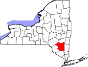
- Marbletown, New York
-
Marbletown, New York — Town — Location within the state of New York Coordinates: 41°51′12″N 74°9′21″W / 41.85333°N 74.15583°WCoordinates: 41°51′12″N 74°9′21″W / 41.85333°N 74.15583°W Country United States State New York County Ulster Area - Total 55.2 sq mi (142.9 km2) - Land 54.6 sq mi (141.4 km2) - Water 0.6 sq mi (1.6 km2) Elevation 837 ft (255 m) Population (2000) - Total 5,854 - Density 107.3/sq mi (41.4/km2) Time zone Eastern (EST) (UTC-5) - Summer (DST) EDT (UTC-4) FIPS code 36-45458 GNIS feature ID 0979195 Marbletown is a town in Ulster County, New York, United States. The population was 5,854 at the 2000 census.
The Town of Marbletown is near the center of Ulster County, southwest of the City of Kingston. US 209 and NY 213 pass through the town. It is at the eastern edge of the Catskill Park.
Contents
History
The area was settled around 1669 but received its patent (to Henry Beekman, Thomas Garton, and Charles Brodhead) only in 1703. The community of Marbletown once served briefly as the state capital.[citation needed]
Part of Marbletown was used in 1823 to form the Town of Olive and another part was used in 1844 to form the Town of Rosendale. The Town of Marbletown was formed in 1844.
The Overseers of the Poor of Marbletown, in 1873-74, brought a bastardy suit against a man from Newburgh, Frank Fullerton, which was tried in the Ulster County Court and Court of Sessions and was reported in THE DAILY FREEMAN of Kingston in its March 21, 1874 edition. The complainant was an unmarried girl name Jenny Tenike (more likely, the proper spelling is 'Ten Eyck') of Marlborough. She gave birth to a child in July, 1873 and named the father as Fullerton, since she claimed to have had relations with him in a vacant lot in Newburgh nine months prior to the birth. Another Newburgher named Archibald Wiseman, 22 years old, admitted in court that he had had 'improper relations' with her at a hotel in Fishkill Landing at about the same time. And...another prospective father named George Merritt of Marlborough had fled Marlborough and the state the day after Jennie gave birth. The case against Fullerton was dismissed. (One of Wiseman's...and Fullerton's...friends in Newburgh, "Benny Odell" Benjamin B. Odell, Jr, son of a one-time mayor of Newburgh, was at college at the time of this trial and later became a US Congresssman, and after that, the Governor of New York State for two terms beginning in 1900. Odell was not implicated in any way in this affair, other than for the fact that Archie had written a letter to him at college describing the 'Tenike' incidents, as they related to the TenIke incidents.)
Marbletown was also the birthplace of Leona Helmsley.
Marbletown is the country residence of actors Willem Dafoe and Aidan Quinn, Julia Roberts, Steve Buscemi, 'Cousin Brucie' Morrow and Rachel Weisz.
Geography
According to the United States Census Bureau, the town has a total area of 55.2 square miles (143 km2), of which, 54.6 square miles (141 km2) of it is land and 0.6 square miles (1.6 km2) of it (1.11%) is water.
Rondout Creek and Esopus Creek flow through the town.
Demographics
As of the census[1] of 2000, there were 5,854 people, 2,386 households, and 1,598 families residing in the town. The population density was 107.3 people per square mile (41.4/km²). There were 2,846 housing units at an average density of 52.1 per square mile (20.1/km²). The racial makeup of the town was 95.46% White, 1.38% African American, 0.22% Native American, 0.70% Asian, 0.53% from other races, and 1.71% from two or more races. Hispanic or Latino of any race were 2.07% of the population.
There were 2,386 households out of which 30.6% had children under the age of 18 living with them, 55.4% were married couples living together, 7.8% had a female householder with no husband present, and 33.0% were non-families. 26.1% of all households were made up of individuals and 9.3% had someone living alone who was 65 years of age or older. The average household size was 2.43 and the average family size was 2.96.
In the town the population was spread out with 23.2% under the age of 18, 4.9% from 18 to 24, 27.5% from 25 to 44, 31.2% from 45 to 64, and 13.2% who were 65 years of age or older. The median age was 42 years. For every 100 females there were 97.2 males. For every 100 females age 18 and over, there were 93.4 males.
The median income for a household in the town was $46,250, and the median income for a family was $54,085. Males had a median income of $40,640 versus $30,130 for females. The per capita income for the town was $23,962. About 4.4% of families and 7.3% of the population were below the poverty line, including 7.5% of those under age 18 and 2.9% of those age 65 or over.
Communities and locations in Marbletown
- Atwood – A hamlet on Route 213, west of Lomontville.
- Kripplebush – A hamlet near the south town line.
- Lapla – A hamlet in the northern part of the town.
- Lomontville – A hamlet west of Marbletown village.
- Lyonsville – A hamlet near the south town line, west of Kripplebush.
- Marbletown – The hamlet of Marbletown is located on Route 209.
- Pacama – A hamlet in the northern part of the town.
- Stone Ridge – A location south of Marbletown village on Route 209
- The Vly – A hamlet in the western part of the town.
References
- ^ "American FactFinder". United States Census Bureau. http://factfinder.census.gov. Retrieved 2008-01-31.
External links
Categories:- Towns in New York
- Populated places in Ulster County, New York
- Populated places established in 1669
Wikimedia Foundation. 2010.


