Modena, New York

Modena, New York
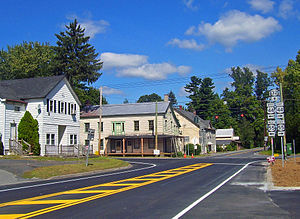
Center of Modena at junction of routes 44/55 and 32.

Modena is an unincorporated hamlet in Ulster County, New York, United States. It is located in the northwestern corner of the town of Plattekill, centered at the junction of the US 44/NY 55 concurrency and NY 32. It has the ZIP Code 12548.

It takes its name from Mary of Modena, newly wed to James II when it was first settled in the late 17th century. Today it in turn lends its name to a service area nearby on the southbound New York State Thruway.

It has long been a primarily rural community with minimal development, although that has been changing enough for Hannaford to build one of its supermarkets on Route 32 just south of the junction.

Coordinates: 41°40′05″N 74°06′22″W / 41.6680°N 74.1061°W / 41.6680; -74.1061


Wikimedia Foundation. 2010.

Игры ⚽ Нужна курсовая?

Look at other dictionaries:

  • New York Air Route Traffic Control Center — (ZNY) is one of 22 Air Route Traffic Control Centers (ARTCC) in the United States. Contents 1 Area of responsibility 2 The Basic Breakdown 3 Area Breakdown 4 …   Wikipedia

  • New York State Route 55 — This article is about the current alignment of NY 55. For the former alignment of NY 55 in Orange County, see New York State Route 55 (1920s–1930). NYS Route 55 Map of southeastern New York …   Wikipedia

  • New York State Route 32 — NY 32 redirects here. NY 32 may also refer to New York s 32nd congressional district. This article is about the current alignment of NY 32. For the former alignment of NY 32 in Erie and Niagara Counties, see New York State Route 32 (1920s–1930).… …   Wikipedia

  • New York State Route 55 — Karte …   Deutsch Wikipedia

  • New Paltz (village), New York — Coordinates: 41°45′N 74°5′W / 41.75°N 74.083°W / 41.75; 74.083 …   Wikipedia

  • New Paltz, New York — This article is about the town. For the village, see New Paltz (village), New York. Coordinates: 41°44′53″N 74°05′06″W / 41.74806°N 74.085°W …   Wikipedia

  • Napanoch, New York —   CDP   Downtown Napanoch, 2007, with Hoornbeek Store Complex on right …   Wikipedia

  • Olive, New York —   Town   …   Wikipedia

  • Cragsmoor, New York —   CDP   …   Wikipedia

  • Denning, New York — Coordinates: 41°57′08″N 74°29′20″W / 41.95222°N 74.48889°W / 41.95222; 74.48889 …   Wikipedia

Share the article and excerpts

Direct link
Do a right-click on the link above
and select “Copy Link”