- Rondout Creek
Geobox|River
name = Rondout Creek
native_name =
other_name =
category =
etymology =
nickname =

image_caption = Rondout Creek at the eastern edge of the Catskills,
between Napanoch andRondout Reservoir .
country =United States
state =New York
region = Catskills
district_type = Counties
district = Ulster, Sullivan
municipality = Towns of Olive, Denning, Neversink Wawarsing,
Marbletown, Rochester, Rosendale, Esopus,
Ulster
parent
tributary_left =Ver Nooy Kill ,Rochester Creek
tributary_right =Coxing Kill ,Wallkill River
city = Kingston
landmark =Rondout Reservoir
landmark1 = High Falls
source = Rocky Mountain
source_location = Olive | source_region = | source_country =
source_elevation_imperial = 2980
source_lat_d = 41| source_lat_m = 58 | source_lat_s = 17| source_lat_NS = N
source_long_d = 74| source_long_m = 21| source_long_s = 56| source_long_EW = W
mouth =Hudson River
mouth_location = Kingston | mouth_region = | mouth_country =
mouth_elevation_imperial = 0
mouth_lat_d = 41| mouth_lat_m = 55| mouth_lat_s = 12| mouth_lat_NS = N
mouth_long_d = 73| mouth_long_m = 57| mouth_long_s = 46| mouth_long_EW = W
length_imperial = | length_orientation =
width_imperial = | width_orientation =
depth_imperial =
volume_imperial =
watershed_imperial = 1100
watershed_note = PDFlink| [http://www.nyswaterfronts.com/downloads/pdfs/sig_hab/hudsonriver/Rondout_Creek.pdf COASTAL FISH & WILDLIFE HABITAT RATING FORM for Rondout Creek] |193 KiB ]
discharge_imperial = 1600
discharge_max_imperial = 35000
discharge_max_note = Cite web|url=http://nwis.waterdata.usgs.gov/ny/nwis/peak/?site_no=01367500&agency_cd=USGS|title=Peak Streamflow data for New York, Rondout Creek|accessdate=2007-12-28]
discharge_min_imperial =
free = | free_type =
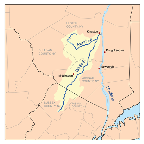
map_caption = Rondout/Wallkill watersheds
map_background =
map_locator =
map_locator_x =
map_locator_y =
website =
footnotes =Rondout Creek is a
tributary of theHudson River in Ulster and Sullivan counties,New York ,USA . It rises on Rocky Mountain in the eastern Catskills, flows south intoNew York City 'sRondout Reservoir , then into the valley between the Catskills and theShawangunk Ridge , where it goes over the spectacular High Falls and finally out to the Hudson at Kingston, receiving along the way theWallkill River .The name of the Rondout Creek comes from the fort, or redoubt, that was erected near its mouth The Dutch equivalent of the English word redoubt (meaning a fort or stronghold), is reduyt.In the Dutch records of Wildwyck, however, the spelling used to designate this same fort is invariably Ronduyt during the earliest period, with the present form rondout (often capitalized) appearing as early as November 22, 1666. Because the spelling of the word was unusual and implied a proper name, the translators, Oppenheim and Versteeg, preserved the original form in their translations instead of giving the English equivalent, as O´Callaghan and Fernow had done.The Dutch word ronduyt is an adjective meaning "frankly" or "positively." The word could also be broken down into its components and translated, literally, "round-out." However, it seems unlikely that the inhabitants of Esopus had any special meaning in mind when they corrupted the Dutch word reduyt into ronduyt and rondout. Most likely, this corrupting process merely represented the simplification of a word (reduyt). [http://www.hrmm.org/rondout/names.htm]
It became economically important in the 19th century when the
Delaware and Hudson Canal followed closely alongside it from Napanoch to the village of Rondout, now part of Kingston, which grew rapidly as the canal's northern port. Today it is important not only for the reservoir, but for the fishing and other recreational opportunities it provides.Due to the Wallkill, it drains a vast area stretching over 1,100 square miles (2,850 km²) all the way down to
Sussex County, New Jersey . The high mountains around its upper course and the reservoir, which collects water from three others, also add to it flow.Course
The Rondout goes through several different stages due to the changes in surrounding geography and past development, such as the canal and reservoir, that has drawn on its waters. Its
headwaters , above the reservoir, are a typical mountain stream. Below the reservoir it remains fairly rocky but widens into the floor of a narrow valley. At Napanoch, where it turns northeast and receives its first significant tributary, theVer Nooy Kill , it becomes wider, as does the valley it drains, and deeper.North of the Shawangunks, where the Wallkill trickles down from Sturgeon Pool, it is wide enough to be referred to as the Rondout River at some points. At Creeklocks, the former northern outlet of the canal, it becomes wide and deep enough to be navigable, and several
marina s line the banks of the stream, now more than a hundred feet (30 m) wide, at Kingston just above its mouth.Catskills and headwaters
Rising below the col between Rocky and Balsam Cap, The Rondout flows generally southerly down the slopes of Rocky into a narrow valley, receiving tributary
Picket Brook on the left and three unnamed streams from the slopes ofPeekamoose Mountain to the right. A mile or two from its source, it reaches some private lands and its first road, Peekamoose Road (Ulster County 42). It has dropped 1,440 feet (439 m) in its first two miles.cite map|publisher=United States Geological Survey (USGS)|title=Peekamoose Mountain quadrangle — Ulster County, New York|url=http://www.topoquest.com/map.asp?lat=41.92727&lon=-74.38045&size=l&u=6&datum=nad83&layer=DRG|accessdate=2008-07-20] It turns to the southwest to follow a wider valley, known informally as Peekamoose Gorge. Most of the land surrounding the creek is part of New York's Forest Preserve, "forever wild" and thus undeveloped. The rocky stream boasts several popularswimming hole s, one of which is known as Blue Hole for the greenish tone of the deep water within. South of the small outlet stream from Peekamoose Lake, it is crossed and then followed by Peekamoose Road, which at first runs high above the creek but then close by it.Along here it receives several tributaries from the right —
Buttermilk Falls Brook , with its eponymous waterfall near its mouth,High Falls Brook andBear Hole Brook ) — most of them rising, like the Rondout itself, in theSlide Mountain Wilderness Area to the west. To the east is another Forest Preserve management unit, theSundown Wild Forest . Some unnamed tributaries come from here. Because of theprotected area s on both sides of the creek and the ease of public access, this area has become one of the Catskills' populartrout streams, and fly-fishermen can be seen here during the season.It crosses under Peekamoose Road, here also carrying the
Long Path hiking trail, again just north of a popular camping area in the smallPeekamoose Wild Forest , and then passes the hamlet of the hamlet of Sundown and widens slightly as aflood plain develops alongside. The land aside the creek is now largely in private hands, and there is little public access to it as it crosses into Sullivan County.Reservoir to Napanoch
After crossing under NY 55A, it widens into the reservoir just below Grahamsville and begins flowing more to the east-southeast. Routes 55 and 55A bracket the reservoir to the south and north respectively. One-third of the way along the reservoir's nine-mile (14 km) length, it crosses back into Ulster County. Now at an elevation of 840 feet (256 m),cite map|publisher=USGS|title=Rondout Reservoir quadrangle — Ulster and Sullivan counties, New York|url=http://www.topoquest.com/map.asp?lat=41.79918&lon=-74.42945&size=l&u=6&datum=nad83&layer=DRG&scale=50|accessdate=2008-07-20] The creek resumes at the site of the former hamlet of Lackawack, leaving the
Catskill Park , now headed eastwards, in a rocky, wider streambed through some slightly more development.It follows closely alongside Route 55, deviating from it only when it turns north to
Honk Lake , another impoundment. Past here it crosses under 55 again and comes into Napanoch,. After crossing under US 209 and receiving theVer Nooy Kill it bends northeast, paralleling theShawangunk Ridge and the edge of the Catskill Plateau.Rondout Valley
The creek, now wider and deeper, forms the bed of a widening valley as it continues northeast past
Eastern Correctional Facility , where the first remnant of the canal, an empty ditch next to an old railroad station, can be found alongside. towards Kerhonkson, where Route 55 and US 44 cross over. 209 continues paralleling the Rondout towards High Falls, as it begins to curve to the east around the northern end of the ridge.Here, it goes over the spectacular
waterfall that gives the community its name, just below NY 213. These have been the subject of much controversy in recent years, since they are both a popular swimming hole and anattractive nuisance . The localfire department , which owned the land, had to sell it to keep itsliability insurance premium s affordable, and the new owner has posted the property for the same reason. However, swimmers routinely descend on the area on warm days.Lower Rondout and Kingston
Around the north end of the Shawangunks, it receives as tributaries many of the streams of the
Minnewaska State Preserve :Peters Kill ,Stony Kill andCoxing Kill . It begins to curve more to the east again. Route 213 replaces Route 209 as the Rondout's paralleling road, with the canal's empty ditch running next to both along the way to Rosendale, the next settlement, which grew up around the canal and, later, a local cement industry that used the creek to get its product to market.Here it crosses under Route 213 and NY 32 in a gravel-lined flood control channel, but returns to a more natural bed shortly afterwards to flow beneath the
New York State Thruway . In the wooded areas east of the Thruway, theWallkill River , its flow attenuated bySturgeon Pool just upriver, joins in from the south. The Rondout turns north, then east again, crossing Route 213 again. At Creeklocks the last lock and the end of the canal are still visible.
300px|thumb|left|Rondout just above mouth at KingstonIn Kingston itself it widens and flows under a pair of bridges, the historicKingston-Port Ewen Suspension Bridge , which carried US 9W until the construction of the neighboringJohn T. Loughran Bridge . The city's West Strand neighborhood along the waterfront has been rejuvenated in recent years and many boats can be seen moored at docks here on summer weekends. Old shipbuilders' factories line the northern bank, and one of them has been converted into theHudson River Maritime Museum . After a slight curve through swampier, less developed lowlands in the Kingston Point neighborhood, the Rondout empties into the Hudson atRondout Lighthouse , just opposite Rhinecliff.History
Colonial era
The early Dutch settlers realized the value of the creek for their colonial ambitions, and established a
trading post in the early 17th century, to deal with the local Native Americans, who likewise frequented the area. In 1652, an Englishman, Thomas Chambers, became the first permanent inhabitant at the site, the genesis of present-day Kingston. Unlike the Esopus, the Rondout played only a minimal role in the area's early settlement, since the northerly creek was navigable for a greater distance inland and had more farmland on its banks.cite web|title= A Tale of Two Ports: Newburgh and Kingston on the Hudson|url=http://www.ulster.net/~hrmm/museum/exhibit05.htm|accessdate=2007-12-28]Canal era
Settlement did slowly progress inland, but it was not until well after
American independence that the Rondout would become economically important. In the early 1820s two Philadelphia businessmen realized the immense profits that could be made if they could find a way to get the mostly unmined high-qualityanthracite coal from undevelopedNortheastern Pennsylvania to the lucrative markets ofNew York City . Railroads had not yet been perfected, so they saw the possibility of a canal running fromHonesdale, Pennsylvania to the Hudson at what was then the village of Rondout. In 1828 they obtained a charter for their company to do this, and theDelaware and Hudson Canal was opened a few years later. Coal was transferred from canalbarge s to river ships at Rondout, and it became a boomtown quickly. The canal remained a prosperous operation until late in the 19th century when rail transportation finally became more affordable, and ended its days in 1904 after a brief period carrying Rosendale cement. The former terminal port area for the canal is now Kingston'sRondout-West Strand Historic District , listed on theNational Register of Historic Places .Reservoir era
In the mid-20th century, the stream would find another important use. Naturalist
John Burroughs had anticipated it when he explored the upper headwaters with a friend early in the century, writing in his essay "A Bed of Boughs" of the purity of the stream's waters and its benefits for both man and fish:Starting in 1915 with
Ashokan Reservoir , New York City had been expanding its water supply system with reservoirs in the Catskills. In 1937 it began construction of Merriman Dam near Lackawack, which would soon be flooded forever to allow the growing city to tap the pure waters Burroughs had written about. Those waters began to reach city taps in 1951, and the reservoir itself was completed three years later. Today, via theDelaware Aqueduct , and the connections it has via theNeversink Aqueduct to the Neversink, Pepacton and Cannonsville reservoirs to the west supplementing the upper Rondout's drainage, it supplies half the city's daily water draw.ee also
*
List of New York rivers
*List of crossings of Rondout Creek References
External links
*YouTube|5-EqZ0__JMs|Peekamoose Blue Hole at Rondout Creek in the Catskills
Wikimedia Foundation. 2010.