- Dickinson, Broome County, New York
-
- There is another Dickinson in Franklin County, New York, U.S..
Dickinson, New York — Town — Cutler Botanic Gardens, Dickinson, NY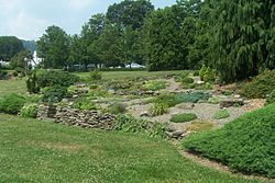 Location within the state of New York
 Dickinson, New York
Coordinates: 42°7′43″N 75°54′43″W / 42.12861°N 75.91194°WCoordinates: 42°7′43″N 75°54′43″W / 42.12861°N 75.91194°W Country United States State New York County Broome Government – Type Town Council – Town Supervisor Michael Marinaccio – Town Council Members' ListArea – Total 4.9 sq mi (12.6 km2) – Land 4.8 sq mi (12.4 km2) – Water 0.1 sq mi (0.2 km2) Elevation 843 ft (257 m) Population (2000) – Total 5,335 – Density 1,114.8/sq mi (430.4/km2) Time zone Eastern (EST) (UTC-5) – Summer (DST) EDT (UTC-4) ZIP code 13905 Area code(s) 607 FIPS code 36-20588 GNIS feature ID 0978903
Dickinson is a town in Broome County, New York, United States. The population was 5,335 at the 2000 census. The town was named after Daniel S. Dickinson.
The Town of Dickinson is adjacent to Binghamton and forms a suburban community to that city.
Contents
History
The Town of Dickinson was established in 1890 from the Town of Chenango.
The former Chenango Canal (1834–1876) passed through the town with a current village of Port Dickinson a port on the canal. The canal linked Binghamton to Troy, NY and the Erie Canal.
Geography
According to the United States Census Bureau, the town has a total area of 4.9 square miles (13 km2), of which, 4.8 square miles (12 km2) of it is land and 0.1 square miles (0.26 km2) of it (1.44%) is water.
The Town is divided by the Chenango River.
Interstate 81 joins Interstate 88 by the north town line. US Route 11 passes across the south part of the town, turning north on the west side of the Chenango River. New York State Route 7 a major north-south highway in the eastern part of Dickinson. New York State Route 17 is partly conjoined with I-81 in the town.
Adjacent towns and areas
To the North lie the towns of Union, Chenango, and Fenton. To the East is the Town of Kirkwood. To the South lies the City of Binghamton, and to the West, the town is bordered by the Town of Union and the Village of Johnson City.
Demographics
As of the census[1] of 2000, there were 5,335 people, 1,980 households, and 1,219 families residing in the town. The population density was 1,114.8 people per square mile (430.0/km²). There were 2,131 housing units at an average density of 445.3 per square mile (171.8/km²). The racial makeup of the town was 93.27% White, 4.20% African American, 0.09% Native American, 0.62% Asian, 0.82% from other races, and 0.99% from two or more races. Hispanic or Latino of any race were 1.78% of the population.
There were 1,980 households out of which 26.3% had children under the age of 18 living with them, 46.8% were married couples living together, 11.2% had a female householder with no husband present, and 38.4% were non-families. 33.5% of all households were made up of individuals and 15.3% had someone living alone who was 65 years of age or older. The average household size was 2.25 and the average family size was 2.87.
In the town the population was spread out with 19.0% under the age of 18, 8.6% from 18 to 24, 28.4% from 25 to 44, 23.5% from 45 to 64, and 20.4% who were 65 years of age or older. The median age was 41 years. For every 100 females there were 102.8 males. For every 100 females age 18 and over, there were 100.1 males.
The median income for a household in the town was $38,996, and the median income for a family was $49,583. Males had a median income of $33,654 versus $25,699 for females. The per capita income for the town was $19,246. About 4.6% of families and 7.2% of the population were below the poverty line, including 9.5% of those under age 18 and 5.0% of those age 65 or over.
Communities and locations in Dickinson
- Broome Community College – A public two year college west of the Chenango River.
- Cutler Botanic Gardens – A botanical garden in the town.
- Otsiningo Park – A park on the west bank of the Chenango River.
- Port Dickinson – The Village of Port Dickinson is on the east bank of the Chenango River.
References
- ^ "American FactFinder". United States Census Bureau. http://factfinder.census.gov. Retrieved 2008-01-31.
External links
Municipalities and communities of Broome County, New York City 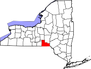
Towns Villages Deposit‡ | Endicott | Johnson City | Lisle | Port Dickinson | Whitney Point | Windsor
CDP Other
hamletsChenango Bridge | Chenango Forks | Hillcrest | Nineveh
Footnotes ‡This populated place also has portions in an adjacent county or counties
Categories:- Towns in New York
- Binghamton metropolitan area
- Populated places in Broome County, New York


Wikimedia Foundation. 2010.