- Maine, New York
-
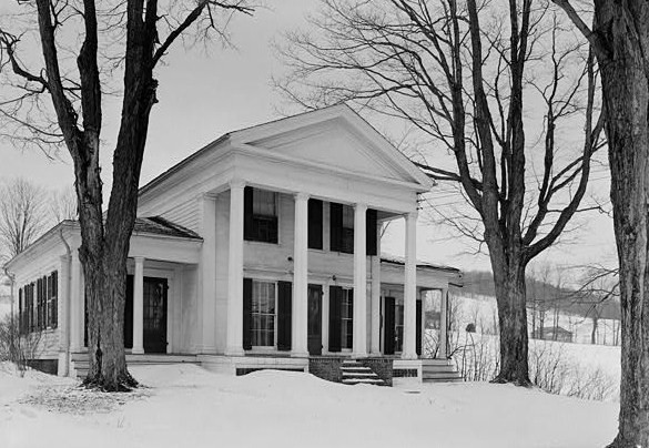
Maine, New York — Town — Cyrus Gates House, Maine, NY Location within the state of New York
 Maine, New York
Coordinates: 42°12′19″N 76°1′33″W / 42.20528°N 76.02583°W Country United States State New York County Broome Government - Type Town Council - Town Supervisor George Ludington - Town Council Members' ListArea - Total 45.8 sq mi (118.5 km2) - Land 45.7 sq mi (118.5 km2) - Water 0.0 sq mi (0.1 km2) Elevation 1,385 ft (422 m) Population (2000) - Total 5,459 - Density 119.4/sq mi (46.1/km2) Time zone Eastern (EST) (UTC-5) - Summer (DST) EDT (UTC-4) ZIP code 13802 Area code(s) 607 FIPS code 36-44611 GNIS feature ID 0979184 Maine is a town in Broome County, New York, United States. The population was 5,459 at the 2000 census.
The Town of Maine is on the western border of the county and is northwest of Binghamton.
Maine is home to the Greater Binghamton Airport. The airport services Binghamton and the surrounding area.
Contents
History
The town was first settled in 1794. The Town of Maine was formed from the northern part of the Town of Union in 1848.
The Maine Central School was listed on the National Register of Historic Places in 1998.[1] The Cyrus Gates Farmstead was listed in 1999.[1]
Geography
According to the United States Census Bureau, the town has a total area of 45.8 square miles (119 km2), of which, 45.7 square miles (118 km2) of it is land and 0.04 square miles (0.10 km2) of it (0.07%) is water.
The west town line is the border of Tioga County, New York.
New York State Route 26 is a north-south highway in the town. New York State Route 38B crosses the southwest corner Maine.
Demographics
As of the census[2] of 2000, there were 5,459 people, 2,036 households, and 1,531 families residing in the town. The population density was 119.4 people per square mile (46.1/km²). There were 2,181 housing units at an average density of 47.7 per square mile (18.4/km²). The racial makeup of the town was 97.89% White, 0.44% African American, 0.05% Native American, 0.53% Asian, 0.02% Pacific Islander, 0.07% from other races, and 0.99% from two or more races. Hispanic or Latino of any race were 0.55% of the population.
There were 2,036 households out of which 33.7% had children under the age of 18 living with them, 62.5% were married couples living together, 8.2% had a female householder with no husband present, and 24.8% were non-families. 19.9% of all households were made up of individuals and 8.3% had someone living alone who was 65 years of age or older. The average household size was 2.68 and the average family size was 3.08.
In the town the population was spread out with 26.3% under the age of 18, 6.7% from 18 to 24, 29.0% from 25 to 44, 24.9% from 45 to 64, and 13.1% who were 65 years of age or older. The median age was 39 years. For every 100 females there were 101.1 males. For every 100 females age 18 and over, there were 99.8 males.
The median income for a household in the town was $39,656, and the median income for a family was $42,514. Males had a median income of $33,363 versus $21,875 for females. The per capita income for the town was $17,773. About 4.5% of families and 5.9% of the population were below the poverty line, including 8.3% of those under age 18 and 5.6% of those age 65 or over.
Communities and locations in Maine
- Bowers Corners – A former location in the town.
- Greater Binghamton Airport/Edwin A Link Field (BGM) – The municipal airport of Binghamton.
- Maine – The hamlet of Maine is near the west town line on NY-26.
- East Maine – A hamlet southwest of the airport at the junction of County Roads 49 and 65.
- Nanticoke Creek – A stream flowing southward through the town.
- New Ireland – A hamlet by the east town line on County Road 89.
- North Maine – A former community in the town.
- Tiona – A location in the northwest part of the town.
References
- ^ a b "National Register Information System". National Register of Historic Places. National Park Service. 2009-03-13. http://nrhp.focus.nps.gov/natreg/docs/All_Data.html.
- ^ "American FactFinder". United States Census Bureau. http://factfinder.census.gov. Retrieved 2008-01-31.
External links
Coordinates: 42°11′33″N 76°03′40″W / 42.1925°N 76.06111°W
Municipalities and communities of Broome County, New York County seat: Binghamton City 
Towns Villages Deposit‡ | Endicott | Johnson City | Lisle | Port Dickinson | Whitney Point | Windsor
CDP Other
hamletsChenango Bridge | Chenango Forks | Hillcrest | Nineveh
Footnotes ‡This populated place also has portions in an adjacent county or counties
Categories:- Towns in New York
- Binghamton metropolitan area
- Populated places in Broome County, New York


Wikimedia Foundation. 2010.