- Sulphur Spring
-
Sulphur Spring 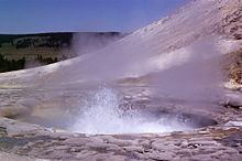
Sulphur Spring (Crater Hills Geyser)Location Hayden Valley, Yellowstone National Park, Park County, Wyoming Coordinates 44°39′17″N 110°28′54″W / 44.6546639°N 110.4817665°WCoordinates: 44°39′17″N 110°28′54″W / 44.6546639°N 110.4817665°W [1] Elevation 7,835 feet (2,388 m) Type Geyser Temperature 175 °F (79 °C) [1] Sulphur Spring (also known as Crater Hills Geyser), is a geyser in the Hayden Valley region of Yellowstone National Park in the United States.[2]
It is located in the Crater Hills area of Hayden Valley about 1 mile (1.6 km) west of the Grand Loop Road.
See also
References
- ^ a b "Sulphur Spring". Yellowstone Geothermal Features Database. Montana State University. http://www.rcn.montana.edu/resources/features/feature.aspx?nav=11&id=717.
- ^ Whittlesey, Lee (1999). Yellowstone Place Names. Wonderland Pub. Co.
Historic structures and other attractions in the Yellowstone Lake, West Thumb, South and East Entrance areasStructures and History 
West Thumb Geyser Basin Geography and Geology Barlow Peak • Buffalo Bill Cody Scenic Byway • Cody, Wyoming • Colter Peak • Eagle Peak (Wyoming) • Factory Hill • Hayden Valley • Heart Lake • Heart River (Wyoming) • Jackson, Wyoming • Lewis Falls • Lewis Lake • Lewis River • Mount Chittenden • Mount Doane • Mount Hancock • Mount Schurz • Mount Sheridan • Mount Stevenson • Shoshone Lake • Snake River • Sulphur Spring • Sylvan Pass • Yellowstone Lake • Yellowstone RiverList of Yellowstone National Park related articles
 Media related to West Thumb Geyser Basin at Wikimedia Commons
 State of Wyoming
Topics - Governors
- Delegations
- Geography
- Government
- History
- People
- Visitor Attractions
- State Symbols
- Radio Stations
Society - Crime
- Demographics
- Economy
- Education
- Politics
Regions Cities Counties Categories:- Geysers of Wyoming
- Geothermal features of Park County, Wyoming
- Yellowstone geothermal features
- Wyoming geography stubs

Wikimedia Foundation. 2010.