- New Zealand State Highway 3
-
State Highway 3

Route information Maintained by New Zealand Transport Agency Length: 500 km (300 mi) Major junctions North end:  SH 1 at Hamilton
South end:  SH 2 at Woodville
Location Primary
destinations:Te Awamutu, Otorohanga, Te Kuiti, New Plymouth, Hawera, Wanganui, Palmerston North Highway system New Zealand State Highways
Motorways and Expressways • List • Unused← SH 2SH 4  →
→State Highway 3 is one of New Zealand's eight national highways. It serves the west coast of the country's North Island and forms a link between State Highway 1 and State Highway 2. Distances are measured from north to south.
For most of its length SH3 is a two-lane single carriageway, with at-grade intersections and property accesses, both in rural and urban areas.
Contents
Route
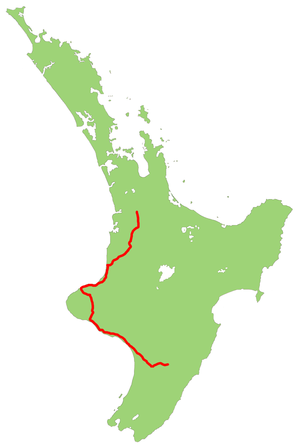
This is the route that SH3 takes in 2007.
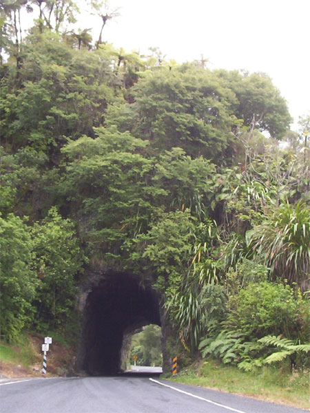
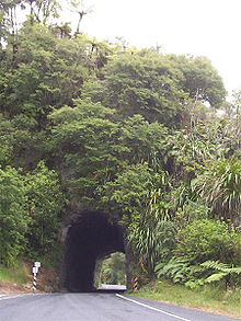 Tunnel at the north end of the Awakino Gorge. There is another short tunnel near the top of Mt Messenger
The highway leaves SH1 at Hamilton, and initially heads south through farmland, passing through Te Awamutu. Sections of this stretch of the road are four-laned, but not divided carriageway. From Otorohanga it follows the valley of the Waipa River to Te Kuiti. The road then turns southwest through sparsely settled farmland, crossing several ridges before following the Awakino gorge to reach the coast, which it follows around the North Taranaki Bight. At the Tongaporutu River the highway turns inland to avoid coastal cliffs and climbs over Mount Messenger before descending via the Mimi River valley to return to the coast near Urenui. Bypassing Waitara, it reaches New Plymouth then turns inland, passing to the east of Mount Taranaki via Inglewood, Stratford and Eltham to Hawera.
From Hawera the highway follows the coast of the South Taranaki Bight southeastwards to Patea and Wanganui before meeting State Highway 1 again at Bulls. Highways 1 and 3 share their route for 6 km as they cross the Rangitikei River to Sanson, where Highway 3 continues southeast towards Palmerston North. After crossing the Manawatu River, the route follows its south bank through the Manawatu Gorge to its terminus and junction with State Highway 2 at Woodville in the Wairarapa.
Both the Awakino and Manawatu gorges are prone to closure by slips and rockslides in heavy rain.
Route changes
Construction of a bypass of Bell Block, a satellite town of New Plymouth, was completed in 2010.
State Highway 3 spurs
SH3 has one spur, designated State Highway 3A. This 15.6 km stretch links State Highway 3 just west of Waitara to Inglewood, providing a shortcut and bypass of New Plymouth.
Major Junctions
Territorial authority Location km Destinations Notes Hamilton City Melville 0 SH 1/Thermal Explorer Highway north
(Kahikatea Drive)
AucklandSH 3 begins (Ohaupo Road)
Hospital1  SH 3
SH 3
(Normandy Ave)
City Centre, Rotoruato SH 1/Thermal Explorer Highway southWaipa District Hamilton Airport 10  SH 21
SH 21
(Airport Road)
Airport, Mystery CreekOtorohanga District Otorohanga 
 SH 31/SH 39
(Te Kanawa Street)
Kawhia, NgaruawahiaAlternative route to Auckland, bypassing Hamilton Waitomo District Hangatiki 65  SH 37
SH 37
(Waitomo Caves Road)
Waitomo CavesTe Kuiti 76  SH 30
SH 30
(Awakino Road)
Rotorua, TaupoEight Mile Junction 88 SH 4
Taumarunui, National ParkNew Plymouth District Brixton 229  SH 3A
SH 3A
(Mountain Road)
Inglewood, WanganuiAlternative route to Southern Taranaki, bypassing New Plymouth New Plymouth 240  SH 44
SH 44
(Eliot Street)
Port SH 45
SH 45
(Leach Street/Courtenay Street)
City Centre, OpunakeInglewood 258 SH 3A
(Rata Street)
HamiltonAlternative route to Hamilton, bypassing New Plymouth Stratford District Stratford 279  SH 43
SH 43
(Regan Street)
TaumarunuiSouth Taranaki District Hawera 310 SH 45
(Surf Highway)
OpunakeWanganui District Wanganui 402 Whanganui River Putiki SH 4
(Putiki Drive)
City Centre, National ParkRangitikei District Bulls 445 SH 1
(High Street)
TaupoSH 1/SH 3 concurrency begins 447 Rangitikei River Manawatu District Sanson 450 SH 1
(Wellington Road)
WellingtonSH 1/SH 3 concurrency ends Newbury 468  SH 54
SH 54
(Kairanga Bunnythorpe Road)
FeildingPalmerston North City Ashhurst 488 Manawatu River  SH 57
SH 57
(Fitzherbert East Road)
LevinTararua District 495 Manawatu River Woodville 500 SH 2/Classic NZ Wine Trail north
(Vogel Street)
NapierSH 3 ends SH 2/Classic NZ Wine Trail south
(McLean Street)
Masterton, WellingtonSee also
- List of New Zealand State Highways
- List of roads and highways, for notable or famous roads worldwide
New Zealand highways National SH 1 (incl. SH 1B) · SH 2 (incl. SH 2A, SH 2B) · SH 3 (incl. SH 3A) · SH 4 · SH 5 · SH 6 (incl. SH 6A) · SH 7 (incl. SH 7A) · SH 8 (incl. SH 8A, SH 8B)
North Island SH 10 · SH 11 · SH 12 · SH 14 · SH 15A · SH 16 · SH 17 · SH 18 · SH 20 · SH 21 · SH 22 · SH 23 · SH 24 · SH 25 (incl. SH 25A) · SH 26 · SH 27 · SH 28 · SH 29 · SH 30 (incl. SH 30A) · SH 31 · SH 32 · SH 33 · SH 34 · SH 35 · SH 36 · SH 37 · SH 38 · SH 39 · SH 41 · SH 43 · SH 44 · SH 45 · SH 46 · SH 47 · SH 48 · SH 49 · SH 50 (incl. SH 50A) · SH 53 · SH 54 · SH 56 · SH 57 · SH 58South Island Touring Routes Twin Coast Discovery Highway · Thermal Explorer Highway · Pacific Coast Highway · Classic New Zealand Wine Trail · Alpine Pacific Triangle · Great Alpine Highway · Foothills Scenic Route · Southern Scenic RouteCategories:- State highways in New Zealand

Wikimedia Foundation. 2010.