- New Zealand State Highway 6
-
State Highway 6

Route information Maintained by New Zealand Transport Agency Length: 1,162 km (722 mi) Tourist
routes:Southern Scenic Route between Invercargill and Lorneville Major junctions North end: Blenheim South end: Invercargill Location Primary
destinations:Nelson, Murchison, Inangahua Junction, Runanga, Greymouth, Hokitika, Haast, Wanaka, Cromwell, Queenstown, Lumsden, Winton Highway system New Zealand State Highways
Motorways and Expressways • List • Unused←  SH 5
SH 5SH 7  →
→ State Highway 6 near Kumara Junction.
State Highway 6 is a major New Zealand State Highway. It extends from the northeastern corner of the South Island across the top of the island, then down the length of the island, initially along the West Coast and then across the Southern Alps through inland Otago and finally across the Southland Plains to the island's south coast. Distances are measured from north to south.
The highway is the longest single highway in the country, though it is shorter than the combined totals of the two highways that comprise State Highway 1, SHs 1N and 1S.
For most of its length SH6 is a two-lane single carriageway, except for 5.4 km of dual carriageway in Invercargill, and passing lanes in Invercargill and Nelson, with at-grade intersections and property accesses, both in rural and urban areas. Roundabouts are common in major towns, with traffic signals only found in Invercargill, Richmond, and Nelson, with signals controlling the Kawarau Bridge in Queenstown and Hawks Crag near Westport.
Contents
Route
Nelson/Marlborough
The highway leaves SH1 at Blenheim, initially heading northeastward across the rugged hills at the base of the Marlborough Sounds. it reaches the sounds briefly at Havelock, then heads inland up the valley of the Pelorus River. At Pelorus Bridge the highway again turns north, then tends southwest as it approaches the coast of Tasman Bay. The highway travels through the city of Nelson and nearby town of Richmond, continuing southwest across the plains of the Wairoa and Motueka Rivers.
From these plains, the road ascends rapidly to the 613-metre Hope Saddle. From here, the highway heads generally westward, along the valley of the Buller River and its tributaries. Beyond Murchison, this valley narrows to become the scenic Buller Gorge, and the highway twists its way high above the waters of the river.
West Coast
The highway leaves the river as its valley broadens, turning south six kilometres from Westport, where the river reaches the sea. From here, the highway keeps close to the Tasman coast from Charleston for over 100 kilometres, turning inland only briefly near Runanga. This 100-kilometre stretch includes two of the coast's larger towns, Greymouth and Hokitika.
From Hokitika, the highway moves away from the coast, though still generally keeps within five kilometres of the sea. The highway continues south past Ross and Harihari, moving through state forests as it crosses several fast-moving rivers. Seventy kilometres south of Harihari, the highway skirts Lake Mapourika and reaches the tourist settlement of Franz Josef Glacier. The glacier itself, one of two within easy walking distance of the highway, lies nearby in the Southern Alps, which here come very close to the Tasman coast. The second glacier, Fox Glacier is located some 20 kilometres further south. The highway again briefly touches the coast at Bruce Bay before heading inland past Lake Paringa, before reemerging on the Tasman coast at Knights Point. The 30 km stretch of highway from here south to Haast is noted for its rugged scenery. After crossing the Haast River, the highway turns eastward and inland up the river's valley, climbing past the Gates of Haast and crossing the 563-metre Haast Pass, the southernmost of the three main road passes across the Southern Alps.
Otago
From here, the highway again turns south, following the Makarora River valley to the northern tip of Lake Wanaka. The highway skirts the eastern coast of the lake before crossing The Neck, a saddle in the mountains that lie between Lakes Wanaka and Hawea. The highway continues along the western shore of Hawea, then south along the Cardrona River to Albert Town, close to the tourist centre of Wanaka.
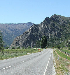 State Highway 6 at the Nevis Bluff.
 State Highway 6 skirts the slopes of The Remarkables and shore of Lake Wakatipu south of Queenstown.
Ten kilometres from Wanaka, the highway is met by SH 8A, a spur of SH 8 skirting the shore of Lake Dunstan. SH 6 continues south along the western shore of the Lake, paralleling SH 8 which lies on the eastern shore. Close to Cromwell, a second spur, SH 8B, connects the two highways. From here, SH6 turns west, following the narrow and twisting Kawarau Gorge, emerging close to the wine-producing area of Gibbston.
At the western end of the Kawarau Gorge, midway between Cromwell and Queenstown, the highway passes the Nevis Bluff, a steep schist rock outcrop rising 100 m above the Kawarau River. The highway has a history of being disrupted and closed at this point due to instability and rock falls from the bluff. The first road around the bluff was constructed in 1866, opening access to the Wakatipu goldfields.[1] Significant slips occurred at the bluff on 1940-02-20,[2] and blocking SH6 in June 1975.[3] On 17 September 2000, a large-scale rock fall buried the highway at the bluff, and several motorists narrowly avoided being killed. The fall was caught on video and showed a volume of 10,000 m³ for the main fall; the resulting dust cloud was seen 5 km away.[4][5] Transit New Zealand conducted stabilisation drilling and blasting at the bluff twice in 2006 and again in 2007.[6]
From the Nevis Bluff, the highway continues west, reaching Frankton, close to the shore of Lake Wakitipu. The highway turns south to follow the southeastern shore of the lake, skirting the foot of The Remarkables and the Hector Mountains. This stretch of the highway is in part tortuously winding, and rises and falls over a stretch known as "The Devil's Staircase".
Southland
The highway leaves the lake's shore at Kingston, continuing south to Garston, where, the highway briefly follows the course of the infant Mataura River before heading across rolling hill country to the upper reaches of the Oreti River near Lowther. The highway continues to follow the Oreti south across the Southland Plains, past the towns of Lumsden and Winton before reaching its terminus at a junction with SH 1 in central Invercargill.
State Highway 6 spurs
SH6 has one spur, designated
 State Highway 6A (also part of the
  Southern Scenic Route). This 6.9 km highway links Frankton with the tourist centre of Queenstown.
Engineering features
- Hawk's Crag is a single-lane half tunnel blasted out of a solid rock bluff in the Buller Gorge. It was constructed before 1900.[7]
- The highway featured a number of combined road-rail bridges, but several have now been replaced.
- The Haast River bridge (km 750.0) is now the longest single-lane bridge in the country, with two passing bays.[8]
Major junctions
Territorial authority Location km Destinations Notes Malborough District Blenheim 0 
 SH 1/Classic New Zealand Wine Trail north
(Grove Road)
Picton, Wellington FerrySH 6 begins SH 1/Classic New Zealand Wine Trail south
(Sinclair Street)
Kaikoura, ChristchurchRenwick 10  SH 63
SH 63
St Arnaud, WestportAlternative route to Westport, bypassing Nelson  SH 62
SH 62
(Rapaura Road)
PictonAlternative route to Picton, bypassing Blenheim Wairau River Nelson City District contains no major junctions Tasman District Richmond  SH 60
SH 60
(Appleby Highway)
Motueka, CollingwoodKawatiri 209 SH 63
St Arnaud, PictonAlternative route to Blenheim, bypassing Nelson Longford 238 Longford Bridge
Buller RiverAriki 255  SH 65
SH 65
Springs Junction, Christchurch (via Lewis Pass)O'Sullivan's Bridge
Buller RiverBuller District Lyell 282 Iron Bridge
Buller RiverInangahua Junction 297  SH 69
SH 69
Reefton, Greymouth, Christchurch (via Lewis Pass)Alternative route to Greymouth, bypassing Westport Westport  SH 67
SH 67
Westport, KarameaGrey District Greymouth 430 SH 7
(Omoto Road)
Reefton, Nelson, Christchurch (via Lewis Pass)Alternative route to Nelson, bypassing Westport Westland District Kumara Junction 448  SH 73
SH 73
(Otira Highway)
Arthur's Pass (mountain pass), ChristchurchNo major intersections for 367 km 815 Haast Pass
564 m (1,850 ft)Queenstown Lakes District Albert Town 891 Clutha River Mt Iron 893  SH 84
SH 84
(Wanaka Luggate Highway)
WanakaCentral Otago District Luggate 901  SH 8A
SH 8A
(Shortcut Road)
Aoraki/Mount Cook, Christchurchvia Lindis Pass Cromwell 942  SH 8B
SH 8B
Cromwell, Aoraki/Mount Cook, DunedinQueenstown Lakes District Frankton 996 SH 6A/ Southern Scenic Route
(Frankton Road)
QueenstownSH 6/Southern Scenic Route concurrency begins Southland District Athol 1061 Mataura River Five Rivers 1082  SH 97/ Southern Scenic Route
(Mossburn Five Rivers Road)
Te Anau, Milford Sound/PiopiotahiAlternative route to Te Anau, bypassing Lumsden
SH 6/Southern Scenic Route concurrency endsLumsden 1093  SH 94 west
(Mossburn Lumsden Highway)
Te Anau, Milford Sound/PiopiotahiSH 6/SH 94 concurrency begins 1095 SH 94 east
(Flora Road)
GoreSH 6/SH 94 concurrency ends Winton  SH 96 west
(Winton Wreys Bush Highway)
Nightcaps, OhaiSH 6/SH 96 concurrency begins SH 96 east
(Winton Hedgehope Highway)
MatauraSH 6/SH 96 concurrency ends Invercargill City Lorneville  SH 98
SH 98
(Lorne Dacre Road)
Dacre, GoreAlternative route to Gore, bypassing Invercargill  SH 99/ Southern Scenic Route
(Wallacetown Lorneville Highway)
Riverton/Aparima, TuatapereSH 6/Southern Scenic Route concurrency begins Invercargill SH 1 north/ Southern Scenic Route east
(Tay Street)
Gore, DunedinSH 6 ends SH 1 south
(Clyde Street)
BluffSee also
- List of New Zealand State Highways
- List of roads and highways, for notable or famous roads worldwide
References
- ^ "Otago Goldfields Heritage Trail - Queenstown". New Zealand South. http://www.nzsouth.co.nz/goldfields/queenstown.html. Retrieved 2008-05-08.
- ^ "Transactions and Proceedings of the Royal Society of New Zealand 1868-1961". http://rsnz.natlib.govt.nz/volume/rsnz_73/rsnz_73_01_000910.html. Retrieved 2008-05-08.
- ^ Brown, Ian; Hittinger, Marc; Goodman, Richard (March 1980). "Finite element study of the Nevis Bluff (New Zealand) rock slope failure". Rock Mechanics and Rock Engineering 12 (3–4): p.231. http://www.springerlink.com/content/3hm4043722ww1256/. Retrieved 2008-05-08.
- ^ "Motorists lucky to flee slip near Queenstown". New Zealand Herald. 18 September 2000. http://www.nzherald.co.nz/section/1/story.cfm?c_id=1&objectid=151746. Retrieved 2008-05-08.
- ^ Hailliday, G.S.; McKelvey, R.J. (2004). "Video-analysis of an extremely rapid rockslope failure". Landslides: Evaluation and Stabilization. Taylor & Francis. pp. 1355. ISBN 0415356652. http://books.google.com/?id=y1XiYxsny8wC&pg=RA1-PA1355&lpg=RA1-PA1355. Retrieved 2008-05-08.
- ^ "SH 6 Nevis Bluff ' Traffic Delays". Transit New Zealand. http://www.transit.govt.nz/news/MediaReleaseView.do?MediaReleaseId=nz.govt.transit.transweb.content.news.MediaRelease-10423. Retrieved 2008-05-08.
- ^ ca. 1900 photo of Hawk's Crag
- ^ What is the longest bridge in New Zealand?, Transit New Zealand FAQs. Accessed 2008-06-09.
New Zealand highways National SH 1 (incl. SH 1B) · SH 2 (incl. SH 2A, SH 2B) · SH 3 (incl. SH 3A) · SH 4 · SH 5 · SH 6 (incl. SH 6A) · SH 7 (incl. SH 7A) · SH 8 (incl. SH 8A, SH 8B)
North Island SH 10 · SH 11 · SH 12 · SH 14 · SH 15A · SH 16 · SH 17 · SH 18 · SH 20 · SH 21 · SH 22 · SH 23 · SH 24 · SH 25 (incl. SH 25A) · SH 26 · SH 27 · SH 28 · SH 29 · SH 30 (incl. SH 30A) · SH 31 · SH 32 · SH 33 · SH 34 · SH 35 · SH 36 · SH 37 · SH 38 · SH 39 · SH 41 · SH 43 · SH 44 · SH 45 · SH 46 · SH 47 · SH 48 · SH 49 · SH 50 (incl. SH 50A) · SH 53 · SH 54 · SH 56 · SH 57 · SH 58South Island Touring Routes Twin Coast Discovery Highway · Thermal Explorer Highway · Pacific Coast Highway · Classic New Zealand Wine Trail · Alpine Pacific Triangle · Great Alpine Highway · Foothills Scenic Route · Southern Scenic RouteCategories:- State highways in New Zealand


Wikimedia Foundation. 2010.