- New Zealand State Highway 94
-
State Highway 94
Route information Maintained by New Zealand Transport Agency Length: 254.4 km (158.1 mi) Major junctions Southeast end: Gore CBD
SH 1 Main Street/Hokonui Drive
Northwest end: Milford Sound Location Primary
destinations:Riversdale, Lumsden, Mossburn, Te Anau, Homer Tunnel Highway system New Zealand State Highways
Motorways and Expressways • List • Unused←  SH 93
SH 93SH 95  →
→State Highway 94 is a New Zealand State Highway connecting the large Southland town of Gore with one of New Zealand's most popular destinations Milford Sound. It also passes the significant townships of Lumsden and Te Anau as well going through the Homer Tunnel (in this area it is also called the 'Milford Road', with the section from Te Anau up to the Sound being 119 km).[1] The road also goes through Fiordland and crosses the Main Divide of the Southern Alps.
It is regarded as one of the most scenic roads in New Zealand, and with a peak elevation of 940m, also one of the country's highest.[1] However, the "Milford Road" part is also one of the more dangerous public roads in New Zealand, with injury crash rates around 65% higher than the rest of New Zealand's network, and a fatality crash rate of almost twice average (per vehicle kilometre travelled),[2] making it the third most dangerous section of New Zealand's State Highway network (as of 2008).[3]
Contents
History
The alignment road was first surveyed in 1890 by London-born engineer Robert Holmes, who later became the Engineer-in-Chief of the Public Works Department. Holmes initially preferred a route starting at Lake Wakatipu and running northwest, but the decision was instead made to start from Te Anau.[1]
However, the project then languished in planning for 40 years, possibly because in 1889 road building had been removed from the brief of the Public Works Department, and only reinstated with much more limited authority in 1909.[1]
It took until 1935, to construct a rough road to the entrance of what would become Homer Tunnel.[1]
Route
As of 2010, this is the route State Highway 94 takes.
Gore to Te Anau
In Gore, SH 94 begins as Hokonui Drive and passes through the northern parts of Gore. Outside of Gore, the highway changes name to Waimea Highway and passes to the north of the Hokonui Hills, a place historically known for illicit moonshine distilling. On the other side of the hills lies Mandeville. The road then veers right and bisects the Waimea Plains to pass through the settlements of Riversdale (where the road names changes to Newcastle Street and then Lumsden Riversdale Highway once leaving the town) and Balfour. The road proceeds in a northwesterly direction to arrive in Lumsden (where it changes name to Flora Road).
From Lumsden, as Flora Road and Five Rivers Lumsden Highway, SH 94 merges with SH 6 and runs concurrently with SH 6 towards Queenstown for 2.5 kilometres between the Oreti River and the hills to the east before turning left to cross the river and back onto the plains as Mossburn Lumsden Highway. The road runs for a further 20 km towards Mossburn, the self-proclaimed deer capital of New Zealand (name change to Devon Street). Tourist traffic from Queenstown turn onto SH 94 here from SH 97. Beyond Mossburn, the road changes name to Te Anau Mossburn Highway, and runs underneath a terrace carved by the Oreti River to the north before passing through more arable farmland and the turnoff to go to Mavora Lakes, one of the locations used in the Lord of the Rings film trilogy. After the turnoff, the road heads into the hills and passes through undulating tussocklands and valleys before emerging back onto the plains at The Key. From The Key, the road proceeds on a more-or-less north-westerly direction across the plains before arriving at the lakeside resort of Te Anau.
Te Anau to Milford Sound - The Milford Road
In Te Anau, the road changes name to Luxmore Drive as it proceeds towards the town centre. Once there, the road swings to the right and becomes Milford Road, once outside the town limits the road changes name to Te Anau Milford Highway. The road then hugs the shoreline of Lake Te Anau for about 29 km until it reaches Te Anau Downs. From Te Anau Downs, the road veers right and enters the Eglinton Valley. The road then runs parallel to the right side of the Eglinton River for 33 km while it passes through Knobs Flat. At Cascade Creek, the road emerges onto the shorelines of Lake Gunn and Lake Fergus. The road then passes through a saddle and emerges at the upper section of the Hollyford Valley.
After Hollyford, the road veers to the west and rises steadily along the valley to its highest point at the Homer Tunnel. At 1270 metres long it is the second-longest road tunnel in New Zealand (after the Lyttelton road tunnel). The road then emerges at the head of the Cleddau Valley and the road spends its last 16 kilometres descending along the valley to Milford Sound.
Tourist attractions
The Milford Road section began in 1926 when John Chartres, a local Station Owner, started making his own road from Te Anau Downs Harbour south to the Te Anau Hotel, starting a project which turned into the most scenic highway in New Zealand including iconic landmarks the Mirror Lakes, the Avenue of Disappearing Mountain, Lake Gunn, the Key Summit, Mount Christina, Mount Talbot, the Homer Tunnel, The Chasm, Mount Tutoko and Mitre Peak. Before the sealing of the road in the 1980s it was treated as a day's adventure from the township of Te Anau and Milford Sound the climax of the journey. Modern marketing and faster buses have made Milford Sound a destination from Queenstown involving 8 hours of bus transit, a round trip with few stops. This route is part of the Te Wai Pounamu Wilderness Area.
The Eglinton Mountains above Lake Gunn were used as a location in the Peter Jackson movie The Fellowship of the Ring where the actors walk along a mountain path with the Key Summit evident in the distance. The mountains here were also used in the Fellowship of the Ring introduction to represent the Misty Mountains. Emily Peak on the Routeburn Track can also be seen in this movie, as well as the Mavora Lakes near Mossburn. Ironically, Peter Jackson picked an area that once contained New Zealand's only place names from J. R. R. Tolkien that were removed from the official maps in the 1980s, as they were deemed inappropriate for this region.[4]
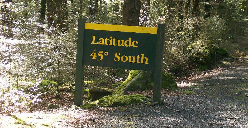
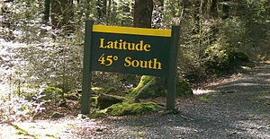 Crossing the Parallel
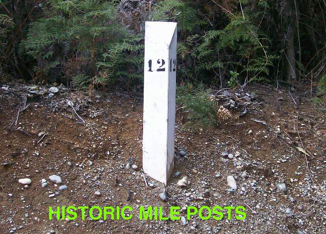
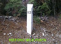 the 12 Mile Post
There are many places of Local History not signposted by Transit New Zealand, such as the Cleddau Horse Bridge, the Hollyford Hydro Powerstation remains, the Old Homer Tunnel construction village site, however Transit New Zealand has kept the historic White Mile Posts that are a feature of the early days of the Milford Road Construction. The Department of Conservation has kept up the Latitude 45 South Marker but has abandoned the Avenue of the Disappearing Mountain to history as the avenue of trees beside the Road has become over grown.
Outside of the Milford Road, Mandeville is the site of the Croydon Aircraft Company Link, and the local aerodrome is home to several rare vintage aircraft. Mossburn is the closest settlement to the Mount White Wind Farm which at full capacity can power almost all the entire Southland region. The Oreti, Mataura and Waiau Rivers that dominate the flatter regions of SH 94 between Gore and Te Anau are popular fishing spots for brown trout. Care should be taken while fishing to prevent the spread of Didymosphenia geminata.[5]
Driving State Highway 94
See also: Transport in Milford SoundTourists to Milford Sound arrive mainly via coach over the length of SH 94 from Mossburn, a predominantly high mountain road which is prone to avalanches in winter. The road was only opened in 1953, after the Homer Tunnel was finished, after almost 20 years of intermittent work. The road is one of the more dangerous public roads in New Zealand, with injury crash rates around 65% higher than the rest of New Zealand's network, and a fatality crash rate of almost twice average (per vehicle kilometre travelled),[2] making it the third most dangerous section of New Zealand's State Highway network (as of 2008).[3] Stopping is prohibited on long stretches due to rock or snow avalanche dangers, and the road is often closed in winter, with the carrying of snow chains mandatory during snow conditions. Helicopters are used during winter to drop explosives onto snow buildup zones above the road in order to cause controlled avalanches. However this does not eliminate the danger that road traffic may be hit by an uncontrolled event, especially in the area of the Homer Tunnel portals.[2]
There are no petrol stations on the length of the road from Te Anau to Milford Sound, meaning that vehicles need to take enough fuel for a return trip. All of this does not discourage up to 50 coaches and hundreds of private cars daily from making the 546 km trip from the nearest city Invercargill, and the 572 km trip from popular tourist destination Queenstown. Almost 60% of tourists travel via coach, which is regarded as being safer than attempting the road on your own.
Weather conditions
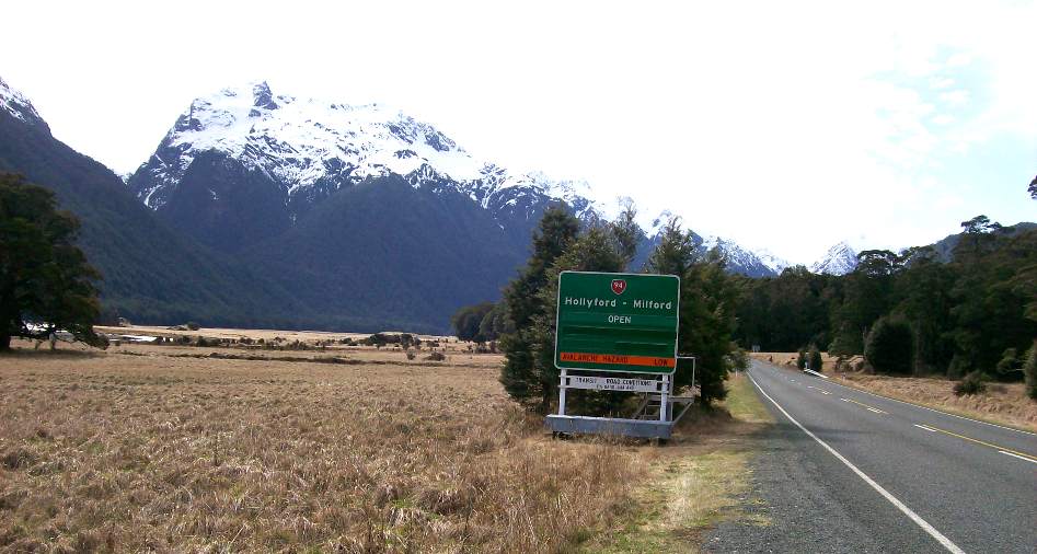
 Road Status Sign at Knobs Flat Rest Area
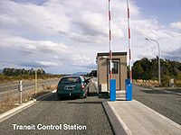
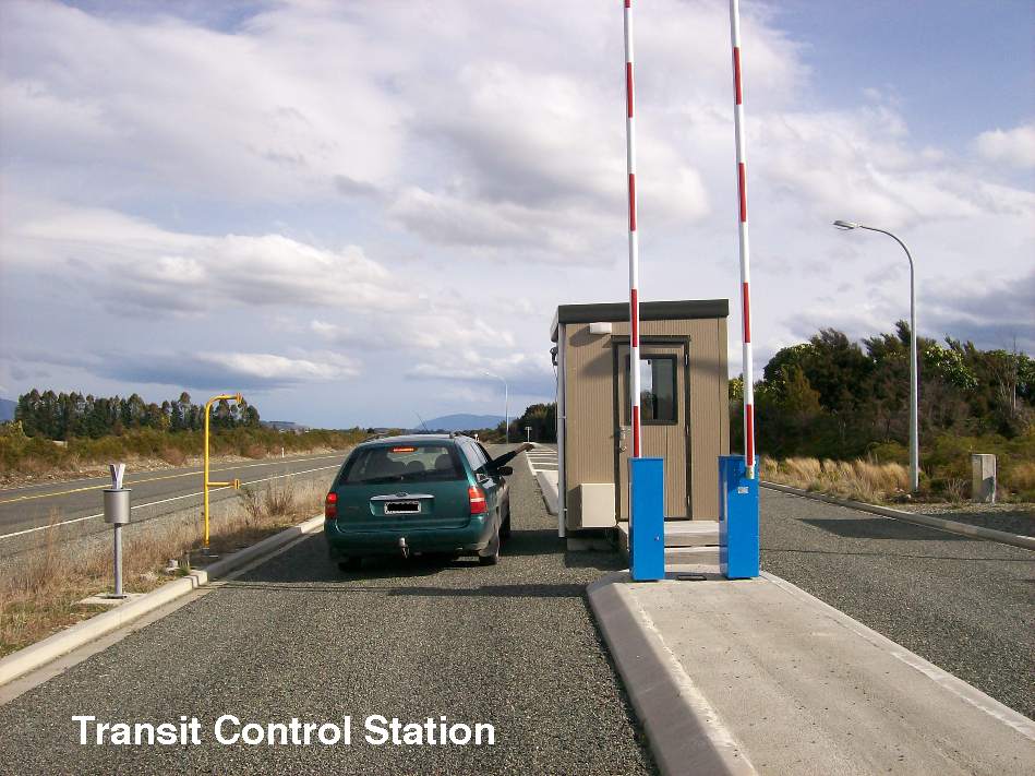
Avalanches are a winter hazard in the high mountains above the Milford Road and Snow and Ice effect the Road Surface in Winter Months, Transit Signs inform motorists of conditions and a Transit New Zealand check point has been built to make sure road users carry chains for safe passage to Milford Sound. Metal Gates are positioned across the Milford Road In the Hollyford and Cleddau Valleys when the road is closed at times of peak avalanche probability. Due to the nature of the Fiordland Environment, the road can be closed at any time of year from landslips treefalls and washouts. Snow can fall on higher parts of the road any time of the year.
However the entire length of SH 94 is susceptible to snowfall during the winter months and care should be taken at any time of the year, especially on the hillier regions between Mossburn and Milford Sound. Flooding can also occur at anytime along the road especially around rivers.
Literature on the Milford Road
Building the Milford Road section of SH 94 has been a classic story of danger, hardship and Kiwi ingenuity in the Depression Years and has been the subject of several books: Harold Anderson’s 1975 Men of the Milford Road, a detailed account of the project from his perspective as a Public Works Department Paymaster;[6] Wilson Campbell’s 2000 Novel When stars were brightly shining about a fictional murder in one of the works camps;[7] John Hall-Jones’s, Milford Sound An Illustrated History of the Sound, the Track and the Road, which covers in detail the history of the road with ample historic photographs;[8] and Amy McDonalds 2005 Below the Mountains, a young girl's diary of living on the Milford Road 1935 to 1936.[9] And there are mountain climbing books that cover this area in detail, such as Jack Ede’s 1988 “Mountain Men of Milford”[10] and Anita Crozier’s 1950 Beyond the Southern Lakes.[11]
Major junctions
Territorial authority Location km Destinations Notes Gore District Gore 0 SH 1 north
(Medway Street)
DunedinSH 94 begins SH 1 south
(Main Street)
InvercargillSouthland District Lumsden 61  SH 6 south
(Diana Street)
InvercargillSH 94/SH 6 concurrency begins 64 SH 6 north
(Five Rivers Lumsden Highway)
QueenstownSH 94/SH 6 concurrency ends Oreti River Mossburn 80  SH 97
SH 97
(Essex Street)
QueenstownThe Key 124 (Hillside Manapouri Road)
ManapouriTe Anau 138 SH 95/Southern Scenic Route
(Manapouri Te Anau Highway)
Lake Te Anau, Manapouri238 Homer Tunnel
1,270 m (4,170 ft) lengthMilford Sound 256 SH 94 ends See also
References
- ^ a b c d e "Making the Way to Milford". Engineering insight. IPENZ: pp. 37pp. January / February 2011.
- ^ a b c Strategy Study Summary Report - State Highway 94 Te Anau to Milford Sound (PDF) - Transit New Zealand, September 2001
- ^ a b Country's deadliest roads identified - NZPA via Newstalk ZB, Sunday 27 January 2008
- ^ Steve Rendle,The Dominion Post, November 22nd 2002 page A3
- ^ http://www.nzfishing.com/AboutFishingInNZ/FGRegionalPamphlets/STHpamphlets.htm Southland Fish & Game Access Pamphlets
- ^ ISBN 0 908629 27 3
- ^ ISBN 0 473 07036 7
- ^ Hall-Jones, John (2000). Milford Sound: an illustrated history of the sound, the track and the road. Invercargill, New Zealand: Craig. ISBN 0-908629-54-0.
- ^ ISBN 1 86943 663 6
- ^ 0 473 00682 0
- ^ ISBN 0 589 00893 5
Further reading
- Ian Brodie. (2003) The Lord of the Rings Location Guidebook, Harper Collins, ISBN 1-86950-491-7, 126 pages
- John Hall Jones. (2000) Milford Sound, Illustrated History, Harper Collins, ISBN 0-908629-54-0, 144 pages
External links
- Milford Road at the Department of Conservation
- State Highway 94 on GoogleMaps
- News
- "NEWS OF THE DAY - Motor Road to Milford". Evening Post. 4 June 1929. http://paperspast.natlib.govt.nz/cgi-bin/paperspast?a=d&d=EP19290604.2.34&. Retrieved 17 October 2010.
New Zealand highways New Zealand State Highway network · List of New Zealand State Highways National 
North Island SH 10 · SH 11 · SH 12 · SH 14 · SH 15A · SH 16 · SH 17 · SH 18 · SH 20 · SH 21 · SH 22 · SH 23 · SH 24 · SH 25 (incl. SH 25A) · SH 26 · SH 27 · SH 28 · SH 29 · SH 30 (incl. SH 30A) · SH 31 · SH 32 · SH 33 · SH 34 · SH 35 · SH 36 · SH 37 · SH 38 · SH 39 · SH 41 · SH 43 · SH 44 · SH 45 · SH 46 · SH 47 · SH 48 · SH 49 · SH 50 (incl. SH 50A) · SH 53 · SH 54 · SH 56 · SH 57 · SH 58South Island Touring Routes Twin Coast Discovery Highway · Thermal Explorer Highway · Pacific Coast Highway · Classic New Zealand Wine Trail · Alpine Pacific Triangle · Great Alpine Highway · Foothills Scenic Route · Southern Scenic RouteCategories:- Southland Region
- State highways in New Zealand
- Fiordland

Wikimedia Foundation. 2010.