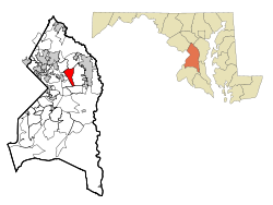
- Mitchellville, Maryland
-
Mitchellville, Maryland — CDP — Location of Mitchellville, Maryland Coordinates: 38°56′29″N 76°48′49″W / 38.94139°N 76.81361°WCoordinates: 38°56′29″N 76°48′49″W / 38.94139°N 76.81361°W Country United States State Maryland County Prince George's Area – Total 5.0 sq mi (12.9 km2) – Land 5.0 sq mi (12.9 km2) – Water 0.0 sq mi (0.0 km2) Elevation 105 ft (32 m) Population (2000) – Total 9,611 – Density 1,930.4/sq mi (745.3/km2) Time zone Eastern (EST) (UTC-5) – Summer (DST) EDT (UTC-4) ZIP codes 20716, 20717, 20721 Area code(s) 301 FIPS code 24-52975 GNIS feature ID 0597758 Mitchellville is an unincorporated area and census-designated place (CDP) in Prince George's County, Maryland, United States.[1] The population was 9,611 at the 2000 census. It is home to the Six Flags America theme park, Country Club at Woodmore, and Freeway Airport. The Capital Centre (later US Airways Arena) was located in Mitchellville.[2] Mitchellville, including its gated country-club community Woodmore,[citation needed] is one of the most affluent predominantly African American communities in the United States.[citation needed]
Contents
Geography
Mitchellville is located at 38°56′29″N 76°48′49″W / 38.941300°N 76.813616°W.[3]
According to the United States Census Bureau, the CDP has a total area of 5.0 square miles (13 km2), all of it land.
Demographics
Historical populations Census Pop. %± 1990 12,593 — 2000 9,611 −23.7% source:[4] As of the United States Census[5] of 2000, there were 9,611 people, 3,148 households, and 2,556 families residing in the CDP. The population density was 1,930.4 people per square mile (745.1/km²). There were 3,243 housing units at an average density of 651.4/sq mi (251.4/km²). The racial makeup of the CDP was 13.29% White, 78.50% African American, 0.26% Native American, 3.93% Asian, 0.06% Pacific Islander, 0.80% from other races, and 3.15% from two or more races. 2.09% of the population were Hispanic or Latino of any race.
There were 3,148 households out of which 41.1% had children under the age of 18 living with them, 61.8% were married couples living together, 15.3% had a female householder with no husband present, and 18.8% were non-families. 15.2% of all households were made up of individuals and 1.8% had someone living alone who was 65 years of age or older. The average household size was 3.02 and the average family size was 3.34.
In the CDP the population was spread out with 27.5% under the age of 18, 7.7% from 18 to 24, 28.5% from 25 to 44, 30.1% from 45 to 64, and 6.3% who were 65 years of age or older. The median age was 38 years. For every 100 females there were 86.9 males. For every 100 females age 18 and over, there were 82.8 males.
The median income for a household in the CDP was $84,687, and the median income for a family was $91,297. Males had a median income of $52,228 versus $46,648 for females. The per capita income for the CDP was $30,801. About 1.9% of families and 2.8% of the population were below the poverty line, including 3.7% of those under age 18 and 7.3% of those age 65 or over.
History
Mitchellville was named for John Mitchell (1788–1862), who owned Essington Hall, the plantation that encompassed much of the area. He and his wife Mary Lanham are buried in the Mitchell Family Cemetery on Mitchellville Road.[6]
References
- ^ U.S. Geological Survey Geographic Names Information System: Mitchellville, Maryland
- ^ "Mitchellville CDP, Maryland." U.S. Census Bureau. Retrieved on August 28, 2009.
- ^ "US Gazetteer files: 2010, 2000, and 1990". United States Census Bureau. 2011-02-12. http://www.census.gov/geo/www/gazetteer/gazette.html. Retrieved 2011-04-23.
- ^ "CENSUS OF POPULATION AND HOUSING (1790-2000)". U.S. Census Bureau. http://www.census.gov/prod/www/abs/decennial/index.html. Retrieved 2010-07-18.
- ^ "American FactFinder". United States Census Bureau. http://factfinder.census.gov. Retrieved 2008-01-31.
- ^ Michael F., Dwyer (1974) ([dead link]). Maryland Historic Trust Inventory Form For State Historic Sites Survey PG:71B-8. Silver Spring, Maryland: Maryland National Capital Park and Planning Commission. pp. 3. http://www.mdihp.net/cfm/dsp_unitlist.cfm?county=pg&letter=M
Categories:- Populated places in Prince George's County, Maryland
- Census-designated places in Maryland
- Unincorporated communities in Maryland
- Baltimore–Washington metropolitan area
- Populated places in Maryland with African American majority populations
Wikimedia Foundation. 2010.


