- Maryland Route 38
-
Maryland Route 38
Kitzmiller Road 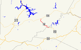
Maryland Route 38 highlighted in redRoute information Maintained by MDSHA Length: 5.67 mi[1] (9.12 km) Major junctions South end:  WV 42 in Kitzmiller
North end:  MD 135 near Kitzmiller
Location Counties: Garrett Highway system Maryland highway system
Interstate • US • State • Minor • Former • Turnpikes←  MD 37
MD 37MD 39  →
→Maryland Route 38 (MD 38) is a state highway in the U.S. state of Maryland. Known as Kitzmiller Road, the state highway runs 5.67 miles (9.12 km) from the West Virginia state line at the Potomac River in Kitzmiller, where the highway continues south as West Virginia Route 42 (WV 42), north to MD 135 on top of Backbone Mountain. MD 38 connects Kitzmiller with the rest of Garrett County and across the Potomac River to Blaine and Elk Garden in western Mineral County. The state highway was constructed in the late 1920s and early 1930s. MD 38 originally ran from U.S. Route 219 (US 219) near Thayerville through Deer Park and Altamont to Kitzmiller. The state highway was truncated at Backbone Mountain when MD 135 was extended west to Oakland in the mid 1950s.
Contents
Route description
MD 38 begins in the town of Kitzmiller at the Kitzmiller Bridge across the Potomac River. The highway continues on the other side of the river as WV 42 in Blaine. After passing Main Street, MD 38 begins its steep, curvy ascent of Backbone Mountain. The southbound direction of the state highway features a mandatory truck stop to check brakes at the top of the 2-mile (3.2 km) hill. Beyond the truck pull-off, MD 38 continues uphill at a more gentle gradient all the way to its northern terminus at MD 135 (Maryland Highway) on the ridgeline of Backbone Mountain.[1][2]
History
MD 38 originally extended north toward Deep Creek Lake. The state highway descended Backbone Mountain toward Altamont and continued west to Deer Park following what is now MD 135 and Edgewood Drive into the center of the town. In Deer Park, MD 38 turned north along Main Street and followed Sand Flat Road to US 219 near Thayerville.[3] MD 38 was paved from its original northern terminus through Deer Park to Altamont between 1924 and 1926.[4][5] The highway was extended east to the top of Backbone Mountain by 1930; this construction included the bridge over the Baltimore and Ohio Railroad at Altamont.[6][7] The present segment of MD 38 south to Kitzmiller was under construction by 1930 and completed in 1933.[7][8][9] The present bridge across the Potomac River and an approach road beginning at State Street on the north were completed in 1955.[10][11] This bridge replaced the original 1892 bridge that crossed the river just to the east of the present crossing.[10][12] MD 38 was rolled back to its current northern terminus on top of Backbone Mountain in 1956. MD 135 was relocated onto the portion of MD 38 between MD 38's present terminus and Deer Park and extended west toward Oakland. Sand Flat Road was transferred to county maintenance.[13]
Junction list
The entire route is in Garrett County.
Location Mile
[1]Destinations Notes Kitzmiller 0.00 WV 42 south – Blaine, WV, Elk Garden, WVSouthern terminus; West Virginia state line at Potomac River 5.67 MD 135 (Maryland Highway) – Oakland, WesternportNorthern terminus 1.000 mi = 1.609 km; 1.000 km = 0.621 mi Auxiliary routes
MD 38 has two auxiliary routes, both located at the highway's intersection with MD 135 on top of Backbone Mountain
- MD 38A is the designation for the tight 0.01-mile (0.016 km) ramp from northbound MD 38 to eastbound MD 135.[1]
- MD 38B is the designation for the sweeping 0.19-mile (0.31 km) ramp from eastbound MD 135 to southbound MD 38.[1][14]
References
- ^ a b c d e "Highway Location Reference: Garrett County" (PDF). Maryland State Highway Administration. 2009. http://www.marylandroads.com/Location/2009_GARRETT.pdf. Retrieved 2010-10-31.
- ^ Google, Inc. Google Maps – Maryland Route 38 (Map). Cartography by Google, Inc. http://maps.google.com/maps?f=d&source=s_d&saddr=W+Virginia+42+N&daddr=md-38+and+md-135+kitzmiller,+md&hl=en&geocode=FYT-WAIdMM1H-w%3BFX7UWQIdGwtH-ykZqbIRp1e1iTHmyheOjFa4SA&mra=ls&sll=39.392627,-79.189539&sspn=0.030446,0.077162&ie=UTF8&t=h&z=13. Retrieved 2010-02-27.
- ^ Maryland State Roads Commission. General Highway Map: State of Maryland (Map) (1939 ed.).
- ^ Report of the State Roads Commission of Maryland. 1924-1926. Baltimore: Maryland State Roads Commission. January 1927. pp. 54, 83. http://www.archive.org/details/annualreportsofs1924mary. Retrieved 2010-02-27.
- ^ Maryland Geological Survey. Map of Maryland: Showing State Road System and State Aid Roads (Map) (1927 ed.).
- ^ Report of the State Roads Commission of Maryland. 1927-1930. Baltimore: Maryland State Roads Commission. 1930-10-01. p. 68. http://www.archive.org/details/reportofstateroa1927mary. Retrieved 2010-10-31.
- ^ a b Maryland Geological Survey. Map of Maryland Showing State Road System: State Aid Roads and Improved County Road Connections (Map) (1930 ed.).
- ^ Maryland Geological Survey. Map of Maryland Showing State Road System: State Aid Roads and Improved County Road Connections (Map) (1933 ed.).
- ^ Report of the State Roads Commission of Maryland. 1931-1934. Baltimore: Maryland State Roads Commission. 1934-12-28. p. 336. http://www.archive.org/details/reportofstateroa1931mary. Retrieved 2010-10-31.
- ^ a b "Glimpse of the Past: The Old Kitzmiller Bridge" (JPG). The Republican (Oakland, MD). http://myweb.cebridge.net/townofkitzmiller/GOP_Old_Post_Office.jpg. Retrieved 2010-02-27.
- ^ Report of the State Roads Commission of Maryland. 1955-1956. Baltimore: Maryland State Roads Commission. 1956-11-02. p. 189. http://www.archive.org/details/annualreportsofs1955mary. Retrieved 2010-02-27.
- ^ U.S. Geological Survey. Elk Garden, WV quadrangle (Map). 1:48,000. 15 Minute Series (Topographic) (1922 ed.). http://historical.mytopo.com/quad.cfm?quadname=Elk%20Garden&state=WV&series=15. Retrieved 2010-02-27.
- ^ Maryland State Roads Commission. Maryland: Official Highway Map (Map) (1956 ed.).
- ^ Google, Inc. Google Maps – Maryland Route 38B (Map). Cartography by Google, Inc. http://maps.google.com/maps?f=d&source=s_d&saddr=Unknown+road&daddr=Unknown+road&hl=en&geocode=FbPSWQIdsQFH-w%3BFXPOWQIdaAxH-w&mra=ls&sll=39.441314,-79.231381&sspn=0.001902,0.004823&ie=UTF8&ll=39.440531,-79.23122&spn=0.001902,0.004823&t=h&z=18. Retrieved 2010-11-02.
External links
Roads in Garrett County, Maryland State highways 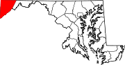
U.S. Highways Interstate Highways Categories:- State highways in Maryland
- Roads in Garrett County, Maryland


Wikimedia Foundation. 2010.