- North Cowichan, British Columbia
-
Municipality of North Cowichan — District Municipality — 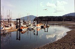
Flag
Coat of armsMotto: No Steps Backwards Location of North Cowichan in British Columbia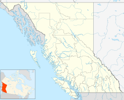
 Municipality of North Cowichan
Coordinates: 48°49′25″N 123°43′9″W / 48.82361°N 123.71917°WCoordinates: 48°49′25″N 123°43′9″W / 48.82361°N 123.71917°W Country Canada Province British Columbia Regional District CVRD Incorporated 1873 Government – Mayor Tom Walker – Governing body North Cowichan Council – MPs Jean Crowder – MLAs Bill Routley Area – Total 193.98 km2 (74.9 sq mi) Population (2006) – Total 27,557 – Density 142/km2 (367.8/sq mi) Time zone PST (UTC−8) – Summer (DST) PDT (UTC−7) Area code(s) +1-250 Website Municipality of North Cowichan 
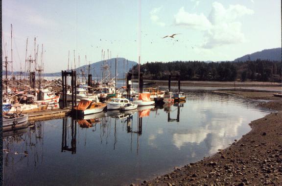
North Cowichan (Canada 2006 Census population 27,557) is a District municipality on Vancouver Island in British Columbia, Canada and is in the Cowichan Valley Regional District. North Cowichan is marked by a beautiful landscape including gorgeous forests, beaches, rivers and lakes.
Contents
Geography
Located on the east coast of Vancouver Island, North Cowichan is centrally located between the cities of Victoria to the south, and Nanaimo to the north. Vancouver is located to the east, separated by the Strait of Georgia. Spanning 193.98 square kilometers North Cowichan includes the communities of Chemainus, Crofton, Maple Bay and South End.
Geology
The last glacial period, the Fraser Glaciation occurred between 29,000 and 15,000 years ago. The glaciers that formed carved out the Cowichan Valley and left behind glacier till up to 30 metres thick. These fertile lands and mild climate have led to a history rich in agriculture.[1]
Climate
Sheltered by the mountains of the central Island and the Olympic Peninsula, North Cowichan has a temperate, Mediterranean-like climate, with mild, damp winters with little snowfall and warm, dry summers. North Cowichan enjoys Canada’s warmest mean temperature.
Demographics
North Cowichan has a population of 27,557 people in 2006, which was an increase of 5.4% from the 2001 census count. The median family income in 2006 for North Cowichan was $62,125, which is below the British Columbia provincial average of $65,787.[2]
Communities
- Chemainus
- Crofton
- Maple Bay
- South End
Transportation
North Cowichan is serviced by the Maple Bay Airport (YAQ), which offers services to Vancouver Downtown, Vancouver Airport, Ganges on Salt Spring Island and Bedwell Harbour on Pender Island. Service is provided by Saltspring Air and Harbour Air.
The British Columbia Highway 1 traverses the municipality. Bus service in the municipality is provided by the Cowichan Valley Regional District.
Economy
The original economic drivers steamed from the abundance of natural resources, including the fur trade, fishing, mining, and the forest industry. Today, the forest industry, retail, construction, manufacturing, and health care are large contributors to the local economy.
Education
North Cowichan lies within the School District 79 Cowichan Valley. There are many elementary schools, two middle schools, and two secondary schools.
North Cowichan is served by one public post secondary educational institution, Vancouver Island University.
Media Outlets
North Cowichan is served by three newspapers – the Cowichan News Leader Pictorial, the Cowichan Valley Citizen, and the Chemainus Courier. North Cowichan is also serviced by CJSU-FM (SunFM), a member of Vista Radio.
Attractions
North Cowichan is home to the BC Forest Discovery Centre, the Pacific Northwest Raptors Bird of Prey and Raptor Visitor Center, and the world famous Chemainus Murals.
Arts
The Cowichan Theatre hosts many performers and shows during the year. The Chemainus Theatre features classic and award winning comedies, musicals and dramas.
Recreation
North Cowichan is home to many recreation centres, including the Cowichan Aquatic Centre, Island Savings Centre, Fuller Lake Arena and the Cowichan Sportsplex. North Cowichan offers numerous parks and hiking trails.
Power Supply
The Vancouver Island terminal of the HVDC Vancouver-Island is found here.
North: Cowichan Valley G, Kuper Island West: Cowichan Valley E North Cowichan
North Cowichan completely surrounds HalaltEast: Squaw-hay-one, Tsussie 6, Capital F South: Duncan, Cowichan IR No. 1 Climate
Climate data for North Cowichan Month Jan Feb Mar Apr May Jun Jul Aug Sep Oct Nov Dec Year Record high °C (°F) 13.5
(56.3)18.5
(65.3)23.5
(74.3)28.5
(83.3)32.0
(89.6)34.0
(93.2)36.0
(96.8)34.5
(94.1)35
(95)27
(81)18
(64)15
(59)36
(96.8)Average high °C (°F) 6.6
(43.9)8.6
(47.5)11.3
(52.3)14.9
(58.8)18.5
(65.3)21
(70)24.5
(76.1)24.3
(75.7)22.5
(72.5)15.1
(59.2)9.6
(49.3)6.1
(43.0)15.25
(59.45)Daily mean °C (°F) 3.2
(37.8)4.3
(39.7)6.3
(43.3)9.2
(48.6)12.4
(54.3)15.0
(59.0)17.8
(64.0)17.5
(63.5)15.2
(59.4)10.0
(50.0)5.9
(42.6)3.1
(37.6)9.99
(49.99)Average low °C (°F) −0.2
(31.6)−0.1
(31.8)1.3
(34.3)3.5
(38.3)6.3
(43.3)9.0
(48.2)11.0
(51.8)10.7
(51.3)7.9
(46.2)4.9
(40.8)2.2
(36.0)0.2
(32.4)4.73
(40.51)Record low °C (°F) −14
(6.8)−15
(5.0)−10
(14.0)−3
(26.6)−1.5
(29.3)2.5
(36.5)5.0
(41.0)5.0
(41.0)0.0
(32.0)−4.5
(23.9)−10.5
(13.1)−15.5
(4.1)−15.5
(4.1)Precipitation mm (inches) 238.0
(9.37)164.0
(6.457)133.0
(5.236)85.0
(3.346)51.0
(2.008)40.0
(1.575)25.0
(0.984)33.0
(1.299)28.0
(1.102)117.0
(4.606)222.0
(8.74)229.0
(9.016)1,365
(53.74)Source: The Weather Network[3] References
- ^ "Geological History of Vancouver Island". CVRD. CVRD. http://www.crd.bc.ca/watersheds/protection/geology-processes/geologicalhistoryVI.htm.
- ^ "British Columbia — Community Fact". http://www.bcstats.gov.bc.ca/DATA/DD/facsheet/cf124.pdf. Retrieved 2010-11-29.
- ^ The Weather Network—Statistics: Duncan, BC. Retrieved 29 September 2011.
External links
 Subdivisions of British Columbia
Subdivisions Regions · Regional districts · Forest Regions and Forest Districts · School districts · Land DistrictsSettlements Urban centres District municipalities Barriere · Central Saanich · Chetwynd · Clearwater · Coldstream · Delta · Elkford · Esquimalt · Fort St. James · Highlands · Hope · Houston · Hudson's Hope · Invermere · Kent · Lake Country · Langley · Lantzville · Lillooet · Logan Lake · Mackenzie · Maple Ridge · Metchosin · Mission · New Hazelton · North Cowichan · North Saanich · North Vancouver · Oak Bay · 100 Mile House · Peachland · Port Edward · Port Hardy · Saanich · Sechelt · Sicamous · Sooke · Spallumcheen · Sparwood · Squamish · Stewart · Summerland · Taylor · Tofino · Tumbler Ridge · Ucluelet · Vanderhoof · Wells · West Kelowna · West VancouverCategories:- District municipalities in British Columbia
- Populated places in the Cowichan Valley Regional District
- Cowichan Valley
- Populated places on the British Columbia Coast
- British Columbia Coast geography stubs


Wikimedia Foundation. 2010.